St. Marys, Pennsylvania

Last updated

Saint Marys, Pennsylvania
City
St Marys City Hall Apr 10.JPG
Saint Marys City Hall
Flag of St. Marys, Pennsylvania.png
Seal of St. Marys, Pennsylvania.png
Elk County Pennsylvania incorporated and unincorporated areas St. Marys highlighted.svg
Location in Elk County and the U.S. state of Pennsylvania.
Coordinates: 41°25′40″N78°33′40″W / 41.42778°N 78.56111°W / 41.42778; -78.56111
Country United States
State Pennsylvania
County Elk
Settled1804
Incorporated (borough)1848
Incorporated (city)1992
Government
  MayorLyle Garner
Area
[1]
  Total99.51 sq mi (257.72 km2)
  Land99.32 sq mi (257.23 km2)
  Water0.19 sq mi (0.49 km2)
Elevation
1,666 ft (508 m)
Population
 (2020)
  Total12,738
  Density128.01/sq mi (49.43/km2)
Time zone Eastern (EST)
  Summer (DST)EDT
Zip code
15857
Area code 814
FIPS code 42-67344
Website City of Saint Marys

St. Marys is a city in Elk County, Pennsylvania, United States. The population is 12,738 as of the 2020 census. [2] Originally a small town inhabited by mostly Bavarian Roman Catholics, it was founded December 8, 1842. It is home to Straub Brewery and the first Benedictine convent in the United States. In 1992, the borough of St. Marys absorbed the surrounding township of Benzinger and incorporated as a city. [3] Despite its place as the second-largest city by area in Pennsylvania behind Philadelphia, it is one of the state's least densely populated cities.

Contents

St. Marys lies in the center of Pennsylvania's elk country. It is one of the few places east of the Mississippi River that allows hunting of wild elk. The area is known for its access to outdoor activities, including trout streams and state hunting lands inside the city limits. [ citation needed ]

Geography

St. Marys is located at 41°26′15″N78°32′34″W / 41.437600°N 78.542724°W / 41.437600; -78.542724 (41.437600, -78.542724). [4]

According to the United States Census Bureau, the city has a total area of 99.5 square miles (258 km2), of which 99.3 sq mi (257 km2) is land and 0.2 sq mi (0.52 km2) (0.16%) is water. Most of that area is unurbanized, and the large size is due to the city's 1992 merger with surrounding Benzinger Township. [3] The city is at a relatively high elevation of 1,666 ft (508 m) above sea level. The city's territory is bordered by Jones Township to the north, Cameron County to the east, Fox and Jay Townships to the south, and Ridgway Township to the west.

The downtown area lies directly on the Eastern Continental Divide, such that water on the eastern side of the city drains into the Atlantic Ocean, while the western side drains to the Gulf of Mexico. [5]

Demographics

Historical population
CensusPop.Note
1860 692
1870 1,08456.6%
1880 1,50138.5%
1890 1,74516.3%
1900 4,295146.1%
1910 6,34647.8%
1920 6,9679.8%
1930 7,4236.5%
1940 7,6533.1%
1950 7,8462.5%
1960 8,0652.8%
1970 7,470−7.4%
1980 6,417−14.1%
1990 5,511−14.1%
2000 14,502163.1%
2010 13,070−9.9%
2020 12,738−2.5%
Sources: [6] [7] [8]

As of the census [9] of 2010, there were 13,070 people, 5,579 households, and 3,695 families residing in the city. The population density was 131.6 inhabitants per square mile (50.8/km2). There were 6,124 housing units at an average density of 61.7 per square mile (23.8/km2). The racial makeup of the city was 98.5% White, 0.3% African American, 0.05% Native American, 0.4% Asian, 0.05% Pacific Islander, 0.1% from other races, and 0.6% from two or more races. Hispanic or Latino of any race were 0.4% of the population.

There were 5,579 households, out of which 26% had children under the age of 18 living with them, 52.8% were married couples living together, 9.1% had a female householder with no husband present, and 33.8% were non-families. 29.8% of all households were made up of individuals, and 14.2% had someone living alone who was 65 years of age or older. The average household size was 2.29 and the average family size was 2.82.

In the city, the population was spread out, with 20.1% under the age of 18, 59.5% from 18 to 64, and 20.4% who were 65 years of age or older. The median age was 45.6 years.

The median income for a household in the city was $45,802, and the median income for a family was $55,045. Males had a median income of $41,968 versus $29,489 for females. The per capita income for the city was $24,208. About 7% of families and 11.4% of the population were below the poverty line, including 20.3% of those under age 18 and 10.9% of those age 65 or over.

Transportation

St. Marys Municipal Airport lies in the city's southeastern quadrant and serves general aviation.

The city's main highways are PA 255 and PA 120. Bus service is provided by ATA; a daily Fullington Trailways bus line runs through St. Marys as well.

Education

Public school district

Saint Marys Area School District has two elementary schools, one of which, the South St. Marys Street Elementary School, is located within the city. It houses preschool through fifth-grade classes for public school students within the city limits; similar services are provided to residents of Fox Township, the Fox Township Elementary School in Kersey. The Bennett's Valley Elementary, for residents of Jay Township, was previously part of the Saint Marys Area School District but merged with Fox Township Elementary in 2023.

The St. Marys Area Middle School and the St. Marys Area High School are located next to each other on a large complex near the edge of the city. Grades 6-8 are taught at the middle school, and grades 9-12 are taught at the high school. Saint Marys Area School District was ranked 165th out of 498 Pennsylvania school districts by the Pittsburgh Business Times in 2012.

Catholic school system

St. Marys Catholic Elementary School has one building, which is connected to Queen of the World Church. In 2002, an addition was built, adding four classrooms and a gymnasium. It also recently had a playground added. It houses grades pre-K through 5.

St. Marys Catholic Middle School, is located in the same building as the Elk County Catholic High School. The middle school formerly occupied the old Saint Mary's Parochial school building that was built in the early 1950s. Elk County Catholic High School, formally Elk County Christian High School, houses grades 6-12. It was built in 1961. [10]

Until the early 2000s, the Catholic school system's elementary and middle schools, then known respectively as the Queen of the World School and the St. Marys Parochial School, each served all students up through eighth grade who attended their respective Catholic churches, as did the Sacred Heart School. When the school system was reworked into its current format due to declining attendance, the Sacred Heart School was closed.

Landmarks

Decker's Chapel has been called the smallest chapel in America. [11] It is located on South St. Marys Road.

St. Joseph Monastery, home of the Benedictine Sisters of Elk County, was the oldest Benedictine women's religious order in the United States, founded in 1852. In 2013, the sisters voted unanimously to dissolve the community. [12]

Straub Brewery, was founded in St. Marys in 1872 by Peter Straub (1850-1913) of Felldorf, Württemberg, Germany, who purchased the Benzinger Spring Brewery from his father-in-law, Francis Xavier Sorg. Brewing continuously since that time, Straub is the third oldest brewery in the United States and considered an American Legacy Brewery™.[ citation needed ] It is still owned and operated by the founding family, now in its seventh generation. Straub is also the smallest pre-Prohibition brewery still in business in the United States.

The Bucksgahuda and Western Railroad is a 2 ft (610 mm) narrow gauge [13] railroad run by enthusiasts.

Media

Notable people

Related Research Articles

<span class="mw-page-title-main">Elk County, Pennsylvania</span> County in Pennsylvania, United States

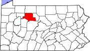
Elk County is a county in the Commonwealth of Pennsylvania. As of the 2020 United States census, the population was 30,990. Its county seat is Ridgway. The county was created on April 18, 1843, from parts of Jefferson, Clearfield, and McKean Counties. Elk County is named for the eastern elk that historically inhabited the region. Elk County is in the sparsely populated Pennsylvania Wilds region.

<span class="mw-page-title-main">Osage County, Missouri</span> County in Missouri, United States

Osage County is a county in the central part of the U.S. state of Missouri. As of the 2020 census, the population was 13,274. Its county seat is Linn. The county was organized January 29, 1841, and named from the Osage River.

<span class="mw-page-title-main">Elkhart County, Indiana</span> County in Indiana, United States

Elkhart County is a county located in the U.S. state of Indiana. As of 2020, the county's population was 207,047. The county seat is Goshen. Elkhart County is part of the Elkhart-Goshen Metropolitan Statistical Area, which in turn is part of the South Bend-Elkhart-Mishawaka Combined Statistical Area. It is also considered part of the broader region of Northern Indiana known as Michiana, and is 20 miles (32 km) east of South Bend, Indiana, 110 miles (180 km) east of Chicago, Illinois, and 150 miles (240 km) north of Indianapolis, Indiana. The area is referred to by locals as the recreation vehicle (RV) capital of the world and is known for its sizable Amish and Old Order Mennonite population.

<span class="mw-page-title-main">St. Joseph, Minnesota</span> City in Minnesota, United States

St. Joseph or Saint Joseph is a city in Stearns County, Minnesota, United States. The population was 7,029 at the 2020 census. It is home to the College of Saint Benedict.

<span class="mw-page-title-main">St. Michael, Minnesota</span> City in Minnesota, United States

St. Michael is a city in eastern Wright County, northwest of the Minneapolis-St Paul "Twin Cities" Metropolitan Area. The population was 18,235 at the 2020 census.

<span class="mw-page-title-main">Sugarcreek Township, Pennsylvania</span> Township in Pennsylvania, United States

Sugarcreek Township is a township in Armstrong County, Pennsylvania, United States. The population was 1,336 at the 2020 census, a decrease from the figure of 1,539 tabulated in 2010.

<span class="mw-page-title-main">DuBois, Pennsylvania</span> City in Pennsylvania, United States

DuBois is a city and the most populous community in Clearfield County, Pennsylvania, United States. DuBois is located approximately 100 miles (160 km) northeast of Pittsburgh. The population was 7,510 as of the 2020 census. It is the principal city in the DuBois, PA Micropolitan Statistical Area. DuBois is also one of two principal cities, the other being State College, that make up the larger State College-DuBois, PA Combined Statistical Area.

<span class="mw-page-title-main">Berwick, Pennsylvania</span> Borough in Pennsylvania, United States

Berwick is a borough in Columbia County, Pennsylvania, United States. It is part of Northeastern Pennsylvania and is located 28 miles (45 km) southwest of Wilkes-Barre. As of the 2020 census, Berwick had a population of 10,355. It is one of the two principal communities of the Bloomsburg–Berwick metropolitan area, which covers Columbia and Montour counties, and had a combined population of 85,562 at the 2010 census.

<span class="mw-page-title-main">Edgmont Township, Pennsylvania</span> Township in Pennsylvania, United States

Edgmont Township is a township in Delaware County, Pennsylvania, United States. Edgmont contains the unincorporated community of Gradyville. The population was 3,987 at the 2010 census.

<span class="mw-page-title-main">Linwood, Pennsylvania</span> Census-designated place in Pennsylvania, United States

Linwood is a census-designated place (CDP) in Delaware County, Pennsylvania, United States. The population was 3,281 at the 2010 census.

<span class="mw-page-title-main">Lower Chichester Township, Pennsylvania</span> Township in Pennsylvania, United States

Lower Chichester Township is a township in Delaware County, Pennsylvania, United States. The population was 3,469 at the 2010 census. It contains the census designated place of Linwood.

<span class="mw-page-title-main">Fox Township, Elk County, Pennsylvania</span> Township in Pennsylvania, United States

Fox Township is a township in Elk County, Pennsylvania, United States. The population was 3,577 at the 2020 census, down from 3,630 in 2010.

<span class="mw-page-title-main">Jay Township, Elk County, Pennsylvania</span> Township in Pennsylvania, United States

Jay Township is a township in Elk County, Pennsylvania, United States. The population was 1,961 at the 2020 census, down from 2,072 in 2010.

<span class="mw-page-title-main">Ridgway, Pennsylvania</span> Borough in Pennsylvania, United States

Ridgway is a borough in and the county seat of Elk County, Pennsylvania. As of the 2020 census it had a population of 4,039

<span class="mw-page-title-main">Sharon, Pennsylvania</span> City in Pennsylvania, United States

Sharon is a city in western Mercer County, Pennsylvania, United States. The city, located along the banks of the Shenango River on the state border with Ohio, is about 15 miles (24 km) northeast of Youngstown, about 65 miles (105 km) southeast of Cleveland and about 60 miles (97 km) northwest of Pittsburgh. The population was 13,147 at the 2020 census. It is part of the Hermitage micropolitan area.

<span class="mw-page-title-main">Kennedy Township, Allegheny County, Pennsylvania</span> Township in Pennsylvania, United States

Kennedy Township is a township in Allegheny County, Pennsylvania, United States, located 10 miles west of Pittsburgh and 12 miles east of Pittsburgh International Airport. The population was 8,701 at the 2020 United States Census.

<span class="mw-page-title-main">Upper Providence Township, Delaware County, Pennsylvania</span> Home rule municipality in Pennsylvania, United States

Upper Providence Township is a township in Delaware County, Pennsylvania, United States, located around and to the north of the borough of Media, and approximately 15 miles (24 km) west of center city Philadelphia. The population was 10,142 at the 2010 census. The township lies between Ridley Creek on the west and Crum Creek on the east. Most of Ridley Creek State Park is in the township, towards the northern edge. Zoning is 98% residential, 1% commercial and 1% industrial, with minimal space zoned to commercial business.

<span class="mw-page-title-main">St. Anthony, Minnesota</span> City in Minnesota, United States

St. Anthony, also known as Saint Anthony Village, is a city in Hennepin and Ramsey counties in the U.S. state of Minnesota. The population was 9,257 at the 2020 census, of whom 5,621 lived in the larger Hennepin County part of the city and 3,654 in the Ramsey County part. The city is run by a five-member council consisting of a mayor and four council members who serve four-year terms.

<span class="mw-page-title-main">Saint Marys Area School District</span> School district in Pennsylvania

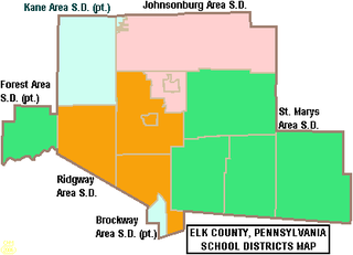
The Saint Marys Area School District is a midsized rural/suburban public school district serving parts of Elk County, Pennsylvania. It encompasses the city of St. Marys and the townships of Fox Township, Jay Township, and Benezette Township. Saint Marys Area School District encompasses approximately 341 square miles (880 km2). According to 2000 federal census data, the district serves a resident population of 20,557. In 2009, the district residents’ per capita income was $18,669, while the median family income was $48,121. In the Commonwealth, the median family income was $49,501 and the United States median family income was $49,445, in 2010.

<span class="mw-page-title-main">Benzinger Township, Elk County, Pennsylvania</span>

Benzinger Township was a township in Elk County, Pennsylvania. According to the 1990 census, it had a population of 8,509. It was settled in 1842 and created on December 18, 1845. On November 5, 1991, the citizens of Benzinger Township voted for the Borough of St. Marys and Benzinger Township to be consolidated into the City of St. Marys. The city was officially recognized by the Governor of Pennsylvania on June 18, 1992.

References

  1. "2019 U.S. Gazetteer Files". United States Census Bureau. Retrieved July 28, 2020.
  2. "Explore Census Data".
  3. 1 2 "Saint Marys City Code - History" (PDF). December 17, 2007. Archived from the original (PDF) on October 22, 2006. Retrieved July 22, 2008.
  4. "US Gazetteer files: 2010, 2000, and 1990". United States Census Bureau. February 12, 2011. Retrieved April 23, 2011.
  5. "Pennsylvania Watersheds".
  6. "Census of Population and Housing". U.S. Census Bureau. Retrieved December 11, 2013.
  7. "U.S. Census website". United States Census Bureau . Retrieved January 31, 2008.
  8. "Incorporated Places and Minor Civil Divisions Datasets: Subcounty Resident Population Estimates: April 1, 2010 to July 1, 2012". Population Estimates. U.S. Census Bureau. Archived from the original on June 11, 2013. Retrieved December 11, 2013.
  9. "U.S. Census website". United States Census Bureau . Retrieved May 14, 2011.
  10. "Elk County Catholic School System | the school with the cross".
  11. Prater, Tonya. "21 Incredible Faith-Based Attractions in the United States". Travel Inspired Living. Archived from the original on November 7, 2023. Retrieved November 7, 2023.
  12. "Oldest Benedictine convent in US closing in NW Pa". The Mercury. January 15, 2014. Retrieved January 23, 2024.
  13. "Steamlocomotive.com - Pennsylvania". steamlocomotive.info. Retrieved April 20, 2018.
  14. Riesenman, Joseph (1943). History of Northwestern Pennsylvania. New York: Lewis Historical Pub. Co. p. 400.