The Jubilee line is a London Underground line that runs between Stratford in east London and Stanmore in the suburban north-west, via the Docklands, South Bank and West End. Opened in 1979, it is the newest line on the Underground network, although some sections of track date back to 1932 and some stations to 1879.

The Piccadilly line is a deep-level London Underground line running from the north to the west of London. It has two branches, which split at Acton Town, and serves 53 stations. The line serves Heathrow Airport, and some of its stations are near tourist attractions such as Piccadilly Circus and Buckingham Palace. The District and Metropolitan lines share some sections of track with the Piccadilly line. Printed in dark blue on the Tube map, it is the fourth-busiest line on the Underground network, with over 210 million passenger journeys in 2011/12.

Kensington Gardens, once the private gardens of Kensington Palace, are among the Royal Parks of London. The gardens are shared by the City of Westminster and the Royal Borough of Kensington and Chelsea and sit immediately to the west of Hyde Park, in western central London known as the West End. The gardens cover an area of 107 hectares. The open spaces of Kensington Gardens, Hyde Park, Green Park, and St. James's Park together form an almost continuous "green lung" in the heart of London. Kensington Gardens are Grade I listed on the Register of Historic Parks and Gardens.

Greenwich Park is a former hunting park in Greenwich and one of the largest single green spaces in south-east London. One of the Royal Parks of London, and the first to be enclosed, it covers 74 hectares, and is part of the Greenwich World Heritage Site. It commands views over the River Thames, the Isle of Dogs and the City of London.

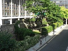
The London Wall is a defensive wall first built by the Romans around the strategically important port town of Londinium in c. AD 200, as well as the name of a modern street in the City of London, England.

West Norwood Cemetery is a 40-acre (16 ha) rural cemetery in West Norwood in London, England. It was also known as the South Metropolitan Cemetery. One of the first private landscaped cemeteries in London, it is one of the "Magnificent Seven" cemeteries of London, and is a site of major historical, architectural and ecological interest.

Llantwit Major is a town and community in Wales on the Bristol Channel coast. It is one of four towns in the Vale of Glamorgan, with the third largest population after Barry and Penarth, and ahead of Cowbridge. It is 4+1⁄2 miles (7.2 km) from Cowbridge, 9 miles (14 km) from Bridgend, 10 miles (16 km) from Barry, and 15 miles (24 km) from Cardiff. It had a population of 9,530 in 2021.

Hampton Court Park, also known as Home Park, is a walled royal park managed by the Historic Royal Palaces. The park lies between the gardens of Hampton Court Palace and Kingston upon Thames and Surbiton in south west London, England, mostly within the post town of East Molesey, but with its eastern extremity within the post town of Kingston. In 2014, part of the park was designated a biological Site of Special Scientific Interest. It takes up most of the final (lowest) meander of the non-tidal reaches of the River Thames and is mainly divided between a golf course, meadows interspersed with trees used for deer, seasonal horse grazing and wildlife. A corner of the park is used annually for the Hampton Court Flower Show and the part nearest to the palace has the Long Water — an early set of hydro-engineered ponds or lakes, fed by water from the distant River Colne, as are the bodies of water in the neighbouring park, Bushy Park.

Coade stone or Lithodipyra or Lithodipra is stoneware that was often described as an artificial stone in the late 18th and early 19th centuries. It was used for moulding neoclassical statues, architectural decorations and garden ornaments of the highest quality that remain virtually weatherproof today.

Ravenscourt Park or RCP is an 8.3 hectares public park and garden located in the London Borough of Hammersmith and Fulham, England. It is one of the Borough's flagship parks, having won a Green Flag Award. Stamford Brook and Ravenscourt Park tube stations are close by.

Bassishaw is a ward in the City of London. Small, it is bounded by wards: Coleman Street, east; Cheap, south; Cripplegate, north; Aldersgate, west.

St George's Fields are a former burial ground of St George's, Hanover Square, lying between Connaught Street and Bayswater Road in Tyburnia deconsecrated and sold off by the Church Commissioners in the 1970s to be built upon by The Utopian Housing Association, a housing trust.

St Alphege or St Alphage London Wall was a church in Bassishaw Ward in the City of London, built directly upon London Wall. It was also known as St Alphege Cripplegate, from its proximity to Cripplegate. It is now operated as St Alphege Gardens.

St Botolph's, Billingsgate was a Church of England parish church in London. Of medieval origin, it was located in the Billingsgate ward of the City of London and destroyed by the Great Fire of London in 1666.

Panshanger was a large country house located between the outer edge of Hertford and Welwyn Garden City in Hertfordshire, England.
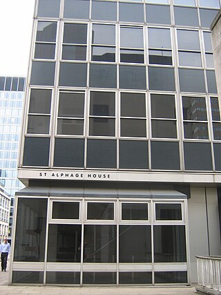
St Alphage House was a 1960s office block on Fore Street in the City of London. It was built by the developer Maurice Wingate to a design by Maurice Sanders Associates. It was named after Saint Alphege and the church of St Alphage London Wall, whose ruins stand below where the building stood. It was built as part of the redevelopment of London Wall, and was one of a series of similar blocks built between 1957 and 1976.

St James' Church, Norlands, is a historic listed church in London, United Kingdom. It is affiliated with the Church of England. It was designed by architects Lewis Vulliamy and Robert Jewell Withers, and its construction was completed in 1845. The church was consecrated on 17 July of the same year. It is listed as Grade II by English Heritage.

Lawrence Lane is a street in the City of London that runs from Trump Street in the south to Gresham Street in the north. Its final section in the north is pedestrianised. An alley also joins it to King Street in the north. It once ran south to join Cheapside but that end was blocked following post-Second World War rebuilding. It was known as St Lawrence Lane from the 13th to the 18th centuries due to its proximity to the church of St Lawrence Jewry and until King Street was built was the main route from Cheapside to the London Guildhall.

The Grade I listed building Walpole House is the largest, finest, and most complicated of the grand houses on Chiswick Mall, a waterfront street in the oldest part of Chiswick. Both the front wrought-iron screen and gate, and the back boundary wall, are Grade II listed.

Bastion House is an office block in the Barbican area of the City of London, England. The building was designed by Powell & Moya and completed in 1976. It has 17 storeys.