
The Quantock Hills west of Bridgwater in Somerset, England, consist of heathland, oak woodlands, ancient parklands and agricultural land. They were England's first Area of Outstanding Natural Beauty, designated in 1956.

Exmoor is loosely defined as an area of hilly open moorland in west Somerset and north Devon in South West England. It is named after the River Exe, the source of which is situated in the centre of the area, two miles north-west of Simonsbath. Exmoor is more precisely defined as the area of the former ancient royal hunting forest, also called Exmoor, which was officially surveyed 1815–1818 as 18,810 acres (7,610 ha) in extent. The moor has given its name to a National Park, which includes the Brendon Hills, the East Lyn Valley, the Vale of Porlock and 55 km (34 mi) of the Bristol Channel coast. The total area of the Exmoor National Park is 692.8 km2 (267.5 sq mi), of which 71% is in Somerset and 29% in Devon.

West Somerset was a local government district in the English county of Somerset. The council covered a largely rural area, with a population of 34,900 in an area of 740 square kilometres (290 sq mi); it was the least populous non-unitary district in England. According to figures released by the Office for National Statistics in 2009, the population of West Somerset has the oldest average age in the United Kingdom at 52. The largest centres of population are the coastal towns of Minehead and Watchet (4,400).

Dulverton is a small town and civil parish in west Somerset, England, near the border with Devon. The town had a population of 1,408 at the 2011 Census. The parish includes the hamlets of Battleton and Ashwick which is located approximately 3.5 miles (5.6 km) north west of Dulverton. To the west of the hamlet lies Ashwick House, built in the Edwardian style in 1901. Also nearby is the estate of Northmoor, formerly a seat of Sir Frederick Wills, 1st Baronet of Northmoor, one of the four Wills Baronetcys, and the founders of the Imperial Tobacco Company. In 1929 Sir Frederick's son & heir, Sir Gilbert Wills, 2nd Baronet, was raised to the peerage as Baron Dulverton, whose principal seat was at Batsford Park, near Batsford, Gloucestershire.

Dunkery Beacon at the summit of Dunkery Hill is the highest point on Exmoor and in Somerset, England. It is also the highest point in southern England outside of Dartmoor.
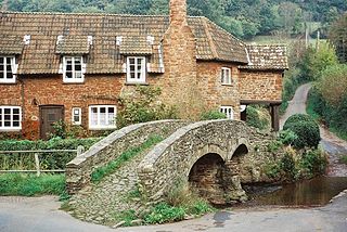
Allerford is a village in the county of Somerset, England, located within Exmoor National Park, and is part of the parish of Selworthy in the district of Somerset West and Taunton. It appears in Domesday Book as "Alresford – forda Ralph de Limesy Mill".

West Quantoxhead is a small village and civil parish in the Somerset West and Taunton district of Somerset, England. It lies on the route of the Coleridge Way and on the A39 road at the foot of the Quantock Hills, 3 miles (5 km) from East Quantoxhead, 2.5 miles (4 km) from Williton and equidistant from Bridgwater and Taunton. The parish includes the hamlets of Weacombe and Lower Weacombe.

Holnicote in the parish of Selworthy, West Somerset, England, is a historic estate consisting of 12,420 acres of land, much situated within the Exmoor National Park.

There have been three baronetcies created for people with the surname Hood, one in the Baronetage of Great Britain and two in the Baronetage of the United Kingdom. The first Baronet of the first creation was made Viscount Hood, while the fourth Baronet of the second creation was made Baron St Audries.

Luccombe or Luckham is a village and civil parish in the Exmoor National Park in the English county of Somerset. It at the foot of the moor's highest hill, the 1,750 feet (533 m) Dunkery Beacon, and is about one mile south of the A39 road between Porlock and Minehead. Administratively it forms part of the district of Somerset West and Taunton. The parish includes the hamlets of Stoke Pero and Horner, as well as the former hamlet of Wilmersham.

Simonsbath is a small village high on Exmoor in the English county of Somerset. It is the principal settlement in the Exmoor civil parish, which is the largest and most sparsely populated civil parish on Exmoor, covering nearly 32 square miles (83 km2) but with a population, at the time of the 2001 census, of 203 in 78 households, reducing to 156 at the 2011 Census. The River Exe rises from a valley to the north, and the River Barle runs through the village and is crossed by a triple-arched medieval bridge that was extensively repaired after floods in 1952.

East Quantoxhead is a village in the district of Somerset West and Taunton, 3 miles (5 km) from West Quantoxhead, 4 miles (6 km) east of Williton, and 13 miles (21 km) west of Bridgwater, within the Quantock Hills Area of Outstanding Natural Beauty in Somerset, England.

Selworthy is a small village and civil parish 5 kilometres (3 mi) from Minehead in Somerset, England. It is located in the National Trust's Holnicote Estate on the northern fringes of Exmoor. The parish includes the hamlets of Bossington, Tivington, Lynch, Brandish Street and Allerford.

Redlynch is a village and former manor in the civil parish of Bruton, in the South Somerset district of Somerset, England.

Pixton Park is a country house in the parish of Dulverton, Somerset, England. It is associated with at least three historically significant families, successively by descent: Acland, amongst the largest landowners in the Westcountry; Herbert, politicians and diplomats; and Waugh, writers. The present grade II* listed Georgian mansion house was built circa 1760 by the Acland family and in 1870 was altered by Henry Herbert, 4th Earl of Carnarvon (1831–1890). Although Pixton Park is situated within the manor of Dulverton, the manorial chapel relating to Pixton is situated not at Dulverton but within the Church of St Nicholas, Brushford, across the River Barle, as the lordship of the manor of Dulverton was held from 1568 by the Sydenham family seated at Combe House, on the opposite side of the River Barle to Dulverton and Pixton.
Dame Elizabeth Periam Gass, Lady Gass, was Lord-Lieutenant of Somerset from 1998 to 2015.

The Dovecot At Blackford Farm in Selworthy on Exmoor within the English county of Somerset was probably built in the 11th century. It is a Grade II* listed building, and scheduled monument.

The Anglican Church of St Mary Magdelene in Exford, Somerset, England was built in the 15th century. It is a Grade II* listed building.
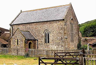
The Anglican Lynch Chapel Of Ease in West Lynch, Selworthy, Somerset, England was built around 1530. It is a Grade II* listed building.

The Church of St Etheldreda, also known as the Church of St Audries, is a Church of England parish church in West Quantoxhead, Somerset, England. Designed by John Norton, it was built in 1854-56 and is a Grade II* listed building.

