
Nottinghamshire is a ceremonial county in the East Midlands of England. The county borders South Yorkshire to the north-west, Lincolnshire to the east, Leicestershire to the south, and Derbyshire to the west. The largest settlement is the city of Nottingham (323,632).

Newark and Sherwood is a local government district in Nottinghamshire, England. It is the largest district by area in the county. The council is based in Newark-on-Trent, the area's largest town. The district also includes the towns of Southwell and Ollerton along with a large rural area containing many villages. Much of the district lies within the ancient Sherwood Forest and there are also extensive forestry plantations in the area.

Nottinghamshire is a county that is situated in the East Midlands of England. The county has history within the Palaeolithic period, dating anywhere between 500,000 and 10,000 BCE, as well as early Anglo-Saxon communities, dating to 600 CE. Furthermore, the county has significance in the political aspects of English history, particularly within intercommunal fighting, and its economics is historically centred around coal and textiles.

Wellow is a village in Nottinghamshire, England. According to the 2001 census it had a population of 444, increasing to 470 at the 2011 census, but falling slightly to 463 at the 2021 census.

Ollerton and Boughton is a civil parish in the Newark and Sherwood district of Nottinghamshire, England. The main settlements are the town of Ollerton and the villages of New Ollerton and Boughton. The civil parish was formed in 1996, when the civil parishes of Ollerton and Boughton were merged. The population of the civil parish at the time of the 2011 census was recorded as 9,840, and this increased to 11,089 residents at the 2021 census.
Bassetlaw was a wapentake in the English county of Nottinghamshire. The wapentake covered an area in the north of the county, roughly equivalent to the modern Bassetlaw local government district. The wapentake was divided into the divisions of Hatfield, North Clay and South Clay.

Ollerton Town Football Club is a football club based in Ollerton, Nottinghamshire, England. The men's team play in the Northern Counties East League Division One whilst the ladies team plays in the East Midlands Women's Regional Football League.

Rufford Abbey is a country estate in Rufford, Nottinghamshire, England, two miles (4 km) south of Ollerton. Originally a Cistercian abbey, it was converted to a country house in the 16th century after King Henry VIII’s dissolution of the monasteries. Part of the house was demolished in the 20th century, but the remains, standing in 150 acres of park and woodland, are open to the public as Rufford Country Park. Part of the park is a local nature reserve.

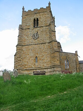
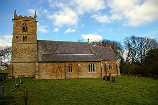
Walesby is a village and civil parish in Nottinghamshire, England. At the time of the 2001 census it had a population of 1,255 people, increasing slightly to 1,266 at the 2011 census, and dropping to 1,218 at the 2021 census. It is located 16 miles (26 km) north of Newark. The parish church of St Edmund is Perpendicular in style.
Walesby is a village and civil parish in the West Lindsey district of Lincolnshire, England. The population of the civil parish at the 2011 census was 249. It lies in the Lincolnshire Wolds, 3 miles (5 km) north-east from Market Rasen and 7 miles (11 km) south from Caistor. Tealby parish lies to the south-east. The parish covers about 3,600 acres (15 km2) and includes the hamlets of Risby and Otby.
St. Edmund's Church or similar variations can refer to numerous churches:

Brookenby Church is located in Brookenby, Lincolnshire, England. A member of the Church of England, it forms part of the Walesby group of churches, which also includes churches in Claxby, Kirmond le Mire, Normanby le Wold, North Willingham, Stainton le Vale, Tealby and Walesby. This group of Churches is within the Diocese of Lincoln. Dedicated to the archangel Saint Michael, Brookenby church was established in the 1990s and is housed in the West wing of a former Officers Mess building.

Claxby, or Claxby by Normanby, is a village and civil parish in the West Lindsey district of Lincolnshire, England. The population of the civil parish taken at the 2011 census was 221. It is situated approximately 4 miles (6 km) north from the town of Market Rasen and 5 miles (8 km) south from the town of Caistor.
Normanby le Wold is a village and civil parish in the West Lindsey district of Lincolnshire, England. It is in the Lincolnshire Wolds, an Area of Outstanding Natural Beauty, and about 5 miles (8.0 km) south from the town of Caistor, and 17 miles (27 km) north-east from the city and county town of Lincoln. It is in the civil parish of Claxby by Normanby.

North Willingham is a village and civil parish in the West Lindsey district of Lincolnshire, England. The population of the civil parish was at 181 during the 2011 census. It is situated 3.5 miles (6 km) east from the town of Market Rasen on the A631 road between Market Rasen and Louth.
The Rufford Charters were grants of land and grants of Regalian rights over land, which created an extra-parochial liberty, known as the Liberty of Rufford in the County of Nottinghamshire in England. It is defined as an area in which regalian rights were exercised by the Cistercian monks of Rufford Abbey.

West Markham or Markham Clinton is a village and civil parish 23 miles (37 km) north east of Nottingham, in the Bassetlaw district, in the county of Nottinghamshire, England. In the 2011 census, the parish had a population of 170, and this increased marginally to 175 residents at the 2021 census. The parish touches Bevercotes, West Drayton, East Markham, Bothamsall, Walesby and Tuxford. The A1 previously went through the village but its now been bypassed.

