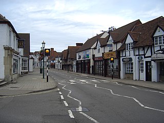
Knowle is a large village situated 3 miles (5 km) east-southeast of the town of Solihull, West Midlands, England. Knowle lies within the Arden area of the historic county boundaries of Warwickshire, and since 1974 it has been part of the Metropolitan Borough of Solihull within the West Midlands. It lies 2.5 miles from the Warwickshire border and had a recorded population of 10,678.
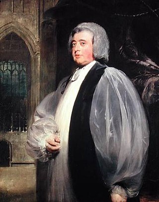
John Moore was Archbishop of Canterbury in the Church of England.

The Metropolitan Borough of Solihull is a metropolitan borough in West Midlands county, England. It is named after its largest town, Solihull, from which Solihull Metropolitan Borough Council is based. For Eurostat purposes it is a NUTS 3 region and is one of seven boroughs or unitary districts that comprise the "West Midlands" NUTS 2 region. Much of the large residential population in the north of the borough centres on the communities of Castle Bromwich, Kingshurst, Marston Green and Smith's Wood as well as the towns of Chelmsley Wood and Fordbridge. In the south are the towns of Shirley and Solihull, as well as the large villages of Knowle, Dorridge, Meriden and Balsall Common.

Acocks Green is an area and ward of southeast Birmingham, England. It is named after the Acock family, who built a large house there in 1370. Acocks Green is one of four wards making up Yardley formal district. It is occasionally spelled "Acock's Green". It has frequently been noted on lists of unusual place names.

Meriden is a village and civil parish in the Metropolitan Borough of Solihull, West Midlands, England. Historically, it is part of Warwickshire and lies between the cities of Birmingham and Coventry. It is located close to the Warwickshire border within a green belt of the countryside known as the Meriden Gap and is in the ecclesiastical parish of the Diocese of Coventry. The village is 6.75 miles east-northeast of Solihull, 6.5 miles west-northwest of Coventry and 4.5 miles east-southeast of Birmingham Airport. Birmingham city centre is 12.5 miles east-northeast of the village. Known as "Alspath" in the Domesday Book, it was historically thought to be the geographical centre of England until the early 2000s, though after an analysis by the Ordnance Survey this was proved to be incorrect.

Shirley is a town in the Metropolitan Borough of Solihull, in the West Midlands, England. Historically part of Warwickshire, neighbouring districts include Shirley Heath, Sharmans Cross, Solihull Lodge, Monkspath,Cheswick Green Cranmore and the Hall Green district of Birmingham.
Lapworth is a village and civil parish in Warwickshire, England, which had a population of 2,100 according to the 2001 census; this had fallen to 1,828 at the 2011 Census. It lies six miles (10 km) south of Solihull and ten miles (16 km) northwest of Warwick, and incorporates the hamlet of Kingswood. Lapworth boasts a historic church, the Church of St Mary the Virgin, a chapel. Two National Trust sites are nearby: Baddesley Clinton, a medieval moated manor house and garden located in the village of Baddesley Clinton; and Packwood House, a Tudor manor house and yew garden with over 100 trees in Packwood.
Olton is an area/suburban village within the Metropolitan Borough of Solihull in the West Midlands, England. In the 13th century, the Lords of the Manor moved their seat and formed a new settlement, at the junction of two major roads. It was then that Ulverlei was being referred to as ‘Oulton’ to distinguish itself from nearby Solihull. Historically within the county of Warwickshire, the village has gradually become contiguous with Solihull to the southeast, though it retains the character of a large independent village.
Bickenhill is a small village in the civil parish of Bickenhill and Marston Green, in the Solihull district, in the county of the West Midlands, England, on the eastern fringe of the West Midlands conurbation. Bickenhill is home to Birmingham Airport. Bickenhill is also a ward. It is in the historic county of Warwickshire.

Hockley Heath is a large village and civil parish in the Arden area mostly within the Metropolitan Borough of Solihull, West Midlands, England, incorporating the hamlet of Nuthurst, with a history dating back to the year 705 AD as a wood owned by Worcester Cathedral. The parish, known as Nuthurst cum Hockley Heath, is to the south of the West Midlands conurbation, 12 miles (19 km) southeast of Birmingham 5.5 miles (8.9 km) from Solihull town centre and 12.5 miles (20.1 km) north of Stratford-upon-Avon. The village forms part of the border with Warwickshire and the District of Stratford-on-Avon to the south, with some parts of the village on either side of the border. According to the 2001 census, the parish had a population of 6,771, being measured at the 2011 Census as 2,038.

Berkswell is a village and civil parish in the Metropolitan Borough of Solihull, county of West Midlands, England. Historically in Warwickshire, Berkswell is situated in the rural east of the borough, approximately 2 miles (3.2 km) west of the western city boundary of Coventry, at Eastern Green. It is situated about 6.5 miles (10.5 km) west of Coventry city centre, 8.5 miles (13.7 km) east of central Solihull, 2.5 miles (4.0 km) south of Meriden and 2 miles (3.2 km) north of Balsall Common.

Julius Alfred Chatwin FRIBA, ARBS, FSAScot was a British architect. He was involved with the building and modification of many churches in Birmingham, and practised both Neo-Gothic and Neo-Classical styles. His designs always included all of the carvings and internal fittings.
Solihull is a market town, and seat of the wider Metropolitan Borough of Solihull in the West Midlands County, England. Solihull is situated on the River Blythe in the Forest of Arden area. The town had a population of 126,577 at the 2021 Census, and its wider borough had a population of 216,240
Haseley is a small village and former civil parish in Warwickshire, England. It is four miles north-west of the county town of Warwick and nine miles (14.5 km) south-east of Solihull, now in the parish of Beausale, Haseley, Honiley and Wroxall, created on 1 April 2007. The village is on the A4177 and is easily accessible as it is only five miles (8 km) from the M40 motorway. Haseley proper, along with Haseley Knob, Haseley Green and Waste Green, consists mainly of detached houses spread over a large area, giving the parish a very low housing density. There were, according to the 2001 census, 207 residents living in 92 dwellings. It is an affluent area, with an average house price of around £277,000. Due to this and its proximity to the tourist towns of Warwick and Stratford upon Avon there are several large and highly rated hotels around the village.

St James' by the Park is an Anglican parish church which meets in Shirley, Southampton. The church owns two buildings, St James' and St John's churches. St James' is a Grade II listed building.
Faxton is an abandoned village and chapelry in the county of Northamptonshire in England. Nearby are the villages of Old, Lamport and Mawsley and the Northampton & Lamport Railway.

Ettington is a village and civil parish about 5.5 miles (9 km) south-east of Stratford-upon-Avon in Warwickshire, England. The 2011 Census recorded the parish's population as 1,171. The present village is on the A422 main road linking Stratford and Banbury. The A429 main road linking Warwick and Cirencester used to run through the village, and now uses a bypass just west of it. The Fosse Way Roman road crosses the A422 0.6 miles (1 km) east of the village.

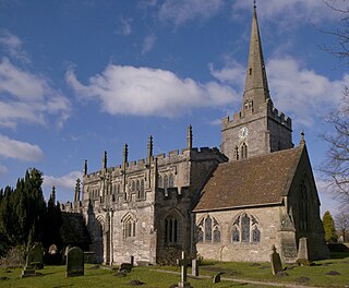
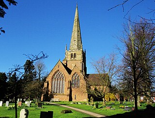
St Alphege Church, Solihull, is a medieval parish church in the Church of England in Solihull, West Midlands.
Major's Green is a village in the Wythall parish of Bromsgrove district and is the northeastern-most settlement in the county of Worcestershire, England.

