
Harold Wood is a suburban neighbourhood of Romford in the London Borough of Havering. It is situated 16.5 miles (26.6 km) east-northeast of Charing Cross close to the Essex boundary.

Hornchurch is a suburban town in East London, England, and part of the London Borough of Havering. It is located 15.2 miles (24.5 km) east-northeast of Charing Cross. It comprises a number of shopping streets and a large residential area. It historically formed a large ancient parish in the county of Essex that became the manor and liberty of Havering. The economic history of Hornchurch is underpinned by a shift away from agriculture to other industries with the growing significance of nearby Romford as a market town and centre of administration. As part of the suburban growth of London in the 20th century, Hornchurch significantly expanded and increased in population, becoming an urban district in 1926 and has formed part of Greater London since 1965. It is the location of Queen's Theatre, Havering Sixth Form College and Havering College of Further and Higher Education.

Romford is a large town in East London and the administrative centre of the London Borough of Havering. It is located 14.1 miles (22.7 km) northeast of Charing Cross and is one of the major metropolitan centres identified in the London Plan. Historically, Romford was a market town in the county of Essex, and it formed the administrative centre of the liberty of Havering before that liberty was dissolved in 1892. Good road links to London and the opening of the railway station in 1839 were key to the development of the town. The economic history of Romford is characterised by a shift from agriculture to light industry and then to retail and commerce. Throughout the 20th century, along with other London suburbs, Romford significantly expanded and increased in population, becoming a municipal borough in 1937. Romford was part of Essex until 1965, when it became part of Greater London. Today, it is one of the largest commercial, retail, entertainment and leisure districts in London and has a well-developed night-time economy as well. Its population, as of 2011, was 122,854.

Upminster is a suburban town in East London, England, within the London Borough of Havering. Located 16.5 miles (26.6 km) east-northeast of Charing Cross, it is one of the district centres identified for development in the London Plan.

The London Borough of Havering in East London, England, forms part of Outer London. It has a population of 259,552 inhabitants; the principal town is Romford, while other communities are Hornchurch, Upminster, Collier Row and Rainham. The borough is mainly suburban, with large areas of protected open space. Romford is a major retail and night time entertainment centre, and to the south the borough extends into the London Riverside redevelopment area of the Thames Gateway. The name Havering is a reference to the Royal Liberty of Havering which occupied the area for several centuries. The local authority is Havering London Borough Council. It is the easternmost London borough.
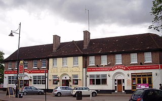
Elm Park is a suburban planned community in East London within the London Borough of Havering. Located 14.3 miles (23.0 km) east-northeast of Charing Cross, it is identified as a district centre in the London Plan with several streets of shops and a priority for regeneration. Prior to the construction of the extensive Elm Park Garden City development in the 1930s it was a scattered settlement of farms in the south of the parish of Hornchurch. Elm Park has been connected to central London by the electrified District line service since 1935 and the planned development of the area formed part of the interwar private housing boom that was interrupted by World War II. After the war Elm Park expanded with social housing and it has formed part of Greater London since 1965.

Ardleigh Green is an area in east London, England, within the London Borough of Havering. It is 15.5 miles (25 km) east-northeast of Charing Cross. This part of London is predominantly residential.
Gidea Park is a neighbourhood in the east of Romford in the London Borough of Havering, south-east England.

Harold Hill is a suburban area in the London Borough of Havering, East London. 16.6 miles (26.7 km) northeast of Charing Cross. It is a district centre in the London Plan. The name refers to Harold Godwinson who held the manor of Havering-atte-Bower. It is peripheral to London, forming an eastern edge of the urban sprawl.

Chadwell Heath is an area in east London, England. It is situated on the boundary of the London Borough of Barking and Dagenham and the London Borough of Redbridge, around 2 miles (3.2 km) west of Romford and 4 miles (6.4 km) east of Ilford, and 12 miles (19 km) north-east of Charing Cross.
The Royal Liberty School is a secondary school for boys aged 11 to 16, located in Gidea Park in the London Borough of Havering, England.

Knighton is a residential suburban area of Leicester, situated between Clarendon Park to the north, Stoneygate to the east, Oadby and Wigston to the south and the Saffron Lane estate to the west.

Romford is a constituency represented in the House of Commons of the UK Parliament since 2001 by Andrew Rosindell, a Conservative. It was created in 1885.

Hackney was a parish in the historic county of Middlesex. The parish church of St John-at-Hackney was built in 1789, replacing the nearby former 16th-century parish church dedicated to St Augustine. The original tower of that church was retained to hold the bells until the new church could be strengthened; the bells were finally removed to the new St John's in 1854. See details of other, more modern, churches within the original parish boundaries below.
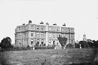
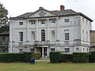
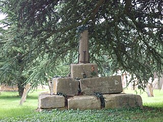
Gidea Hall was a manor house in Gidea Park, the historic parish and Royal liberty of Havering-atte-Bower, whose former area today is part of the north-eastern extremity of Greater London.
Edenham is a village and civil parish in the South Kesteven district of Lincolnshire, England. It is approximately 3 miles (5 km) north-west of Bourne, and on the A151 road. While the civil parish is called 'Edenham', the parish council is called Edenham, Grimsthorpe, Elsthorpe & Scottlethorpe Parish Council. The population of the civil parish at the 2011 census was 291.

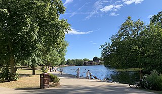
Raphael Park is a public park in Gidea Park, Romford, in the London Borough of Havering, United Kingdom. It is one of a series of parks stretching northwards from the railway line between Romford and Gidea Park. The park is commonly known as Raphael's Park by locals.

Romford Garden Suburb is a late-Edwardian housing development in Gidea Park, in the London Borough of Havering. The object of the new suburb, which was built on land belonging to Gidea Hall, then occupied by the Liberal politician Herbert Raphael, was, according to his parliamentary colleague John Burns, to "provide families with a well-built, modern home regardless of class or status" and "to bring the towns into the country and the country into the towns".

St Michael's Church is a Church of England parish church on the Romford Road in Manor Park, east London.

