
William Butterfield was a Gothic Revival architect and associated with the Oxford Movement. He is noted for his use of polychromy.
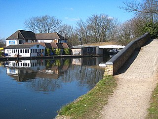
Cowley is a village contiguous with the town of Uxbridge in the London Borough of Hillingdon. A largely suburban village with 16 listed buildings, Cowley is 15.4 miles (24.8 km) west of Charing Cross, bordered to the west by Uxbridge Moor in the Green Belt and the River Colne, forming the border with Buckinghamshire. Cowley was an ancient parish in the historic county of Middlesex.

Wood Green is a suburban district in the borough of Haringey in London, England. Its postal district is N22, with parts in N8 or N15. The London Plan identifies it as one of the metropolitan centres in Greater London, and today it forms a major commercial district of North London.
Earley is a town and civil parish in the Borough of Wokingham, Berkshire, England. Along with the neighbouring town of Woodley, the Office for National Statistics places Earley within the Reading/Wokingham Urban Area; for the purposes of local government it falls within the Borough of Wokingham, outside the area of Reading Borough Council. Its name is sometimes spelt Erleigh or Erlegh and consists of a number of smaller areas, including Maiden Erlegh and Lower Earley, and lies some 3 miles (5 km) south and east of the centre of Reading, and some 4 miles (6 km) northwest of Wokingham. It had a population of 32,036 at the 2011 Census.

West Drayton is a suburban town in the London Borough of Hillingdon. It was an ancient parish in the county of Middlesex and from 1929 was part of the Yiewsley and West Drayton Urban District, which became part of Greater London in 1965. The settlement is near the Colne Valley Regional Park and its centre lies 1.9 miles (3 km) north of Heathrow Airport.
Easterton is a village and civil parish in Wiltshire, England, 4 miles (6.4 km) south of Devizes. The parish includes the hamlets of Easterton Sands and Eastcott.

Burland is a village and civil parish in the unitary authority of Cheshire East and the ceremonial county of Cheshire, England, about 2½ miles west of Nantwich. The civil parish also includes the small settlements of Burland Lower Green, Burland Upper Green, Hollin Green and Stoneley Green, as well as parts of Gradeley Green and Swanley. The eastern part of the village of Ravensmoor also falls within the civil parish.

Broxbourne is a town and former civil parish, now in the unparished area of Hoddesdon, in the Borough of Broxbourne district, in Hertfordshire, England, with a population of 15,303 at the 2011 Census. It is located to the south of Hoddesdon and to the north of Cheshunt, 17.1 miles (27.5 km) north of London. The town is near the River Lea, which forms the boundary with Essex, and 4.5 miles (7.2 km) north of the M25 motorway. To the west of the town are Broxbourne Woods, a national nature reserve. The Prime Meridian runs just east of Broxbourne.

Wonersh is a village and civil parish in the Waverley district of Surrey, England and Surrey Hills Area of Outstanding Natural Beauty. Wonersh contains three Conservation Areas and spans an area three to six miles SSE of Guildford.

St Thomas is an area of Exeter and formerly a 3,700-acre (15 km2) civil parish and registration district in Devon, England, on the western side of the River Exe, connected to Exeter by Exe Bridge. It has a number of pubs, places of worship, several schools and a large shopping precinct. The population, according to the 2001 census, is 6,246, increasing to 6,455 at the 2011 Census.

West Green is an area of north London, England, in the United Kingdom and part of the London Borough of Haringey. It is located 5.7 miles (9.22 km) north of Charing Cross.

Sutton is a village and civil parish near Dover in Kent, England. In 1935 this village became a parish when the small settlements of Studdal, Sutton, Ashley, Little Mongeham and Maydensole joined to become the Parish of Sutton-by-Dover. Prior to this Sutton has had a vast history of agricultural practices, which has helped sustain the village into the parish it is today. The quoted population includes the villages of East and West Studdal plus Swingate and the hamlet of Little Mongeham.

Minshull Vernon is a hamlet and civil parish in the unitary authority of Cheshire East and the ceremonial county of Cheshire, England. The hamlet lies 3 miles (5 km) to the north west of Crewe, south east of Winsford and south west of Middlewich. The parish also includes the small settlements of Bradfield Green, Eardswick, Hoolgrave, Minshull Hill, Walley's Green and Weaver Bank. The total population of the civil parish is somewhat over 200, measured at 391 in the Census 2011. Nearby villages include Church Minshull, Warmingham and Wimboldsley.

Stapeley is a hamlet and civil parish in the unitary authority of Cheshire East and the ceremonial county of Cheshire, England. The hamlet lies 2¼ miles to the south east of Nantwich. The parish also includes the small settlements of Broad Lane and Butt Green, and parts of Artle Brook, Haymoor Green and Howbeck Bank, as well as a recent residential development north of the A5301 adjacent to Nantwich. In 2008, the total population was estimated to be a little under 3000, increasing to 3,336 at the 2011 Census. Nearby villages include Shavington, Willaston and Wybunbury.

St. Peter the Apostle Church was a Roman Catholic church located within the Archdiocese of Baltimore in Baltimore, Maryland. Constructed at the northwest corner of Hollins and South Poppleton Streets and, it was often referred to as "The Mother Church of West Baltimore."

St Peter's, Hammersmith, is a Church of England parish church. It is a Grade II* listed church, and the oldest church in Hammersmith.

Tottenham is a town in North London, England, within the London Borough of Haringey. It is located in the ceremonial county of Greater London. Tottenham is centred 6 mi (10 km) north-northeast of Charing Cross, bordering Edmonton to the north, Walthamstow, across the River Lea, to the east, and Stamford Hill to the south, with Wood Green and Harringay to the west.

St Thomas the Apostle is a Church of England church, which is situated along Boston Road in Hanwell, in the London Borough of Ealing. Designed by Sir Edward Maufe, It forms part of the Diocese of London and can hold 428 people. English Heritage has listed it as a Grade II* building.
Hilldale is civil parish in the West Lancashire district of Lancashire, England, containing the village of Hill Dale and the neighbouring hamlet of Andertons Mill. Formerly part of Wrightington, Hilldale became a separate civil parish in 1999. As of 2011, Hilldale has a population of 581.

St Mark's Church, Silvertown or St Mark's Church, Victoria Docks is a former church building in Silvertown in east London, located on North Woolwich Road. It takes one of its names from the nearby Royal Docks. It was listed as Grade II* in 1971 and now houses the Brick Lane Music Hall.

