
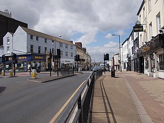
St Sepulchre Gate is a pedestrianised street in the city centre of Doncaster, in South Yorkshire, England.
St Sepulchre Gate is a pedestrianised street in the city centre of Doncaster, in South Yorkshire, England.
The street lay outside the Roman and Saxon settlements of Doncaster. It emerged as the main route into the town from the south-west. It was built up in 12th century, around which time, one of the town's four stone gates was constructed to regulate access to the expanded area of the town. Part of the street outside the wall was also built up, as an early suburb of the town. [1] [2] In 1781, a Roman altar was found on the street. [3] In 1557, the Hospital of St Thomas almshouses were built on the road, being rebuilt in the 1730s and finally demolished in 1963. [4]
The road became one of the main shopping streets of the town; Doncaster Metropolitan Borough Council describe it as currently the principal shopping street. [3] In 1902, a tramway was constructed along the road, operating until 1931. [5] The street was widened in the early-20th century. [3] In 1968, the Arndale Centre (later known as the Frenchgate Centre) opened on the north-west side of the street. [6]
The road runs south-west, from the junction of Baxter Gate, Frenchgate and High Street, to Trafford Way. Beyond the main road, its former route continues as St Sepulchre Gate West, terminating at a junction with St James's Bridge. On its south-east side, it has junctions with Printing Office Street, Duke Street, and Spring Gardens, while on its north-west side, it has junctions with West Laith Gate, and the western section has a junction with West Street. [3]
Notable buildings on the street include 33 St Sepulchre Gate, an art deco shop and pub built about 1930, [7] and Danum House, a 5-storey office block and shop, built for the Doncaster Co-operative Society. [8] On St Sepulchre Street West is St James' Church, built in 1858. [9]

Doncaster is a city in South Yorkshire, England. Named after the River Don, it is the administrative centre of the larger City of Doncaster. The city is the second largest settlement in South Yorkshire after Sheffield. It is situated in the Don Valley on the western edge of the Humberhead Levels and east of the Pennines. The urban subdivision had a population of 113,566 at the 2021 census, whilst the City of Doncaster metropolitan borough had a population of 308,106.

Rossington is a civil parish and former mining village in the Metropolitan Borough of Doncaster in South Yorkshire, England and is surrounded by countryside and the market towns of Bawtry and Tickhill.

Adwick le Street is a village in the City of Doncaster, South Yorkshire, England. The Adwick ward of Doncaster Metropolitan Borough Council had a population of 15,911 at the 2011 Census. It is situated north-west of Doncaster. Under the 2011 census, the settlement had a population of 10,507.
Sprotbrough and Cusworth is a civil parish in the City of Doncaster in South Yorkshire, England, with most of its settlements on the western edge of the Doncaster built-up area. It lies between 1 mile (1.6 km) and 4 miles (6.4 km) to the west of Doncaster and is split by the A1(M) motorway. It had a population of 12,166 in 2001 and 12,134 at the 2011 Census. The parish covers some of Doncaster's outlying western suburbs and commuter belt including the villages of Sprotbrough, Cusworth, and a small part of Scawsby, in addition to several rural hamlets and farmsteads.

Drighlington is a village and civil parish in the City of Leeds metropolitan district, West Yorkshire, England. Historically part of the West Riding of Yorkshire, the village lies 5 miles (9 km) south-west of Leeds and 4 miles (6 km) south-east of Bradford. The name of the village is often shortened to Drig. The population of the civil parish as of the 2011 census was 5,528.

Doncaster Corporation Tramways was an electric tramway network serving the town of Doncaster, England. It was authorised in 1899, and the first route to Bentley opened in 1902. This remained separated from the rest of the system until North Bridge was built to carry traffic over the Great Northern Railway main line to Edinburgh. Soon afterwards, deep mining of coal began in the area, and several extensions to the system were made between 1913 and 1916 to serve new communities which developed around the pit heads. The Racecourse route was unusual, in that it had balloon loops at both ends to enable almost continuous running on race days, a feature that was not common in England, and only found favour in Europe in the 1950s and 1960s.

Edlington is a town and civil parish in the City of Doncaster, South Yorkshire, England, lying to the south west of Doncaster and Warmsworth. It has a population of 8,276. The original parish town of Edlington is now known as Old Edlington; adjacent, and to the north, is New Edlington. It is often referred to by locals as 'Edlo'. Since 1974 Edlington has been part of the Metropolitan Borough of Doncaster in the metropolitan county of South Yorkshire. It had, since 1894, formed part of Doncaster Rural District in the West Riding of Yorkshire.

The A638 is a major road in England. It runs between the A1 at Markham Moor, Nottinghamshire and Chain Bar Interchange – Junction 26 of the M62 motorway, south of Bradford in West Yorkshire.

Doncaster Museum and Art Gallery is a museum in Doncaster, South Yorkshire, England.

Sprotbrough is a village in the City of Doncaster in South Yorkshire, England, 3 miles (4.8 km) west of Doncaster city centre. With Cusworth to the north, it forms the civil parish of Sprotbrough and Cusworth. Sprotbrough village had a population of 3,321 at the 2011 census; this does not include the area of Newton to the east of the A1(M). The civil parish of Sprotbrough and Cusworth had a population of 12,134, which also includes Cusworth, Newton and part of Scawsby. The electoral ward of Sprotbrough, including numerous rural villages to the north and west, had a population of 11,143.
There are 62 Grade I listed buildings in South Yorkshire, England. In the United Kingdom, the term listed building refers to a building or other structure officially designated as being of special architectural, historical or cultural significance; Grade I structures are those considered to be "buildings of exceptional interest". In England, the authority for listing under the Planning Act 1990 rests with Historic England, a non-departmental public body sponsored by the Department for Culture, Media and Sport.

Castle Gate is an historic street near the centre of the English city of Nottingham. The street runs uphill, from a junction with Low Pavement, Lister Gate and Albert Street in the city centre, to Castle Road, near to the entrance to Nottingham Castle. The street is noted for its Georgian houses, many of which are listed buildings. There is also a complex of rock-cut caves, under buildings at the lower end of the street, which is a scheduled monument.
Balby South is a ward in the metropolitan borough of Doncaster, South Yorkshire, England. The ward contains three listed buildings that are recorded in the National Heritage List for England. All the listed buildings are designated at Grade II, the lowest of the three grades, which is applied to "buildings of national importance and special interest". The ward contains part of the suburb of Balby and part of the village of Warmsworth. The listed buildings in the ward consist of a church, and a large house, later a hospital and then offices, and associated structures.
Rossington is a civil parish in the metropolitan borough of Doncaster, South Yorkshire, England. The parish contains ten listed buildings that are recorded in the National Heritage List for England. Of these, one is listed at Grade II*, the middle of the three grades, and the others are at Grade II, the lowest grade. The parish contains the village of Rossington and the surrounding area. The listed buildings include houses and associated structures, two churches, a milepost, a shop, a well house, and a war memorial.

High Street is a street in the city centre of Doncaster, in South Yorkshire, England.

Baxter Gate is a pedestrianised street in the city centre of Doncaster, in South Yorkshire, England.
Town ward is a ward in the metropolitan borough of Doncaster, South Yorkshire, England. The ward contains 105 listed buildings that are recorded in the National Heritage List for England. Of these, two are listed at Grade I, the highest of the three grades, two are at Grade II*, the middle grade, and the others are at Grade II, the lowest grade. The ward contains the central part of the town of Doncaster. Most of the listed buildings in the ward are houses and associated structures, shops, offices, hotels and public houses, commercial buildings, market buildings, and public buildings. The town has an important railway history, and buildings associated with this, including some in Doncaster Works and Doncaster railway station are listed. The other listed buildings include a lock on the River Don Navigation, churches and associated structures, a former theatre, a war memorial, and a former swimming pool and health club.
Hall Gate is a street in the town centre of Doncaster, in South Yorkshire, England.
Dinnington St. John's is a civil parish in the Metropolitan Borough of Rotherham, South Yorkshire, England. The parish contains nine listed buildings that are recorded in the National Heritage List for England. Of these, one is listed at Grade I, the highest of the three grades, one is at Grade II*, the middle grade, and the others are at Grade II, the lowest grade. The parish contains the town of Dinnington, the hamlet of Throapham, and the surrounding countryside. Most of the listed buildings are houses and associated structures, and the others are a church, and the remains of a medieval cross.

Danum House is a commercial building in Doncaster, in England.