Stack Island (Mississippi River)

Last updated
Stack Island
Geography
Location Mississippi River, Issaquena County, Mississippi, United States
Coordinates 32°48′N91°06′W / 32.8°N 91.1°W / 32.8; -91.1
Length6 mi (10 km)
Highest elevation95 ft (29 m)
Administration
United States
State Mississippi
County Issaquena
Population(0)
Location of Stack Island in Issaquena County, Mississippi Map of Mississippi highlighting Issaquena County.svg
Location of Stack Island in Issaquena County, Mississippi
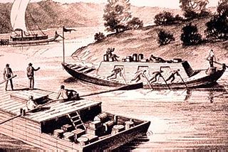
River pirates at Diamond Island preyed on the Mississippi River flatboats, keelboats, and rafts, as profitable targets of goods, attacking the crews and pioneers who were easily overwhelmed and killed. Keelboat and flatboat.jpg
River pirates at Diamond Island preyed on the Mississippi River flatboats, keelboats, and rafts, as profitable targets of goods, attacking the crews and pioneers who were easily overwhelmed and killed.
Part of a counterfeit coin mold similar to the type used by counterfeiters on Stack Island. The coin mold consisted of two metal halves that would be lined with clay to make an impression of a genuine coin, then molten lead would be poured into the mold, and the fake lead coin would be plated with a layer of silver. Legitimate coins were made by government mints that stamped them from silver or gold coin discs as most inferior counterfeit coins were usually molded. Counterfeiters Coin Mold Cropped.jpg
Part of a counterfeit coin mold similar to the type used by counterfeiters on Stack Island. The coin mold consisted of two metal halves that would be lined with clay to make an impression of a genuine coin, then molten lead would be poured into the mold, and the fake lead coin would be plated with a layer of silver. Legitimate coins were made by government mints that stamped them from silver or gold coin discs as most inferior counterfeit coins were usually molded.

Stack Island, also known as Crow's Nest and Island No. 94, is located in Issaquena County, Mississippi, in the Mississippi River, near Lake Providence, Louisiana and nearly 200 miles north of New Orleans.

Issaquena County, Mississippi U.S. county in Mississippi, United States

Issaquena County is a county located in the U.S. state of Mississippi. As of the 2010 census, the population was 1,406, making it the least populous county in the United States east of the Mississippi River. Its county seat is Mayersville. With a per-capita income of $18,598, Issaquena County is the poorest county in the United States.

Mississippi River largest river system in North America

The Mississippi River is the second-longest river and chief river of the second-largest drainage system on the North American continent, second only to the Hudson Bay drainage system. Its source is Lake Itasca in northern Minnesota and it flows generally south for 2,320 miles (3,730 km) to the Mississippi River Delta in the Gulf of Mexico. With its many tributaries, the Mississippi's watershed drains all or parts of 32 U.S. states and two Canadian provinces between the Rocky and Appalachian mountains. The main stem is entirely within the United States; the total drainage basin is 1,151,000 sq mi (2,980,000 km2), of which only about one percent is in Canada. The Mississippi ranks as the fourth-longest and fifteenth-largest river by discharge in the world. The river either borders or passes through the states of Minnesota, Wisconsin, Iowa, Illinois, Missouri, Kentucky, Tennessee, Arkansas, Mississippi, and Louisiana.

Lake Providence, Louisiana Town in Louisiana, United States

Lake Providence is a town in and the parish seat of East Carroll Parish in northeastern Louisiana. The population was 5,104 at the 2000 census but declined by 21.8 percent to 3,991 in 2010. The town's poverty rate is approximately 55 percent; the average median household income is $16,500, and the average age is 31.

History

Beginning, in the late 1790s, the island became associated with river pirates and counterfeiting. Outlaws associated with Stack Island include; Samuel Mason, Little Harpe, and father and son counterfeiters Philip and Peter Alston. [1]

River pirate

A river pirate is a pirate who operates along a river. The term has been used to describe many different kinds of pirate groups who carry out riverine attacks in Asia, Africa, Europe, North America, and South America. They are usually prosecuted under national, not international law.

Counterfeit money money that was created illegally

Counterfeit money is imitation currency produced without the legal sanction of the state or government usually in a deliberate attempt to imitate that currency and so as to deceive its recipient. Producing or using counterfeit money is a form of fraud or forgery. The business of counterfeiting money is almost as old as money itself: plated copies have been found of Lydian coins which are thought to be among the first Western coins. Before the introduction of paper money, the most prevalent method of counterfeiting involved mixing base metals with pure gold or silver. Another form of counterfeiting is the production of documents by legitimate printers in response to fraudulent instructions. During World War II, the Nazis forged British pounds and American dollars. Today some of the finest counterfeit banknotes are called Superdollars because of their high quality and likeness to the real US dollar. There has been significant counterfeiting of Euro banknotes and coins since the launch of the currency in 2002, but considerably less than for the US dollar.

Outlaw Person declared as outside the protection of the law

In historical legal systems, an outlaw is declared as outside the protection of the law. In pre-modern societies, the criminal is withdrawn all legal protection, so that anyone is legally empowered to persecute or kill them. Outlawry was thus one of the harshest penalties in the legal system. In early Germanic law, the death penalty is conspicuously absent, and outlawing is the most extreme punishment, presumably amounting to a death sentence in practice. The concept is known from Roman law, as the status of homo sacer, and persisted throughout the Middle Ages.

Island No. 94, or Stack Island, or, as it is sometimes called, "Crow's Nest." 170 miles above Natchez, was notorious for many years as a den for the rendezvous of horse thieves, counterfeiters, robbers, and murderers. It was a small island in the middle of "Nine Mile Reach." From thence they would sally forth, stop passing boats, murder the crew, or, if this seemed impracticable, would buy their horses, slaves, flour, whisky, etc., and pay for them.

Natchez, Mississippi Sole incorporated city in Mississippi, United States

Natchez is the county seat and only city of Adams County, Mississippi, United States. Natchez has a total population of 15,792. Located on the Mississippi River across from Vidalia in Concordia Parish, Louisiana, Natchez was a prominent city in the antebellum years, a center of cotton planters and Mississippi River trade.

Den (room) type of room in a house

A den is a small room in a house where people can pursue activities in private.

Meeting point place where people meet

A meeting point, meeting place, or assembly point is a geographically defined place where people meet. Such a meeting point is often a landmark which has become popular and is a convenient place for both tourists and citizens to meet. Examples of meeting points include public areas and facilities such as squares, statues, parks, amusement parks, railway stations, airports, etc. or officially designated and signed points in such public facilities. There is often a public sign designating an official meeting point in public facilities.

In 1809, the last major river pirate activity, on the Upper Mississippi River, came to an abrupt end, when a group of flatboatmen, meeting at the head of the "Nine Mile Reach," decided to make a raid on Stack Island and wipe out the river pirates. They attacked at night, a battle ensued, and two of the boatmen and several outlaws were killed. The attackers captured 19 other men, a 15-year-old boy and two women. The women and teenager were allowed to leave. The remaining outlaws are presumed to have been executed.

Flatboat rectangular flat-bottomed boat with square ends

A flatboat was a rectangular flat-bottomed boat with square ends used to transport freight and passengers on inland waterways in the United States. The flatboat could be any size, but essentially it was a large, sturdy tub with a hull.

Raid (military) military tactic or operational warfare mission which has a specific purpose

Raiding, also known as depredation, is a military tactic or operational warfare mission which has a specific purpose and is not normally intended to capture and hold a location but instead finish with the raiding force quickly retreating to a previous defended position prior to enemy forces being able to respond in a coordinated manner or formulate a counter-attack. A raiding group may consist of combatants specially trained in this tactic, such as commandos, or as a special mission assigned to any regular troops. Raids are often a standard tactic in irregular warfare, employed by warriors, guerrilla fighters or other irregular military forces. Some raids are large, for example the Sullivan Expedition.

The floods of 1811 and 1813, along with the 1811–12 New Madrid earthquakes, all but swept away the island leaving only a low sandbar. [2] From the 1820s-mid-1830s, John A. Murrell, the west Tennessee bandit, may have operated on the Mississippi River, not far from Stack Island.

1811–12 New Madrid earthquakes Seismic activity in North America during the nineteenth century

The 1811–12 New Madrid earthquakes were an intense intraplate earthquake series beginning with an initial earthquake of moment magnitude 7.5–7.9 on December 16, 1811, followed by a moment magnitude 7.4 aftershock on the same day. They remain the most powerful earthquakes to hit the contiguous United States east of the Rocky Mountains in recorded history. They, as well as the seismic zone of their occurrence, were named for the Mississippi River town of New Madrid, then part of the Louisiana Territory, now within the US state of Missouri.

Shoal A natural landform that rises from the bed of a body of water to near the surface and is covered by unconsolidated material

In oceanography, geomorphology, and earth sciences, a shoal is a natural submerged ridge, bank, or bar that consists of, or is covered by, sand or other unconsolidated material, and rises from the bed of a body of water to near the surface. Often it refers to those submerged ridges, banks, or bars that rise near enough to the surface of a body of water as to constitute a danger to navigation. Shoals are also known as sandbanks, sandbars, or gravelbars. Two or more shoals that are either separated by shared troughs or interconnected by past or present sedimentary and hydrographic processes are referred to as a shoal complex.

John Murrell (bandit) American criminal

John Andrews Murrell, the "Great Western Land Pirate" also known as John A. Murrell and commonly spelled as Murel and Murrel, was a bandit and criminal operating in the United States, along the Mississippi River, in the 19th century. Murrell had his first criminal conviction, for horse theft, as a teenager and was branded with an "HT", flogged, and sentenced to six years in prison. He was released in 1829. Murrell was convicted a second and final time, for the crime of slave stealing, in the Circuit Court of Madison County, Tennessee, and incarcerated in the Tennessee State Penitentiary in Nashville from 1834 to 1844.

Related Research Articles

Perry County, Mississippi U.S. county in Mississippi, United States

Perry County is a county located in the U.S. state of Mississippi. As of the 2010 census, the population was 12,250. The county seat is New Augusta. The county is named after the War of 1812 naval hero, Oliver Hazard Perry.

Cave-In-Rock, Illinois Village in Illinois, United States

Cave-In-Rock is a village in Hardin County, Illinois, United States. Its principal feature and tourist attraction is nearby Cave-In-Rock, on the banks of the Ohio River. In 1816, the earliest known permanent white settlers arrived and started building a town near the cave. The town was originally known as Rock and Cave, Illinois, with a post office under this name. On October 24, 1849, the town was officially renamed Cave-In-Rock. Cave-In-Rock was incorporated as a village in 1901. The population was 318 at the 2010 census.

Rosiclare, Illinois City in Illinois, United States

Rosiclare is a city in Hardin County, Illinois, along the Ohio River. The population was 1,160 at the 2010 census, down from 1,213 at the 2000 census.

Grand Tower, Illinois City in Illinois, United States

Grand Tower is a city in Jackson County, Illinois, United States. The population was 605 at the 2010 census. The town gets its name from Tower Rock, a landmark island in the Mississippi River.

Simmesport, Louisiana Town in Louisiana, United States

Simmesport is a town in Avoyelles Parish, Louisiana, United States. The population was 2,161 at the 2010 census. It is located near the juncture of the Red and Atchafalaya rivers with an outflow channel of the Mississippi River.

Extreme points of North America

This is a list of the extreme points of North America: the points that are highest and lowest, and farther north, south, east or west than any other location on the continent. Some of these points are debatable, given the varying definitions of North America.

This is a list of the extreme points of The Americas, the points that are farther north, south, east or west than any other location on the continent. The continent's southernmost point is often said to be Cape Horn, which is the southernmost point of the Chilean islands. The Americas cross 134° of longitude east to west and 124° of latitude north to south.

Partridge River (Crow Wing River tributary) river in the United States of America

The Partridge River and its tributary the Little Partridge River are small rivers in rural west-central Minnesota in the United States. The Partridge is a 32.6-mile-long (52.5 km) tributary of the Crow Wing River, via which it is part of the Mississippi River watershed.

James Ford (pirate) American pirate

James Ford, born James N. Ford, also known as James N. Ford, Sr. the "N" possibly for Neal, was an American civic leader and business owner in western Kentucky and southern Illinois, late 1790s to mid-1830s. Despite his clean public image as a "Pillar of the Community", Ford was secretly a river pirate and the leader of a gang that would come to be known as the "Ford's Ferry Gang". His gang was the river equivalent of highway robbers; they would hijack flatboats and Ford's "own river ferry" for tradable goods from local farms, coming down the Ohio River. Ford was an Illinois associate of Isaiah L. Potts and the Potts Hill Gang, highway robbers, of the infamous Potts Inn. James Ford also had an association with illegal slaver trader and kidnapper of free blacks, John Hart Crenshaw, and may have taken part in the Illinois version of the Reverse Underground Railroad. At one point, they used the "Cave-in-Rock" as their headquarters, on the Illinois side of the lower Ohio River, which is approximately 85 miles below Evansville, Indiana.

Harpe brothers American serial killers and outlaws

Micajah "Big" Harpe, born Joshua Harper, and Wiley "Little" Harpe, born William Harper, were murderers, highwaymen and river pirates who operated in Tennessee, Kentucky, Illinois and Mississippi in the late 18th century. They are often considered the earliest documented serial killers in the United States, reckoned from the colonial era forward.
Wolf Island, Missouri unincorporated community in Missouri

Wolf Island is an unincorporated community in eastern Mississippi County, Missouri, United States. It is located on Route 77, approximately nine miles east of East Prairie.

Border irregularities of the United States, particularly panhandles and highway incursions into other jurisdictions, are shown here. Often they are a result of borders which do not conform to geological features.

Banditti of the Prairie

The Banditti of the Prairie, also known as "The Banditti", "Prairie Pirates", "Prairie Bandits", and "Pirates of the Prairie", in the U.S. states of Illinois, Indiana, Ohio, and the Territory of Iowa, were a group of loose-knit outlaw gangs, during the early-mid-19th century. Though bands of roving criminals were common in many parts of Illinois, the counties of Lee, DeKalb, Ogle, and Winnebago were especially plagued by them. The new crime wave in the region of the frontier Middle West may have occurred following the crackdown on southern outlaws by the rising vigilante-regulator movement and the breakup of the criminal syndicate of John A. Murrell and his gang, the "Mystic Clan" in the Southern United States. In the year 1841, the escalating pattern of house burglary, horse and cattle theft, stagecoach and highway robbery, counterfeiting, and murder associated with the Banditti had come to a head in Ogle County. As the crimes continued, local citizens formed bands of vigilantes known as Regulators. A clash between the Banditti and the Regulators in Ogle County near Oregon, Illinois, resulted in the outlaws' demise and decreased Banditti activity and violent crime within the county.

Samuel Mason American judge

Samuel Ross Mason, also spelled Meason, was a Virginia militia captain, on the American western frontier, during the American Revolutionary War. After the war, he became the leader of the Mason Gang, a criminal gang of river pirates and highwaymen on the lower Ohio River and the Mississippi River in the late 18th and early 19th centuries. He was associated with outlaws around Red Banks, Cave-in-Rock, Stack Island, and the Natchez Trace.

Philip Alston was an 18th-century counterfeiter, both before and after the American Revolution. He operated in Virginia and the Carolinas before the war, and in Kentucky and Illinois afterward. He was associated with Cave-in-Rock and his son, outlaw Peter Alston, and counterfeiter John Duff. He was an early American settler in Natchez, as well as in the Cumberland and Red River valleys in Kentucky and Tennessee.
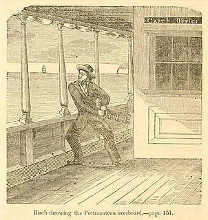
Robert H. Birch American criminal and prospector

Robert H. "Three-Fingered" Birch, born Robert Henry Birch, was a 19th-century American adventurer, criminal, soldier, lawman, postmaster, and prospector. He was a member of the infamous "Banditti of the Prairie" in his youth, whose involvement in the torture-murder of Colonel George Davenport in 1845 led to his turning state's evidence against his co-conspirators. Birch was also the discoverer of the Pinos Altos gold mine with Jacob Snively and James W. Hicks. During the American Civil War, he served in the American Southwest with the Confederate forces of the Arizona Rangers and 2nd Texas Cavalry.

The Pine River is a 56.9-mile-long (91.6 km) tributary of the Mississippi River in northern Minnesota, United States.

Peter Alston was an American counterfeiter, horse thief, highwayman, and river pirate of the late 18th and early 19th Centuries. He is believed to have been an associate of serial killer Little Harpe, who was notorious for the murder of outlaw Samuel Mason in 1803.

Battle of Tres Jacales

The Battle of Tres Jacales was an Old West gunfight that occurred on June 30, 1893. While out searching for a gang of rustlers, a group of American lawmen under the command of the Texas Ranger Frank Jones were attacked at the Mexican village of Tres Jacales. During the exchange of gunfire, Jones was mortally wounded and the remaining Americans were forced to retreat back into Texas.

References

  1. T. Marshall Smith. 1855. Legends of the War of Independence, and of the Earlier Settlements in the West. Louisville, Ky.: J. F. Brennan, Publisher. 342–344. Online at www.archive.org.
  2. E. W. Gould. 1889. Fifty Years on the Mississippi. 58–59. St. Louis: Nixon-Jones Printing Co. 58–59.
International Standard Book Number Unique numeric book identifier

The International Standard Book Number (ISBN) is a numeric commercial book identifier which is intended to be unique. Publishers purchase ISBNs from an affiliate of the International ISBN Agency.

Coordinates: 32°49′45″N91°08′01″W / 32.82917°N 91.13361°W / 32.82917; -91.13361