
Tissington is a village and former civil parish, now in the parish of Tissington and Lea Hall, in the Derbyshire Dales district of Derbyshire, England. In 2001 the parish had a population of 158. The population "Tissington and Lea Hall" at the 2011 census was 159. It is part of the estate of Tissington Hall, owned by the FitzHerbert family since 1465. It is a popular tourist attraction, particularly during its well dressing week. It also gives its name to the Tissington Trail, a 13-mile (21 km) walk and cycle path which passes nearby. The Limestone Way, another long-distance path and bridleway, passes through the village itself.

Meriden is a village and civil parish in the Metropolitan Borough of Solihull, West Midlands, England. Historically, it is part of Warwickshire and lies between the cities of Birmingham and Coventry. It is located close to the North Warwickshire district border within a green belt of the countryside known as the Meriden Gap and is in the ecclesiastical parish of the Diocese of Coventry.

Rothley is a village and civil parish within the Borough of Charnwood in Leicestershire, England. Situated around one-half mile west of the River Soar and five miles north of Leicester, it had a population of 3,612 inhabitants the 2001 census. The population measured at the 2011 census was 3,897.

The West Derby Hundred is one of the six subdivisions of the historic county of Lancashire, in northern England. Its name alludes to its judicial centre being the township of West Derby.

The history of Derbyshire can be traced back to human settlement since the last Ice Age, over 10,000 years ago. The county of Derbyshire in England dates back to the 11th century.

Rothley Temple, or more correctly Rothley Preceptory, was a preceptory in the village of Rothley, Leicestershire, England, associated with both the Knights Templar and the Knights Hospitaller.

Acklam is an area in the Borough of Middlesbrough, North Yorkshire, England. It is believed that the settlement is Anglo-Saxon in origin, the name is Old English for "place at the oak clearings" or "place of oaks".

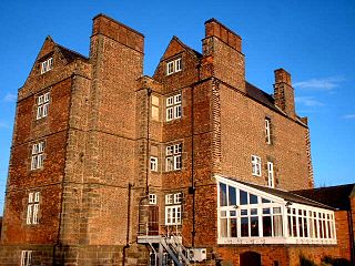
Dethick, Lea and Holloway is a civil parish, in the Amber Valley borough of the English county of Derbyshire. The population of the civil parish taken at the 2011 census was 1,027.
Weston-on-Trent is a village and civil parish in the South Derbyshire district of Derbyshire. The population of the civil parish at the 2011 census was 1,239. It is to the north of the River Trent and the Trent and Mersey Canal. Nearby places include Aston-on-Trent, Barrow upon Trent, Castle Donington and Swarkestone.

Knaptoft is a deserted medieval village and civil parish in the Harborough district of Leicestershire and lies approximately 9.7 miles (15.6 km) south of the city of Leicester, England. According to the University of Nottingham English Place-names project, the settlement name Knaptoft could mean "cnafa" for 'a boy, a young man, a servant, a menial, or a personal name' and 'toft', the plot of ground in which a dwelling stands. The population of the civil parish at the 2011 census was 47.

Arrow is a village in the Stratford-on-Avon district of Warwickshire, England. Together with the entirely rural hamlet of Weethley, it forms since 1 April 2004 the civil parish of Arrow with Weethley. The parish lies midway between Redditch and Evesham. From Alcester the River Arrow flows southwards to the river Avon, and to the west of the river the present road to Evesham joins that to Worcester at a busy junction where, near the Old Toll House, stands the hamlet of Arrow, a group of modernized black and white farm workers' cottages which have risen up the social scale to become homes for business people. Arrow with Weethley parish falls under the local government district and parliamentary constituency of Stratford-on-Avon, and the Church of England Diocese of Coventry. In 2001 the parish had a population of 208.

Topcliffe is a village and civil parish in the Hambleton district of North Yorkshire, England. The village is situated on the River Swale, on the A167 road and close to the A168. It is about 5 miles (8 km) south-west of Thirsk and 11 miles (18 km) south of the county town of Northallerton. It has a population of 1,489. An army barracks, with a Royal Air Force airfield enclosed within, is located to the north of the village.

Heath is a village in the North East Derbyshire district of the English county of Derbyshire.

Sutton Scarsdale Hall is a Grade I listed Georgian ruined stately home in Sutton Scarsdale, just outside Chesterfield, Derbyshire.
Newton Solney is a small village and civil parish in South Derbyshire, England, located about two miles (3 km) from the East Staffordshire border, near to Burton upon Trent. The population of the civil parish as of the 2011 census was 659. Its nearest neighbour is Repton, situated about two miles (3 km) to the northeast.

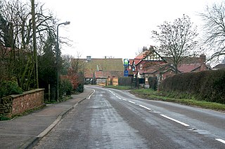
Sutton Scarsdale is a village in Derbyshire, England. It is in the North East Derbyshire district. It is very close to the M1 motorway. It is in the civil parish of Sutton cum Duckmanton.

Clifford is a small village in West Yorkshire, England. The population at the 2011 Census was 1,662. The village is 3 miles (4.8 km) south of Wetherby. Many of the older buildings are built of magnesian limestone.
Old Somerby is a village and civil parish in the South Kesteven district of Lincolnshire, England, 3 miles (5 km) south-east of Grantham. It lies on the B1176 road, with the village centre about 1 mile (1.6 km) east of its junction with the A52 and B6403, and adjacent to the East Coast Main Line.
Babington is the name of an Anglo-Irish and English gentry family. The Anglo-Irish branch of the family is still extant today.
The Hundreds of Derbyshire were the geographic divisions of the historic county of Derbyshire for administrative, military and judicial purposes. They were established in Derbyshire some time before the Norman conquest. In the Domesday Survey of 1086 AD the hundreds were called wapentakes. By 1273 the county was divided into 8 hundreds with some later combined, becoming 6 hundreds over the following centuries. The Local Government Act 1894 replaced hundreds with districts. Derbyshire is now divided into 8 administrative boroughs within the Derbyshire County Council area.

