
Samlesbury Hall is a historic house in Samlesbury, Lancashire, England, six miles (10 km) east of Preston. It was built in 1325 by Gilbert de Southworth, and was the primary home of the Southworth family until the early 17th century.

Ordsall Hall is a large former manor house in the historic parish of Ordsall, Lancashire, now part of the City of Salford, in Greater Manchester, England. It dates back more than 750 years, although the oldest surviving parts of the present hall were built in the 15th century. The most important period of Ordsall Hall's life was as the family seat of the Radclyffe family, who lived in the house for more than 300 years. The hall was the setting for William Harrison Ainsworth's 1842 novel Guy Fawkes, written around the plausible although unsubstantiated local story that the Gunpowder Plot of 1605 was planned in the house.

Kingston Lacy is a country house and estate near Wimborne Minster, Dorset, England. It was for many years the family seat of the Bankes family who lived nearby at Corfe Castle until its destruction in the English Civil War after its incumbent owners, Sir John Bankes and Dame Mary, had remained loyal to Charles I.

Adlington is a village and civil parish in the Borough of Chorley in Lancashire, England, near the West Pennine Moors. It is 3 miles south of Chorley. It became a separate parish in 1842 then grew into a township around the textile and coal mining industries until these closed in the 1960s. It had a population of 5,270 at the 2001 census, and risen to 6,010 at the 2011 census. The Leeds and Liverpool Canal runs through the village, where it holds White Bear Marina, the largest marina on the Canal.

Coppull is a village and civil parish in Lancashire, England. It is part of the Borough of Chorley, lies around 300 feet (91 m) above sea level. Its population is around 8,000, having been counted at 8,300 in the 2021Census. It is bounded by Whittle Brook, Clancutt Brook, the River Yarrow, Eller Brook, Hic-Bibi Brook and Stars Brook. Coppull is located between Chorley and Standish, Greater Manchester, to the east of the A49 road near Charnock Richard.

Standish is a town in the Metropolitan Borough of Wigan, Greater Manchester, England. Within the boundaries of the historic county of Lancashire, it is on the A49 road between Chorley and Wigan, near Junction 27 of the M6 motorway. The population of the town was 13,278 in the 2011 census.
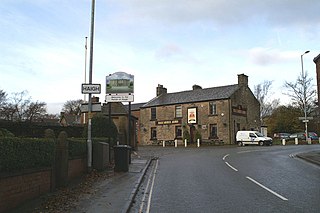
Haigh is a village and civil parish in the Metropolitan Borough of Wigan, Greater Manchester, England. Historically part of Lancashire, it is located next to the village of Aspull. The western boundary is the River Douglas, which separates the township from Wigan. To the north, a small brook running into the Douglas divides it from Blackrod. At the 2001 census it had a population of 594.

Astley is a village in the Metropolitan Borough of Wigan, Greater Manchester, England. Within the boundaries of the historic county of Lancashire, it is crossed by the Bridgewater Canal and the A580 East Lancashire Road. Continuous with Tyldesley, it is between Wigan and Manchester, both 8 miles (13 km) away. Astley Mosley Common ward had a population of 11,270 at the 2011 Census.

Redgrave is a village and civil parish in Suffolk, England, just south of the River Waveney that here forms the county boundary with Norfolk. The village is about 4+1⁄2 miles (7 km) west of the town of Diss. The 2011 Census recorded the parish population as 459.
The Selby family, of English gentry, originated in Selby, Yorkshire, but largely settled in Northumberland and County Durham. At various points through history, the family owned Biddlestone Hall and Twizell Castle in Northumberland in addition to the manor houses Ightham Mote in Kent and at Beal, Northumberland. The family had two baronetcies; the Selby and the Selby-Bigge but both are now extinct.

South Stoneham House is a Grade II* listed former manor house in Swaythling, Southampton; the former seat of the Barons Swaythling before the family moved to the nearby Townhill Park House. The building is owned by the University of Southampton, and was used as a hall of residence, part of the Wessex Lane Halls complex.

Tarbock is a village and former civil parish within the Metropolitan Borough of Knowsley, in Merseyside, England. It is situated to the south east of Huyton and to the east of Netherley. The village itself is 6 miles (9.7 km) from Liverpool city centre, 3.5 miles (5.6 km) from Widnes and 2 miles (3.2 km) from Prescot. The M62 motorway junction 6 is in the area and is more familiarly called Tarbock Island. At the 2001 Census, the population of Tarbock was 2,382. The parish council was abolished on 1 April 2014.

Lytes Cary is a manor house with associated chapel and gardens near Charlton Mackrell and Somerton in Somerset, England. The property, owned by the National Trust, has parts dating to the 14th century, with other sections dating to the 15th, 16th, 18th, and 20th centuries. "Yet all parts blend to perfection with one another and with the gentle sunny landscape that surrounds them," comments Nikolaus Pevsner. The House is listed as Grade I by English Heritage.
Rivington Hall is a Grade II* listed building in Rivington, Lancashire, England. It was the manor house for the Lords of the Manor of Rivington. The hall is of various builds as successor to a 15th-century timber-framed courtyard house that was built near to the present building of which no trace remains. It is a private residence.
Timperley Hall was a moated manor house in Timperley, Greater Manchester, England, first recorded in 1560, but almost certainly built to replace an earlier medieval structure. Very little remains of the 16th-century hall, which is not shown on the Tithe map of 1838. The date of the hall's demolition is unknown, but the size of the moat suggests that it was a "substantial" house. The present-day Timperley Hall was probably constructed during the late 18th century, close to the site of the older hall.

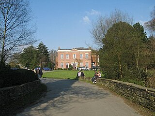
Haigh Hall is a historic country house in Haigh, Wigan, Greater Manchester, England. Built between 1827 and 1840 for James Lindsay, 7th Earl of Balcarres, it replaced an ancient manor house and was a Lindsay family home until 1947, when it was sold to Wigan Corporation. The hall is recorded in the National Heritage List for England as a designated Grade II* listed building and is owned by Wigan Council.

Duxbury Hall was a 19th-century country house in Duxbury Park estate in Duxbury Woods, Duxbury, Lancashire that has been demolished.

Moulsecoomb Place is a large 18th-century house on Lewes Road in the Moulsecoomb area of the English coastal city of Brighton and Hove. Originally a farmhouse based in an agricultural area in the parish of Patcham, north of Brighton, it was bought and extensively remodelled in 1790 for a long-established local family. It was their seat for over 100 years, but the Neoclassical-style mansion and its grounds were bought by the local council in the interwar period when Moulsecoomb was transformed into a major council estate. Subsequent uses have varied, and Moulsecoomb Place later became part of the University of Brighton's range of buildings. Student housing has been built to the rear; but much of the grounds, the house itself and a much older cottage and barn attached to the rear have been preserved. The house is a Grade II Listed building.
Adlington Hall was a Georgian country house, now demolished, in Adlington, Lancashire, England, between Wigan and Chorley.
The Standish family is an ancient English feudal manorial family and one of the oldest Anglo-Norman noble lineages. This Norman-roots family has been settled in Lancashire from the Conquest of England in 1066. The known history of the Standish family begins at the end of the twelfth century.


