Stanecastle

Last updated

Stanecastle
Stanecastle2007.JPG
Stanecastle in 2007
Stanecastle
General information
TypeTower
LocationStanecastle, Irvine
Coordinates grid reference NS3375939975
Construction startedca.1363
Renovatedca.1750
OwnerNorth Ayrshire Council

Stanecastle was a medieval barony and estate in North Ayrshire, Scotland, first mentioned in 1363 [1] and now part of the Irvine New Town project. Its nearest neighbours are Bourtreehill and Girdle Toll.

Contents

Roman origins?

The early history of Stanecastle is obscure but it was once believed that the "stane" (stone, Norse: steinn) prefix referred to older Roman structures. [1] However, it is now known that stone building in Scotland and Ayrshire was not restricted to the Roman and Norman periods, and need not suggest any such Roman origins.

Medieval life

The ancient name of the barony was the "Barony of Stane (Stone)". A ley tunnel is said to run from Seagate Castle in Irvine to Stane Castle. [2]

Saint Bridget

William Fraunces de le Stane held lands which included a chapel dedicated to Saint Bridget. The chapel stood on the muir near to Stane on the right bank of the Annick Water. [3]

At the core of the medieval estate may have been an older medieval nunnery or convent [4] and evidence has been discovered (and long lost under a turnpike road) of a small medieval chapel, probably dedicated to St. Bridget and, as was the norm, had its own graveyard (also long buried underneath the road). In the 17th century the twenty shilling lands of old extent called Brydskirk are recorded, but with no mention of a chapel. [5]

Stane castle

The original castle was built circa 1417 by the Francis family, who also held land at Sprouston near Kelso. The barony passed by marriage to the Montgomerys of Greenfield. [6]

Coat of arms of the Montgomeries at Eglinton. The 'rings' represent the Eglinton family. The quarters are misplaced. Eglinton Montgomerie coat of Arms.JPG
Coat of arms of the Montgomeries at Eglinton. The 'rings' represent the Eglinton family. The quarters are misplaced.
The Stanecastle armorial panel Stanecastle and armorial panel.JPG
The Stanecastle armorial panel

In the middle-ages, Stanecastle gave way to the ever-expanding Eglinton Empire and William Francis of Stane passed his estate on to the Earls of Eglinton in the 15th century. Campbell states that the present castle was built in 1520 by Montgomerie of Greenfield, a cadet branch. [7]

In 1750 Alexander, 10th Earl of Eglinton, repaired the castle, converting it into a folly. The four open and four closed pointed windows were constructed for appearance only at this time and on the west side an armorial panel stone with the Earl of Eglinton's arms was put in place. Through some mistake this panel was said to have been placed upside down; [8] [9] however, the shield is actually the right way up. The apparent fault is that the signet rings and fleur de lis inside are upside down. Another error occurs on a similar-sized armorial panel now preserved in the quadrangle of Eglinton Country Park in which the symbols are in the wrong quarters. An original feature is a spiral stair in the north-east corner. [10]

The Toll Road Act of 1774 gives details of The Road from the Cockpitt near Stone-Castle by Armsheugh, .... [11] Showing that, not unusually, a Cock Pit existed here at one time.

A Ley tunnel is said to run from Stanecastle to Eglinton Castle and Seagate in Irvine. Another tunnel is said to run from Stanecastle to Dundonald. A subterranean passage was found by workmen at Stanecastle in the 19th century. [12]

Knadgerhill was only acquired by the Earls of Eglinton in 1851 when they excambied part of the lands of Bogside Flats for them. This allowed the construction of the new entrance to the policies at Stanecastle via Long Drive. [13]

Robert Burns

During 1781–1782 Robert Burns lived in Irvine and it is recorded that his favourite walk was through the Eglinton Woods. References to his passing Saint Bride's Well suggest that he may have passed through Stanecastle on his return journey, having walked along the old Toll Road, over the Drukken Steps at the Red burn and back to Irvine via Millburn, Sourlie, Girdle Gate and Stanecastle.

19th century

Stanecastle has been the subject of a few sentences from John Galt (born 1779), a native of Irvine, in his Ringan Gilhaize (1823) novel.

Stanecastle today

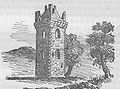
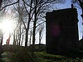
Visible today is the superb keep of the original estate, into whose wall is set an inscribed stone. This keep was altered with the addition of eight mock-Gothic arched windows in the 18th century, and has a modern roof with chimney and windows. Irvine Development Corporation stabilised and carried out repairs on the structure. The Montgomery Society of Scotland had attempted to purchase it as a clan headquarters and museum, but the plans came to nothing. [14]

Opposite the keep is the Stanecastle gate, a considerably younger structure but inkeeping with the overall design of the area. In the 20th century, this gateway, or rather its orientation, was altered. It once marked the southern entrance to the huge Eglinton Castle estate, now the Eglinton Country Park.

The remaining section of the estate has been fenced off and protected. For many years, the modern gate was padlocked and this has given way to a more open policy.

A record exists for the rare Rusty-Back Fern growing on the walls of the castle in the early 1900s. A search in 2002 did not locate the fern.

See also

Related Research Articles

<span class="mw-page-title-main">Irvine, North Ayrshire</span> Administrative centre, new town and former royal burgh in Scotland

Irvine is a town on the coast of the Firth of Clyde in North Ayrshire, Scotland. The 2011 Census recorded the town's population at 33,698 inhabitants, making it the largest settlement in North Ayrshire, and 22nd largest settlement in Scotland.

<span class="mw-page-title-main">Dundonald, South Ayrshire</span> Human settlement in Scotland

Dundonald is a village in South Ayrshire, Scotland.

<span class="mw-page-title-main">Eglinton Castle</span> Gothic castellated mansion in Kilwinning, Scotland

Eglinton Castle was a large Gothic castellated mansion in Kilwinning, North Ayrshire, Scotland.

<span class="mw-page-title-main">Auchenharvie Castle</span>

Auchenharvie Castle is a ruined castle near Torranyard on the A 736 Glasgow to Irvine road. Burnhouse lies to the north and Irvine to the south. It lies in North Ayrshire, Scotland.

Knockentiber is a village in East Ayrshire, Parish of Kilmaurs, Scotland. Knockentiber is two miles west-northwest of Kilmarnock and 12 mile northeast of Crosshouse. Latitude:55.6193°N Longitude:4.5455°W and grid reference NS397392. The population was 359 in 1991, however the population is much higher following the construction of several housing estates (2007). In the 18th and 19th and mid 20th centuries the locality was a highly industrialised coal mining district. The settlement is on the Carmel Burn, which runs into the River Irvine, around one mile to the south.

<span class="mw-page-title-main">Barony and Castle of Giffen</span> Barony in the former District of Cunninghame, now North Ayrshire

The Barony of Giffen and its associated 15th-century castle were in the parish of Beith in the former District of Cunninghame, now North Ayrshire. The site may be spelled Giffen or Giffin and lay within the Lordship of Giffin, which included the Baronies of Giffen, Trearne, Hessilhead, Broadstone, Roughwood and Ramshead; valued at £3,788 9s 10d. The Barony of Giffen comprised a number of properties, including Greenhills, Thirdpart, Drumbuie, Nettlehirst and Balgray, covering about half of the parish of Beith. Giffen was a hundred merk land, separated from the Barony of Beith, a forty-pound land, by the Powgree Burn which rises on Cuff hill. The Lugton Water or the Bungle Burn running through Burnhouse may have been the Giffen barony boundary with that of the adjacent barony and lands of Aiket castle.

<span class="mw-page-title-main">Eglinton Country Park</span>

Eglinton Country Park is located on the grounds of the old Eglinton Castle estate in Kilwinning, North Ayrshire, Scotland. Eglinton Park is situated in the parish of Kilwinning, part of the former district of Cunninghame, and covers an area of 400 ha ([98 acres ] of which are woodland. The central iconic feature of the country park is the ruined Eglinton Castle, once home to the Eglinton family and later the Montgomeries, Earls of Eglinton and chiefs of the Clan Montgomery. Eglinton Country Park is managed and maintained by North Ayrshire Council and its Ranger Service.

Riccarton is a village and parish in East Ayrshire, Scotland. It lies across the River Irvine from Kilmarnock, this river forming the boundary between Riccarton and Kilmarnock parishes, and also between the historical districts of Kyle and Cunningham. The name is a corruption of 'Richard's town', traditionally said to refer to Richard Wallace, the uncle of Sir William Wallace. The parish also contains the village of Hurlford.

<span class="mw-page-title-main">Clonbeith Castle</span>

The Castle of Clonbeith is in the old feudal Baillerie of Cunninghame, near Auchentiber, on a sideroad off the B778, in what is now North Ayrshire, Scotland.

<span class="mw-page-title-main">Busbie Castle</span>

Busbie Castle was situated in what is now known as Knockentiber, a village in East Ayrshire, Parish of Kilmaurs, Scotland. Knockentiber is 2 miles (3.2 km) WNW of Kilmarnock and 1/2 mile NE of Crosshouse. The castle overlooked the Carmel Glen and its Burn, which runs into the River Irvine, a mile or so to the south, after passing through the old Busbie Mill.

<span class="mw-page-title-main">Robert Burns and the Eglinton Estate</span>

During the years 1781–1782, at the age of 23, Robert Burns (1759–1796) lived in Irvine, North Ayrshire for a period of around 9 months, whilst learning the craft of flax-dressing from Alexander Peacock, who may have been his mother's half-brother, working at the heckling shop in the Glasgow Vennel. Dr John Cumming of Milgarholm, a provost of Irvine, claimed that he had invited Burns to come to Irvine to learn flax dressing. During this time he made a number of acquaintances, befriended several locals and took regular walks into the Eglinton Woods via the old Irvine to Kilwinning toll road and the Drukken or Drucken (Drunken) Steps. Steps over the Red Burn and back via the site of Saint Brides or Bryde's Well at Stanecastle. Burns had several other connections with the Eglinton Estate and other branches of the Montgomerie family. He probably left in March 1782.

<span class="mw-page-title-main">Drukken Steps</span>

The Drukken, Drucken Steps or Drunken Steps were stepping stones across the Red Burn in Irvine, North Ayrshire, Scotland and are associated with Scotland's national poet, Robert Burns. Drukken is used on the commemorative cairn plaque, but Druken or Drucken may also be used.

<span class="mw-page-title-main">Crosbie Castle and the Fullarton estate</span>

Crosbie Castle and the Fullarton estate lie near Troon in South Ayrshire. The site was the home of the Fullarton family for several centuries. The lands were part of the feudal Barony of Corsbie Fullartoune (sic). The Crosbie Castle ruins were eventually used as an ice house after the new Fullarton House mansion was built. The mansion house was later demolished and the area set aside as a public park and golf course.

<span class="mw-page-title-main">Skelmorlie Castle</span>

Skelmorlie Castle stands on the eastern shore of the Firth of Clyde, Scotland, at the north-western corner of the county of Ayrshire. The structure dates from 1502, and was formerly the seat and stronghold of the Montgomery Clan. The modern village of Skelmorlie lies to the north of the castle.

<span class="mw-page-title-main">Castle and Barony of Robertland</span>

The Castle and Barony of Robertland is located near Stewarton, off the B769 road, in the old district of Cunninghame, Parish of Stewarton, and now part of East Ayrshire, Scotland.

<span class="mw-page-title-main">Seagate Castle</span>

Seagate Castle is a castle and fortified town house in North Ayrshire, in the town of Irvine, close to the River Irvine, Scotland. The castle was formerly a stronghold, a town house, and later a dower house of the Montgomery Clan. The castle overlooks the oldest street in Irvine, which was once the main route between the town and the old harbour at Seagatefoot, which by 1606, was useless and abandoned due to silting. The remains of the castle are protected as a scheduled ancient monument.

<span class="mw-page-title-main">Trindlemoss Loch</span> Drained freshwater loch in North Ayrshire, Scotland

Trindlemoss Loch, Scott's / Scot's Loch or the Loch of Irvine was situated in a low-lying area running from Ravenspark to near Stanecastle and down to Lockwards, now represented only by the playing fields off Bank Street in the Parish of Irvine, North Ayrshire, Scotland. The loch was natural, sitting in a hollow created by glaciation. The loch waters were progressively drained and in 1691 this was finally achieved.

<span class="mw-page-title-main">Shewalton House and estate</span> Human settlement in Scotland

Shewalton House and estate were composed of the 'Lands of Shewalton' and the laird's dwelling, originally a tower castle and later a mansion house on the River Irvine in the Shewalton area, two miles from Irvine and west of Drybridge village, East Ayrshire, Dundonald Parish, Scotland. In 1883 the Boyle's estate of Shewalton was 2,358 acres in extent in Ayrshire and was worth at that time £2,708 a year.

Montgomerieston, sometimes known as Montgomeryston or Ayr Fort, was a small burgh of regality and barony of only 16 acres or 6.5 hectares located within the walls of the old Ayr Citadel, also known as Cromwell's Fort or Oliver's Fort, situated in the town of Ayr, South Ayrshire, Scotland. Montgomerieston was named for the Montgomerie family, Earls of Eglinton.

<span class="mw-page-title-main">Lawthorn</span> Human settlement in Scotland

Lawthorn is a hamlet near Perceton in Strathannick, Irvine, North Ayrshire, Scotland. The settlement lies on the old Irvine to Stewarton toll road.

References

  1. 1 2 Strawhorn, John (1985). The History of Irvine. Pub. John Donald. ISBN   0-85976-140-1. P. 3.
  2. Strawhorn, John (1994). The History of Irvine. Edinburgh : John Donald. ISBN   0-85976-140-1. p. 35
  3. McJannet, Arnold F. (1938). The Royal Burgh of Irvine. Glasgow : Civil Press. p. 11 and p. 67.
  4. "RCAHMS Canmore site". Archived from the original on 23 December 2012. Retrieved 15 September 2007.
  5. Strawhorn, John (1985). The History of Irvine. Pub. John Donald. ISBN   0-85976-140-1. P. 30.
  6. Coventry, Martin (2010). Castles of the Clans. Musselburgh : Goblinshead. ISBN   1-899874-36-4. p. 210
  7. Campbell, Thorbjørn (2003). Ayrshire. A Historical Guide. Edinburgh : Birlinn. ISBN   1-84158-267-0. p. 196
  8. MacGibbon, David and Ross, Thomas (1990), The Castellated and Domestic Architecture of Scotland from the 12th to the 18th century. Vol. V. Edinburgh : James Thin. ISBN   0-901824-18-6. P. 351 - 352.
  9. Campbell, Thorbjørn (2003). Ayrshire. A Historical Guide. Edinburgh : Birlinn. ISBN   1-84158-267-0. P. 196
  10. Salter, Page 60
  11. McClure, David (1994). Tolls and Tacksmen. Ayr Arch & Nat Hist Soc. Ayrshire Monograph No.13. P. 53
  12. Irvine Times, 04-02-2009. p. 18.
  13. Strawhorn, page 125.
  14. Eglinton Archive, Eglinton Country Park

55°37′30″N4°38′30″W / 55.6249°N 4.6418°W / 55.6249; -4.6418