Stanford is a deserted village and civil parish in the Englishcounty of Norfolk. It is situated 7+1⁄2 miles (12km) north of the town of Thetford and 25 miles (40km) southwest of the city of Norwich.[1]
The name of the village derives from Old English and means "stony ford".[2]
The village became deserted when it was taken over by the British Army during the Second World War as part of the Stanford Battle Area, an infantry training area that is still in use. The village and most of the parish are within a restricted area and access is not allowed without special permission from the Army.[3]
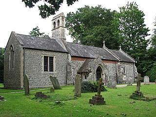
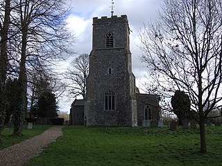
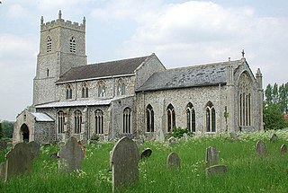
The parish church of All Saints, like the other surviving churches within the training area, is fitted with blast-proof sheeting to protect the structure, and wire fencing surrounds the church and churchyard to protect from military manoeuvres.[citation needed]
The civil parish has an area of 5.26sqmi (13.6km2) and in the 2001 census had a population of eight in four households. For the purposes of local government, the parish falls within the district of Breckland.[4] At the 2011 census the population remained less than 100 and was included in the civil parish of Croxton.[citation needed]
Notes
↑ Ordnance Survey (1999). OS Explorer Map 229 - Thetford in the Brecks. ISBN0-319-21861-9.
West Dereham is a village and civil parish in the English county of Norfolk. It covers an area of 13.51 km2 (5.22 sq mi) and had a population of 440 in 176 households as of the 2001 census, the population increasing to 450 at the 2011 Census. For the purposes of local government, it falls within the district of King's Lynn and West Norfolk.
Northwold is a village and civil parish in the English county of Norfolk. It covers an area of 19.72 km2 (7.61 sq mi) and had a population of 1,070 in 448 households at the 2001 census, increasing to 1,085 at the 2011 Census. For the purposes of local government, it falls within the district of King's Lynn and West Norfolk. The civil parish also includes the hamlets of Whittington and Little London.
Quidenham is a small rural village and civil parish in the English county of Norfolk. It covers an area of 22.51 km2 (8.69 sq mi) and had a population of 576 in 183 households at the 2001 census, falling to a population of 560 living in 189 households at the 2011 Census. For the purposes of local government, it falls within the district of Breckland.
Saham Toney is a village and a civil parish in the English county of Norfolk. The village is 14.5 miles (23.3 km) north of Thetford, 27.3 miles (43.9 km) west of Norwich and 101 miles (163 km) north-east of London. The village lies 13.1 miles (21.1 km) west of the town of Attleborough. The nearest railway station is at Attleborough for the Breckland Line which runs between Cambridge and Norwich. The nearest airport is Norwich International Airport. The civil parish has an area of 16.51 km2 (6.37 sq mi) and in 2001 had a population of 1,565 in 680 households, reducing to 1,507 in 679 households at the 2011 Census. For the purposes of local government, the parish falls within the district of Breckland.
Brundall is a village and civil parish in the English county of Norfolk. It is located on the north bank of the River Yare opposite Surlingham Broad and about 7 miles (11 km) east of the city of Norwich.
Keswick is a village and former civil parish, now in the parish of Keswick and Intwood, in the South Norfolk district, in the county of Norfolk, England. It is situated some 3 miles (4.8 km) to the south of the city of Norwich. It should not be mistaken for the coastal settlement of Keswick, near Bacton, which is also in Norfolk.
Wramplingham is a village and civil parish in the English county of Norfolk. It is situated on the River Tiffey some 4 miles (6.4 km) north of Wymondham and 7 miles (11 km) west of Norwich. The civil parish has an area of 3.47 square kilometres and in 2001 had a population of 110 in 44 households, increasing to a population of 115 in 51 households at the 2011 Census. For the purposes of local government, the parish falls within the district of South Norfolk.
Wretham is a civil parish in the Breckland district of Norfolk, England. The parish includes the village of East Wretham, which is about 6 miles (10 km) northeast of Thetford and 25 miles (40 km) southwest of Norwich. It also includes the villages of Illington and Stonebridge. The parish has an area of 32.25 km2 (12.45 sq mi). The 2011 Census recorded a parish population of 374 people in 141 households.
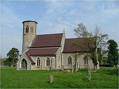
Sturston is a deserted village and civil parish in the English county of Norfolk. It is situated some 7+1⁄2 miles (12 km) north of the town of Thetford and 25 miles south-west of the city of Norwich.
Winfarthing is a village and civil parish in the English county of Norfolk. It is located 6 km north of the town of Diss, 20 km east of the town of Thetford, and 30 km south of the city of Norwich.
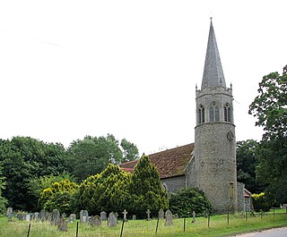
Tottington is a deserted village and civil parish in the English county of Norfolk. It is situated some 6.2 miles (10.0 km) north of the town of Thetford and 25 miles (40 km) south-west of the city of Norwich. Any population at the 2011 Census was included in the civil parish of Thompson.
Snetterton is a village and civil parish in Norfolk, England. The village is about 9 miles (14 km) east-northeast of Thetford and 19 miles (31 km) southwest of Norwich. The civil parish has an area of 8.94 km2 (3.45 sq mi). The 2011 Census recorded a parish population of 201 people living in 74 households.
Thornham is a village and civil parish in the English county of Norfolk. It is situated on the north Norfolk coast some 7 kilometres (4.3 mi) north-east of the seaside resort of Hunstanton, 30 km (19 mi) north of the town of King's Lynn and 70 km (43 mi) north-west of the city of Norwich.
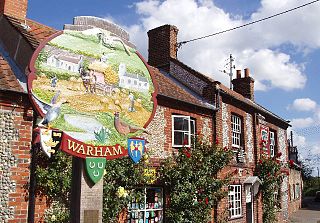
Warham is a village and civil parish in the English county of Norfolk. It is situated about 5 km (3.1 mi) inland from the north Norfolk coast, 5 km (3.1 mi) south-east of the town of Wells-next-the-Sea and 50 km (31 mi) north-west of the city of Norwich.
Pudding Norton is a village and civil parish in the English county of Norfolk. It covers an area of 2.30 sq mi (6.0 km2) and had a population of 267 in 126 households at the 2001 census, falling to 252 at the 2011 Census. For the purposes of local government, it falls within the district of North Norfolk.
Hemblington is a civil parish in the English county of Norfolk, about 8 miles (13 km) east of Norwich. It covers an area of 3.03 km2 (1.17 sq mi) and had a population of 316 in 134 households at the 2001 census, increasing to a population of 332 in 146 households at the 2011 Census. For the purposes of local government, it falls within the district of Broadland. As well as the village of Hemblington the parish includes the hamlet of Pedham some 1+1⁄2 miles (2 km) to the northwest.
Foulden is a village and civil parish in the English county of Norfolk. The village is located 12 miles (19 km) north west of Thetford and 29 miles (47 km) west of Norwich, along the River Wissey.
Skeyton is a small village and civil parish in the English county of Norfolk. The village and parish of Skeyton had in the 2001 census a population of 200, increasing slightly to 207 at the 2011 census. For the purposes of local government, the parish falls within the district of North Norfolk. Skeyton lies 4 miles (6.4 km) east of the market town of Aylsham, 13.5 miles (21.7 km) south of Cromer, 13.4 miles (21.6 km) north of Norwich and 129 miles (208 km) north-east of London. The nearest railway station is at North Walsham for the Bittern Line which runs between Sheringham, Cromer and Norwich. The nearest airport is Norwich International Airport.
Great Cressingham is a Norfolk village which lies about 5 miles (8 km) of Watton, 6 miles (10 km) south of Swaffham and only 1.5 miles (2.4 km) off the A1065 arterial road just north of Hilborough. It is 2.5 miles (4 km) north west by road from Little Cressingham. In 2007 it had an estimated population of 235, in an area of 9.84 km2 (3.80 sq mi), including Little Cressingham and increasing to 421 at the 2011 Census.
Lynford is a village and civil parish in the Breckland District of Norfolk. The parish covers an area of 24.72 km2 (9.54 sq mi), and the 2001 Census recorded a population of 157 in 81 households. Lynford lies 4 miles (6.4 km) north east of Brandon and between Mundford, 2 miles (3.2 km) to the north west, and Thetford, 6.5 miles (10.5 km) to the south east, on the A134. It lies deep within Breckland forestry land between the Stanford Battle Area and Thetford Forest.
This page is based on this Wikipedia article Text is available under the CC BY-SA 4.0 license; additional terms may apply. Images, videos and audio are available under their respective licenses.