Stanton Long

Last updated

Stanton Long
St. Michael and All Angels, Stanton Long - geograph.org.uk - 121035.jpg
St. Michael and All Angels Church, Stanton Long
Shropshire UK location map.svg
Red pog.svg
Stanton Long
Location within Shropshire
Population310 (2011) [1]
OS grid reference SO571906
Civil parish
  • Stanton Long
Unitary authority
Ceremonial county
Region
Country England
Sovereign state United Kingdom
Post town Much Wenlock
Postcode district TF13
Dialling code 01746
Police West Mercia
Fire Shropshire
Ambulance West Midlands
UK Parliament
List of places
UK
England
Shropshire
52°30′43″N2°37′52″W / 52.512°N 2.631°W / 52.512; -2.631

Stanton Long is a small village and civil parish situated in the district of Corve Dale, Shropshire, England. It is one of three parishes in the local area, including Easthope and Shipton. In the National Gazetteer of Great Britain and Ireland 1868, it was described as:

Contents

"a parish in the hundred of Munslow, county Salop, 7½ miles S.W. of Much Wenlock, its post town, and 10 W. of Bridgnorth. The village, which is small, is situated on the river Corve, and on the road from Skipton to Holdgate. The inhabitants are agricultural. The parish includes the townships of Brocton and Patton." [2]

History

Total Population of Stanton Long Civil Parish, Shropshire, as reported by the Census of Population from 1801 to 1961. Stanton Long population time series 1801-1961.jpg
Total Population of Stanton Long Civil Parish, Shropshire, as reported by the Census of Population from 1801 to 1961.

The name Stanton can be interpreted in Anglo-Saxon as a 'Stone farm/settlement', due to the topographic features it resides on. The 'Long' element of the place name refers to the parish's unusually elongated shape. [3] Although the parish boundaries have varied slightly over time, it still preserves its elongated shape to this day. It is restricted by the two nearby parishes of Shipton and Easthope, which causes it to become thin in the middle of the boundary and wider near the north and south borders. The actual settlement of Stanton Long is located in the south and other townships such as Brockton and Patton are in the north. [4] Historically the placename was also written as "Long Stanton".

Stanton Long's history can be traced back to the 13th century according to the 1086 Domesday Book entry, where it was under ownership of Roger de Lacy from Earl Roger de Montgomerie. This entry was then categorised under the parish of Stantune which became separated into two estates; Stanton Long and Holdgate in the 12th century. [5] Back then it was under the hundred of Patton and had a total number of just three households consisting of 1 smallholder and 2 slaves. This was considered a very small settlement compared to other Domesday settlements. [6]

In the 17th and 18th centuries the village was known as 'Dirty Stanton' due to the area's abundance in clay soil, making the roads muddy. [7]

The first census data recorded for the civil parish can be found back in 1801 where it had a total population of 206. This figure grew at a constant rate for the next five decades until 1841 where it reached its peak of 327 inhabitants. Since this period, the population has been slowly declining until the recent census in 2011, where it has been its lowest on record. [8]

There are a number of listed buildings in the parish, all of which were put under the Heritage Protection Reform from the 1970s onwards. Some of these buildings include the Malt House, Lower Farm House and St. Michael and All Angels Church. [9]

Present day

Employment of population in Stanton Long as reported by the 2011 UK Census data Employment status in Stanton Long as of the 2011 UK Census.jpg
Employment of population in Stanton Long as reported by the 2011 UK Census data
Employment of population in Stanton Long as reported by the 1881 UK Census data Stanton Long Employment- 1881.jpg
Employment of population in Stanton Long as reported by the 1881 UK Census data

In 2011 the UK Census showed that Stanton Long had a total population of 310. [10] This census data also shows that the Wholesale and Retail trade is the most popular industry in the parish, with other industries such as Human Health and Social Work Activities and Agriculture, Forestry and fishing also receiving similar figures. [11] Although previously, the 1881 census data showed that the Agriculture industry was by far the dominant trade, with over 50 males then involved in that area of work, the industry of the parish has almost certainly transformed into the present day. [12]

In terms of transport services, the nearest bus route that passes through the parish can be accessed via Brockton. Although, the nearest stop to the main village of Stanton Long would be at the nearby village of Shipton. There are only two services passing through this route with limited activity from Monday to Friday. [13]

The local housing is predominantly detached, whole housing or bungalows, [14] which are valued on average at around £240,408 (based on the local outward code). [15]

Geology

The parish is partially located along one of Britain's most important geological sites named Wenlock Edge. The land between Craven Arms and Much Wenlock sits on top of a Silurian limestone ridge, rich in fossil fauna. Fossil species such as corals, brachiopods, trilobites and ostracods exist along this 30 kilometre stretch of limestone, which is identified as a Site of Special Scientific Interest. [16] The edge contains limestone quarries and limekilns as well as ancient woodland making it a popular walking destination. [17]

Brockton

Brockton is a township within the parish and a settlement of similar size to that of Stanton Long. The hamlet is divided by the parish boundary between Stanton Long and Shipton, with the school and pub in Stanton Long and the farm in Shipton. It lies approximately 3.5 kilometres from the centre of Stanton Long and contains the local public house called The Feathers at Brockton [18] and the local primary school for those in the nearby catchment area. Brockton Church of England Primary School was a replacement school built in 1971 to take the place of an old Victorian establishment that once stood there. It is situated to the west of the township, parallel to a small stream which requires crossing a bridge to get into the grounds. [19] The 2011 inspection report from Ofsted shows that the establishment achieved an overall score of 2 (good) and was praised for its knowledgeable staff. [20]

Places of interest

River Corve - downstream of bridge at Brockton - geograph.org.uk - 1282654 River Corve - downstream of bridge at Brockton - geograph.org.uk - 1282654.jpg
River Corve – downstream of bridge at Brockton – geograph.org.uk – 1282654

St. Michael and All Angels is located in the heart of Stanton Long village and is the second parish church to have served the community. Due to the movement of local residents going southwards, Stanton Long provided a more suitable location than Patton thus justifying the construction of a new parish church. One of its defining features is the entrance door with iron scrollwork. Its construction dates back to the 13th century. [21] Although major repairs were carried out in 1842 and 1869–70, features such as the Bell-cote, bells, Vestry, porch and windows require restoration or repair. [22] The church contains a parish war memorial in form of marble tablet to local men who died serving in both World Wars, and a decorated metal plaque to Wallace Jones (killed in action in Palestine in the First War). [23] The churchyard contains the war graves of a Royal Warwickshire Regiment soldier of World War I and a KSLI soldier of World War II. [24]

The River Corve is a tributary within the Teme drainage basin that reaches typical highs of 2.5 meters and lows of 0.77 meters. [25] The river runs southwards to the east of Brockton and works its way past the nearby village of Shipton to the west of Stanton Long. It then joins the River Teme at the town of Ludlow approximately 8.5 kilometres to the south. [26]

See also

Related Research Articles

<span class="mw-page-title-main">Ludlow</span> Town in Shropshire, England

Ludlow is a market town and civil parish in Shropshire, England. The town is significant in the history of the Welsh Marches and in relation to Wales. It is located 28 miles (45 km) south of Shrewsbury and 23 miles (37 km) north of Hereford, on the A49 road which bypasses the town. The town is near the confluence of the rivers Corve and Teme.

<span class="mw-page-title-main">Church Stretton</span> Market town in Shropshire, England

Church Stretton is a market town and civil parish in Shropshire, England, 13 miles (21 km) south of Shrewsbury and 15 miles (24 km) north of Ludlow. The population in 2011 was 4,671.

<span class="mw-page-title-main">Much Wenlock</span> Town and parish in England

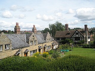
Much Wenlock is a market town and parish in Shropshire, England, situated on the A458 road between Shrewsbury and Bridgnorth. Nearby, to the northeast, is the Ironbridge Gorge and Telford. The civil parish includes the villages of Homer, Wyke, Atterley, Stretton Westwood and Bourton. The population of the civil parish, according to the 2001 census, was 2,605, increasing to 2,877 at the 2011 Census.

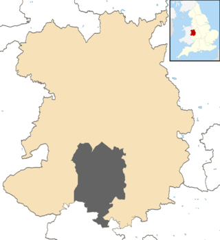
Shropshire was established during the division of Saxon Mercia into shires in the 10th century. It is first mentioned in 1006. After the Norman Conquest it experienced significant development, following the granting of the principal estates of the county to eminent Normans, such as Roger De Montgomery and his son Robert de Bellême.

<span class="mw-page-title-main">Abdon, Shropshire</span> Human settlement in England

Abdon is an upland village and former civil parish, now in the parish of Abdon and Heath, in Shropshire, England. In 2011 the parish had a population of 199. It is in the Clee Hills.

<span class="mw-page-title-main">Beckbury</span> Village and civil parish in Shropshire, England

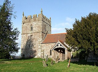
Beckbury is a village and civil parish in Shropshire, England. Beckbury had a population of 327 according to the 2001 census, increasing to 340 at the 2011 Census, The village is 8 miles (13 km) south-east of Telford and is close to the Staffordshire border. The small rural parish of Beckbury lies on the Shropshire–Staffordshire border 3.7 miles (6 km) south of Shifnal. It has a pub – the Smokey Cow, a Church of England school, a village hall, and a parish church dedicated to St Milburga.

<span class="mw-page-title-main">Bromfield, Shropshire</span> Human settlement in England

Bromfield is a village and civil parish in Shropshire, England.

<span class="mw-page-title-main">Ludford, Shropshire</span> Village in Shropshire, England

Ludford is a small village and civil parish in south Shropshire, England. The parish is situated adjacent to the market town of Ludlow and was, until 1895, partly in Herefordshire.

<span class="mw-page-title-main">Stanton Lacy</span> Human settlement in England

Stanton Lacy is a small village and geographically large civil parish located in south Shropshire, England, 3 miles (4.8 km) north of Ludlow.

<span class="mw-page-title-main">Bouldon</span> Human settlement in England

Bouldon is a hamlet in Shropshire, England. It lies in the civil parish of Diddlebury.

<span class="mw-page-title-main">Rushbury</span> Human settlement in England

Rushbury is a village and civil parish in Shropshire, roughly five miles from Church Stretton and eight miles from Much Wenlock.

<span class="mw-page-title-main">Onibury</span> Human settlement in England

Onibury is a village and civil parish on the River Onny in southern Shropshire, about 4 miles (6.4 km) northwest of the market town of Ludlow.

<span class="mw-page-title-main">River Corve</span> River in Shropshire, England

The River Corve is a minor river in Shropshire, England. It is a tributary of the River Teme which it joins in the town of Ludlow, and which joins the River Severn at Powick near Worcester. The valley it flows through is known as the Corvedale, a term used as a general name for the area, and a name used for example by the primary school in Diddlebury. It is sometimes (archaically) spelled "Corf", which is its pronunciation.

<span class="mw-page-title-main">Munslow</span> Human settlement in England

Munslow is a small village and civil parish in Shropshire, England. It is situated on the B4368, 7 miles (11 km) northeast of the small town of Craven Arms, in the Corvedale, at around 140 metres (460 ft) above sea level.

<span class="mw-page-title-main">Munslow (hundred)</span>

Munslow is a hundred of Shropshire, England. It was formed with the amalgamation of the Anglo-Saxon hundreds of Patton and Culvestan during the reign of Henry I. Hundreds in England had various judicial, fiscal and other local government functions, their importance gradually declining from the end of manorialism to the latter part of the 19th century.

Culvestan was a hundred of Shropshire, England. Formed during Anglo-Saxon England, it encompassed manors in central southern Shropshire, and was amalgamated during the reign of Henry I with the neighbouring hundred of Patton to form the Munslow hundred.

Patton was a hundred of Shropshire, England. Formed during Anglo-Saxon England, it encompassed manors in eastern central Shropshire, and was amalgamated during the reign of Henry I with the neighbouring hundred of Culvestan to form the Munslow hundred.

<span class="mw-page-title-main">Patton, Shropshire</span> Human settlement in England

Patton is a hamlet in Shropshire, England.

<span class="mw-page-title-main">Bourton, Shropshire</span> Human settlement in England

Bourton is a small village in Shropshire, England, 3 miles (5 km) southwest of Much Wenlock. It is part of the civil parish of Much Wenlock.

References

  1. "Civil Parish population 2011" . Retrieved 30 November 2015.
  2. The National Gazetteer of Great Britain and Ireland 1868 . Retrieved 11 March 2014.
  3. "Key to English Place-names". University of Nottingham. Retrieved 6 March 2014.
  4. "Boundary Map". A Vision of Britain Through Time. Retrieved 10 March 2014.
  5. "The Domesday Book Online" . Retrieved 3 March 2014.
  6. "Stanton [Long] Domesday Entry". Open Domesday. Retrieved 10 March 2014.
  7. C R J Currie (Editor), A P Baggs, G C Baugh, D C Cox, Jessie McFall, P A Stamper (1998). "Stanton Long". A History of the County of Shropshire: Volume 10: Munslow Hundred (part), The Liberty and Borough of Wenlock. Institute of Historical Research. Retrieved 3 March 2014.{{cite web}}: |author= has generic name (help)CS1 maint: multiple names: authors list (link)
  8. "Stanton Long AP/CP through time | Population Statistics". A Vision of Britain through Time. GB Historical GIS / University of Portsmouth. Retrieved 3 March 2014.
  9. "The National Heritage List for England". English Heritage. Retrieved 6 March 2014.
  10. "Stanton Long (Parish): Key Figures for 2011 Census: Key Statistics". Neighbourhood Statistics. Office for National Statistics. Retrieved 5 February 2014.
  11. "Stanton Long 2011 Census: Quick Statistics, Industry". Neighbourhood Statistics. Office for National Statistics. Retrieved 13 March 2014.
  12. "Stanton Long AP/CP through time | Industry Statistics". A Vision of Britain through Time. GB Historical GIS / University of Portsmouth. Retrieved 13 March 2014.
  13. "Bus Services and Stops". Travel Shropshire. Shropshire Council. Retrieved 16 March 2014.
  14. "Accommodation Type- Households, 2011". Neighbourhood Statistics. Office for national Statistics. Retrieved 17 March 2014.
  15. "Average House Prices (TF13 Post Code)". UK Local Area. Land Registry. Retrieved 17 March 2014.
  16. "Wenlock Edge (SSSI)". Natural England. Retrieved 19 March 2014.
  17. "Wenlock Edge". Shropshire Geology. Shropshire Geological Society. Retrieved 19 March 2014.
  18. "The Feathers at Brockton Pub" . Retrieved 11 March 2014.
  19. "Brockton Primary School" . Retrieved 11 March 2014.
  20. "Brockton CofE Primary School Inspection Report" (PDF). Ofsted Inspection Report. Ofsted. 7–8 December 2011. Retrieved 14 March 2014.
  21. "St. Michael and All Angels History". Stanton Long Church. Retrieved 10 March 2014.
  22. "Repair and Restoration, St. Michael and All Angels Church". Stanton Long Church. Stanton Long Parochial Church Council. Retrieved 15 March 2014.
  23. Francis, Peter (2013). Shropshire War Memorials, Sites of Remembrance. YouCaxton Publications. pp. 130–131. ISBN   978-1-909644-11-3.
  24. "Stanton Long (St Michael and All Angels) Churchyard". Commonwealth War Graves Commission. Retrieved 15 February 2021.
  25. "Location Info, River Corve". River Levels. Environment Agency. Retrieved 15 March 2014.
  26. "Map of Stanton Long". Street Map. OpenStreetMap, Ordnance Survey & Collins Bartholomew. Retrieved 15 March 2014.