
Coton is a small village and civil parish about three miles west of Cambridge in Cambridgeshire, England and about the same distance east of the Prime Meridian. It is in the district of South Cambridgeshire. The parish covers an area of 392 hectares. In the 2001 census it had a population of 773, with approximately 336 dwellings and 322 households. The population at the 2011 census was 910.

Great Wilbraham is a small village situated in a rural area some seven miles (11 km) to the east of Cambridge, between the edge of an area of low-lying drained fens to the west and north, and higher ground beyond the A11 to the east.

Great Shelford is a village located approximately 4 miles (6.4 km) to the south of Cambridge, in Cambridgeshire, in eastern England. In 1850 Great Shelford parish contained 1,900 acres (7.7 km2) bisected by the River Cam. The population in 1841 was 803 people. By 2001, this had grown to 3,949 and by the Census 2011 to 4,233. It was described as Britain's twenty-second richest village in 2011.

Little Shelford is a village located to the south of Cambridge, in the county of Cambridgeshire, in eastern England. The River Granta lies between it and the larger village of Great Shelford, and both are served by Shelford railway station, which is on the West Anglia Main Line from Cambridge to London Liverpool Street. The village has one pub, The Navigator, on the High Street.

Melbourn is a large, clustered village in the far south-west of Cambridgeshire, England. Its traditional high street is bypassed by the A10, intersecting the settlement's other main axis exactly 3 miles (4.8 km) northwest of the traditional focal point of Royston, Hertfordshire, the nearest larger settlement. It has over 4,600 inhabitants and is in the South Cambridgeshire district.
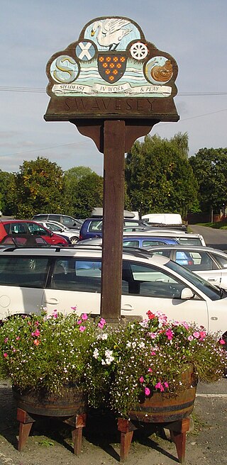
Swavesey is a village lying on the Prime Meridian in Cambridgeshire, England, with a population of 2,463. The village is situated 9 miles to the north west of Cambridge and 3 miles south east of St Ives.
Toton is a large suburban village in the Borough of Broxtowe in Nottinghamshire, England. It forms part of the built-up area of Beeston, which in turn forms part of the wider Nottingham Urban Area. The population of the electoral ward of Toton and Chilwell Meadows was 7,298 in the 2001 census; it increased to 8,238 at the 2011 census.
Comberton is a village and civil parish in South Cambridgeshire, England, just east of the Prime Meridian.

Chrishall is a small village in the English county of Essex. It is located 12 miles (20 km) south of Cambridge and lies equidistant [6 miles (10 km)] between the two medieval market towns of Saffron Walden and Royston. Although in Essex, Chrishall lies close to its borders with Hertfordshire and Cambridgeshire and has a 'Hertfordshire' postcode (SG8).

Cottenham is a village in Cambridgeshire, England. Cottenham is one of the larger villages surrounding the city of Cambridge, located around five miles north of the city. The population of the civil parish at the 2011 Census was 6,095. Cottenham is one of a number of villages that make up the historical Fen Edge region in between Cambridge and Ely, which were originally settlements on the shore of the marshes close to the city of Cambridge, then an inland port.

Teversham is a small village in Cambridgeshire, England about 2 miles (3 km) from Fulbourn and about 3 miles (5 km) from the centre of Cambridge. It is smaller than neighbouring villages. Although just a few hundred metres from the edge of Cambridge it is bordered by farmland on all sides.
Thriplow is a village in the civil parish of Thriplow and Heathfield, in Cambridgeshire, England, 8 miles (13 km) south of Cambridge. The village also gives its name to a former Cambridgeshire hundred.

Babraham is a village and civil parish in the South Cambridgeshire district of Cambridgeshire, England, about 6 miles (9.7 km) south-east of Cambridge on the A1307 road.

Fen Ditton is a village on the northeast edge of Cambridge in Cambridgeshire, England. The parish covers an area of 5.99 square kilometres (2 sq mi).

Whittlesford is a village in Cambridgeshire, England, and also the name of an old hundred. The village is situated on the Granta branch of the River Cam, seven miles south of Cambridge. Whittlesford Parkway railway station serves the village.

Freckenham is a small rural village and civil parish in the West Suffolk district of Suffolk in East Anglia, in the country of England.
Harlton is a village and civil parish in Cambridgeshire in the United Kingdom. The village is 5 miles (8.0 km) south-west of Cambridge and neighbours Haslingfield.

Kingston is a small village and parish in the East of England region and the county Cambridgeshire in the United Kingdom. Situated 7 miles to the west of Cambridge, the population at the time of the 2001 census was 214, increasing to 238 at the 2011 Census.
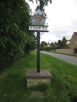
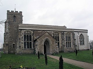
Toft is a village situated in Cambridgeshire, England. It is approximately six miles to the west of Cambridge, and is situated within four miles of the M11 motorway. It has approximately 600 residents and 200 homes. Comberton Village College and Comberton Sixth Form fall within the Toft Parish boundary. The village has two churches, St Andrew's Parish Church and Toft Methodist Church.

Elsworth is a village and civil parish in South Cambridgeshire, England, 9 miles northwest of Cambridge and 7 miles southeast of Huntingdon. At the 2011 census, the population was 726.

