The Protected areas of New South Wales include both terrestrial and marine protected areas. As of June 2020 there are 225 national parks in New South Wales. A number established since the late 1970s followed campaigns by local residents and environmentalists.
Protected areas of Tasmania consist of protected areas located within Tasmania and its immediate onshore waters, including Macquarie Island. It includes areas of crown land managed by Tasmanian Government agencies as well as private reserves. As of 2016, 52% of Tasmania's land area has some form of reservation classification, the majority is managed by the Tasmania Parks & Wildlife Service. Marine protected areas cover about 7.9% of state waters.

Big Lake is a census-designated place (CDP) in Matanuska-Susitna Borough, Alaska, United States. It is part of the Anchorage, Alaska Metropolitan Statistical Area. The population was 3,833 at the 2020 census, up from 3,350 in 2010.
Darien Lakes State Park is a 1,845-acre (7.47 km2) state park in western Genesee County, New York, near Darien Center. The park entrance is on Harlow Road, north of U.S. Route 20.

Lake Burrendong is a man-made reservoir created by Burrendong Dam. It impounds waters on the Macquarie and Cudgegong rivers, near Wellington, in the central west region of New South Wales, Australia.

Falling Waters State Park is a 171-acre (69 ha) Florida state park located three miles (5 km) south of Chipley, Washington County in northwestern Florida. The park contains a 73-foot (22 m) waterfall, the highest in the state known as "Falling Waters Falls”.

Wyangala Dam is a major gated rock fill with clay core embankment and gravity dam with eight radial gates and a concrete chute spillway across the Lachlan River, located in the south-western slopes region of New South Wales, Australia. The dam's purpose includes flood mitigation, hydro-power, irrigation, water supply and conservation. The impounded reservoir is called Lake Wyangala.
Burrendong Dam is a rock-fill embankment major gated dam with a clay core across the Macquarie River upstream of Wellington in the central west region of New South Wales, Australia. The dam's purpose includes flood mitigation, irrigation, water supply and hydro-electric power generation. The dam impounds Lake Burrendong and is filled by the waters from the Macquarie, and Cudgegong rivers as well as Meroo Creek.

Clear Lake State Park is a state park of California, United States, on Clear Lake. The park is popular for water recreation. Amenities include 149 developed campsites spread across four campground areas, two group campsites, a swimming beach with showers, a boat launch, and a marina. Since the area is a major breeding ground for grebes, there's a broad "no wake" zone in the Cole Creek launch area and near the reedy shoreline, which is conducive to canoeing and kayaking. The 590-acre (240 ha) park was established in 1949.

Blue Rock State Park is a public recreation area located 11 miles (18 km) southeast of Zanesville in Muskingum County, Ohio. The state park encompasses 322 acres (130 ha) that are surrounded by the 4,573 acres (1,851 ha) of Blue Rock State Forest.

The Kettle Moraine State Forest is a state forest in southeastern Wisconsin. The chief feature of the reserve is the Kettle Moraine, a highly glaciated area. The area contains very hilly terrain and glacial landforms, such as kettles, kames and eskers. The 56,000-acre (23,000 ha) forest is divided into two large and three small units, which are spread across a hundred miles.

Wilderness State Park is a public recreation area bordering Lake Michigan, five miles southwest of Mackinaw City in Emmet County in Northern Michigan. The state park's 10,512 acres (4,254 ha) include 26 miles (42 km) of shoreline, diverse forested dune and swale complexes, wetlands, camping areas, and many miles of hiking trails. The state park is operated by the Michigan Department of Natural Resources, which has, as of 2006, approved a proposal that 4,492 acres (1,818 ha) be officially dedicated as a wilderness area. Wilderness State Park was designated a Michigan "dark sky preserve" in 2012.

Lake Dennison Recreation Area is a 121-acre (49 ha) Massachusetts state park located in the town of Winchendon. It comprises a small portion of the 4,221 acres (1,708 ha) of the U.S. Army Corps of Engineers' Birch Hill Flood Control Project that are managed by the Department of Conservation and Recreation and that also include Otter River State Forest.

Sandy Island Beach State Park is a New York State park on the eastern shore of Lake Ontario. Its highlight is a 1,500-foot (460 m) natural sandy beach. The park is near the southern end of a notable 17-mile (27 km) length of sandy shoreline, coastal dunes, and wetlands ; a 1959 study noted that "The eastern end of Lake Ontario contains not only the finest beaches on the entire lake but also the finest wildlife habitat."
Hills Creek State Park is a 407-acre (165 ha) Pennsylvania state park in Charleston Township, Tioga County, Pennsylvania in the United States. Hills Creek Lake, a 137-acre (55 ha) man-made lake, is the focal point of the park. It is open for year-round recreation. Hills Creek State Park is in the Allegheny Plateau region of Pennsylvania, just north of U.S. Route 6 near the boroughs of Wellsboro and Mansfield.

Laurel Hill State Park is a 3,935-acre (1,592 ha) Pennsylvania state park in Jefferson and Middlecreek Townships, Somerset County, Pennsylvania in the United States. Laurel Hill Lake is a 63-acre (25 ha) man-made lake with a dam that was constructed during the Great Depression by the young men of CCC camps SP-8-PA and SP-15-PA. Laurel Hill State Park is 8 miles (13 km) from Interstate 76 just off Pennsylvania Route 31 near Bakersville and on Pennsylvania Route 653 near Trent.

Wallaga Lake is an estuarine lake in Bega Valley Shire in New South Wales, Australia, the largest lake in southern NSW. It is located between Bermagui to the south and between Tilba Tilba to the north, situated beneath Mount Gulaga, in the traditional lands of the Yuin people. A large section of its foreshore and catchment are within the Gulaga National Park, since Wallaga Lake National Park, Goura Nature Reserve, and Mt Dromedary Flora Reserve were combined into the larger national park. There is an island in the lake known as Merriman's Island, Merriman Island or Umbarra.
Sylvan Lake is located next to the community by that name in the Town of Beekman, New York, United States. It is the deepest and second-largest lake in Dutchess County.

Lucky Peak State Park is a public recreation area covering a total of 240 acres (97 ha) on and near Lucky Peak Lake approximately ten miles (16 km) east of Boise in Ada County, Idaho. The state park has three units: Discovery Park off State Highway 21, a roadside park for picnicking and fishing in the Boise River; Sandy Point at the base of the Lucky Peak Dam, with sandy beach and calm waters for wading and swimming; and the Spring Shores unit with boat ramps and marina at the northern end of the lake. The park was created in 1956 by agreement with the United States Army Corps of Engineers, following completion of the Lucky Peak Dam. The park is also home to the Lucky Peak Dam Zeolite Occurrence.
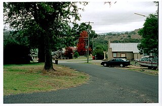
Wyangala is a small village in the Lachlan Valley, near the junction of the Abercrombie and Lachlan Rivers, just below the Wyangala Dam wall. It is in the South West Slopes of New South Wales, Australia, and about 320 km (200 mi) west of the state capital, Sydney. The name is also used for the surrounding rural locality, which includes the site of the former mining village of Mount McDonald.