Stauffer, Oregon

Last updated

Stauffer, Oregon
Stauffer, Oregon Homestead, 1915.jpg
Stauffer homestead in the winter, 1915
USA Oregon location map.svg
Red pog.svg
Stauffer
Location in Lake County and Oregon
Usa edcp location map.svg
Red pog.svg
Stauffer
Stauffer (the United States)
Coordinates: 43°29′04″N120°07′00″W / 43.48444°N 120.11667°W / 43.48444; -120.11667
CountryUnited States
State Oregon
County Lake
Elevation
4,570 ft (1,390 m)
Population
  Total0
Time zone UTC-8 (Pacific)
  Summer (DST) UTC-7 (Pacific)

Stauffer was an unincorporated community located in Lake County, Oregon, United States. The first homesteaders arrived in the area around 1910. By 1918, the local population was declining rapidly due to the harsh environment. Today, Stauffer is a ghost town with no population and no surviving structures. The site is located approximately 12 miles (19 km) south of U.S. Route 20 between Bend and Burns, Oregon. The nearest inhabited place is Hampton, Oregon, 21 miles (34 km) northwest of the Stauffer site.

Contents

Geography and environment

The Stauffer town site is in the Lost Creek Valley, in the northeast corner of Lake County. It is deep in Oregon’s remote high desert country. The site is located on an unimproved dirt road 12 miles (19 km) south of Route 20, approximately 70 miles (110 km) southeast of Bend and 50 miles (80 km) southwest of Burns. [1] [2] [3]

The elevation at the site is 4,570 feet (1,390 m) above sea level. Stauffer is just a few miles south of Glass Buttes, which is well known for its extensive obsidian deposits. The buttes are a major landmark, rising well above the surrounding high desert plain with a topographic prominence of approximately 2,000 feet (610 m). Snow melt from the southern slopes of Glass Buttes drains into the Lost Creek Valley where Stauffer is located. It was common for Stauffer area homesteaders to collect obsidian from Glass Buttes. [2] [4] [5] [6]

In the high desert country around the Stauffer site, the soil is thin and alkaline. Rainfall is limited, just 8 inches (20 cm) to 10 inches (25 cm) per year. As a result, vegetation is sparse, consisting mainly of sagebrush and bunchgrass with widely dispersed western juniper in some areas. [2] [6] [7]

Charles Stauffer

The first settlers arrived in the Stauffer area around 1910. They were drawn there by the promise of free land made available by the Homestead Act of 1909. [2] [8] Charles Albert Stauffer, his wife Maude, and their family of nine children moved to Oregon from Nebraska in 1910. After he arrived, Stauffer filed a homestead claim in the Lost Creek Valley. He quickly became a community leader. In addition to his ranch operation, Stauffer served as the community's postmaster. [1] [9] [10] He was also a notary public and a United States Land Commissioner, who processed land claims for newly arrived homesteaders. In 1914, he started a weekly newspaper called the Stauffer Enterprise, but no record of the newspaper exists today. [11] [12]

In 1918, Bill Brown, a wealthy sheep and horse rancher from neighboring Crook County, had Stauffer arrested for stealing sheep. Stauffer denied the charges, saying he was holding the sheep for a third party named Perry, who also claimed to own the animals. A grand jury decided not to indict Stauffer and all charges were dropped. Stauffer then filed a $50,000 malicious prosecution lawsuit against Brown. He later dropped the requested damages to $10,000. That claim went to trial, but the jury sided with Brown, rejecting Stauffer’s damage claim. [13] [14] [15] [16]

Stauffer and his family left the Lost Creek Valley in 1919. They relocated to Bend. A year after moving to Bend, one of Stauffer’s six sons fell ill and died at age seventeen. [17] In 1928, Charles and Maude Stauffer moved to Portland, Oregon, where they lived for the rest of their lives. Maude died there in 1936. Stauffer passed away at his home in Portland in 1943. [10] [18]

Community history

Most of the initial homesteaders in the Stauffer area lived in tents for many months waiting for lumber to be shipped in from Bend or Prineville. Other settlers cut Juniper trees on the slopes of Glass Buttes for logs to build rustic cabins. Basic food products and other supplies were delivered by freight wagon from Bend every six months, a trip that took six days each way. [2]

Once the Stauffer homesteaders were settled in, they planted backyard gardens that provided fresh vegetables. Many also brought dairy cows to their homesteads to provide milk and to use for producing cheese. Hunting rabbits, deer, and antelope on the high desert range provided meat for homestead families. Also, community rabbit drives were important events in Stauffer. To brighten up their homes, many homesteaders decorated their rustic dwellings with obsidian gathers from sites around nearby Glass Buttes. Today, many abandoned homestead sites around Stauffer are marked by piles of obsidian collected by pioneer families. [2]

Glass Buttes north of the Stauffer town site Glass Buttes, Lake County, Oregon (USFS).jpg
Glass Buttes north of the Stauffer town site

The Stauffer post office was opened on 13 September 1913. Residents originally wanted to name the post office Lost Creek. However, the United States postal system already had a post office with that name, so it was named after Charles Stauffer, who was the community’s first postmaster. [1] [19]

The community centered around the Stauffer ranch and the adjacent post office. Beyond that, the Stauffer community never developed into much of a town. It had no general store, tavern, hotel, or any public buildings except the post office and a one-room schoolhouse. Alice Brookings was the first teacher at the Stauffer school. She later became postmistress when Stauffer left that position. Brookings ran the post office until 1917, when the post office was moved back to the Stauffer ranch. [2]

A few years after the initial rush of settlers arrived between 1910 and 1913, the lack of water and the harsh freezing winters, when temperatures often dropped to −25 °F (−32 °C), forced many homesteaders to abandon their Lost Creek Valley land claims. [2] [20] [21] While mail deliveries from Bend had increased to twice a week by 1916, the exodus from the Lost Creek Valley homesteads had become pronounced. [22] By 1918, only ten Stauffer residents voted in that year’s election. Charles Stauffer and Fred Donovan delivered the ballots to the Lake County seat in Lakeview, 90 miles (140 km) south of the Lost Creek Valley. [3] [23]

By 1922, the Stauffer mail route from Bend only served 25 families along the entire 70-mile (110 km) route. [24] Over the next decade, the enrollment at Stauffer’s school continued to shrink. By 1934, there were only five students in the school. [25] The following year, the last two students left the Stauffer area and the school was closed. [26] That same year, the Stauffer post office was closed and postal serve was transferred to Hampton, which was located on the main Route 20 highway between Bend and Burns. [27] However, a postal substation was maintained at Stauffer until 1950, when all postal service to the Stauffer area was permanently discontinued. [1]

In 1943, the United States Army conducted a large-scale battle near the Stauffer town site as part of the Oregon Maneuver training exercise to prepare troops for combat in World War II. The Oregon Maneuver was one of the largest military training exercises ever conducted in the continental United States with over 100,000 soldiers and airmen participating. [2] [28]

The last resident left Lost Creek Valley sometime in the 1950s. By 1977, only a few scattered remnants of homesteader cabins remained in the valley. Today, Stauffer is a ghost town with no population and no surviving structures. The nearest inhabited place is the small unincorporated community of Hampton, Oregon, which is located 21 miles (34 km) northwest of the Stauffer site. [1] [2] [3]

Related Research Articles

<span class="mw-page-title-main">Lake County, Oregon</span> County in Oregon, United States

Lake County is one of the 36 counties in the U.S. state of Oregon. As of the 2020 census, the population was 8,160. Its county seat is Lakeview. The county is named after the many lakes found within its boundaries, including Lake Abert, Summer Lake, Hart Lake, and Goose Lake.

<span class="mw-page-title-main">Valley Falls, Oregon</span> Unincorporated community in the state of Oregon, United States

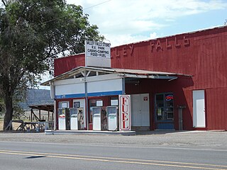
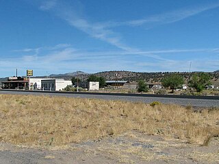
Valley Falls is a small unincorporated community in Lake County, Oregon, United States. The settled area is located at the junction of U.S. Route 395 and Oregon Route 31. The community is named for a small falls on the Chewaucan River just north of the occupied site. East of Valley Falls, the cliff face of Abert Rim overlooks the community.

<span class="mw-page-title-main">Fort Rock Valley Historical Homestead Museum</span>

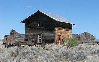
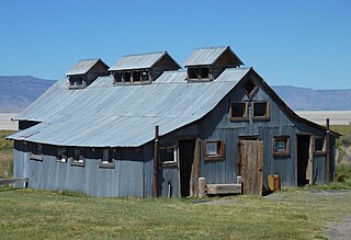
The Fort Rock Valley Historical Homestead Museum is located in Fort Rock, Oregon, United States. Opened in 1988, it is a collection of original homestead-era buildings including a church, school, houses, homestead cabins, and several other buildings assembled in a village setting. The structures were moved to the museum site from various locations around the Fort Rock Valley, named for volcanic landmark Fort Rock. Most of the buildings contain historic items used by local homesteaders including furniture, dishes, household products, and tools. The museum is open for self-guided tours from Memorial Day weekend through Labor Day weekend.

<span class="mw-page-title-main">Goose Lake Valley</span> Valley in south-central Oregon and northeastern California

The Goose Lake Valley is located in south-central Oregon and northeastern California in the United States. It is a high valley at the northwestern corner of North America's Great Basin. Much of the valley floor is covered by Goose Lake, a large endorheic lake that straddles the Oregon–California border. Native Americans inhabited the Goose Lake Valley for thousands of years before explorers arrived in the 19th century. The pioneer wagon route known as the Applegate Trail crossed the Goose Lake Valley on its way to southern Oregon. At the south end of Goose Lake, the Lassen Cutoff separated from the Applegate Trail and headed south toward the Sacramento Valley. Today, Lakeview, Oregon, is the largest settlement in the valley. Livestock ranching and lumber mills are the valley's main commercial activity. The Goose Lake Valley offers a number of recreational opportunities including hang-gliding, hunting, fishing, and birdwatching.

The Dry River is an intermittent tributary, 88 miles (142 km) long, of the Crooked River in the U.S. state of Oregon. The stream arises near Hampton Buttes north of Hampton and U.S. Route 20 between Brothers and Riley in the Oregon High Desert. Beginning in eastern Deschutes County near its border with Crook County, it flows generally northwest along the Deschutes–Crook county line, crossing briefly into Crook County before turning slightly south and returning to Deschutes County. Along these upper reaches, it flows roughly parallel to the highway, under which it passes several times before turning sharply north near the Horse Ridge Research Natural Area, 19 miles (31 km) southeast of Bend. Continuing north and re-entering Crook County, it passes under Powell Butte Highway, Oregon Route 126, and Oregon Route 370 before entering the Crooked River 34 miles (55 km) from the larger stream's confluence with the Deschutes River.

<span class="mw-page-title-main">Oregon Maneuver</span> Large scale US military training exercise

The Oregon Maneuver was a large scale military training exercise held in Central Oregon in September through November 1943. The exercise was designed to test United States Army units prior to deployment in support of Allied combat operations in World War II. The maneuver included approximately 100,000 men. The major units involved in the exercise were all part of the army's IV Corps, commanded by Major General Alexander Patch. The exercise headquarters was located at Camp Abbot, south of Bend, Oregon. The maneuver included five specific training problems that engaged troops from a defensive Red Force and an offensive Blue Force. Following the maneuver the three participating divisions, the 91st Infantry Division, the 96th Infantry Division, and the 104th Infantry Division were sent into combat in the European or the Pacific theaters.

<span class="mw-page-title-main">Hampton, Deschutes County, Oregon</span> Unincorporated community in the state of Oregon, United States

Hampton is an unincorporated community in Deschutes County, Oregon, United States. It lies about 60 miles (97 km) southeast of Bend, on U.S. Route 20, on the edge of the High Desert.

<span class="mw-page-title-main">Ray Hatton</span>

Raymond Robert (Ray) Hatton was an English educator, author, and long-distance runner. Born in England, Hatton moved to the United States in 1956 to attend college, earning degrees in education and geography from University of Idaho and the University of Oregon. He was an award-winning college geography professor for many years. Hatton wrote ten books on Oregon geography, history, and climatology. In the 1970s and 1980s, he won numerous Masters level running championships and set American records in several long-distance running events. Ran a Masters WR in the Mile at 4:26.0 in 1972. Hatton was inducted into the USATF Masters Hall of Fame in 2001.

<span class="mw-page-title-main">Catlow Valley</span>

The Catlow Valley is a basin in Harney County, Oregon, United States. It is a remote valley at the northwestern corner of North America's Basin and Range Province. The valley is named after a pioneer rancher, John Catlow. The area was used by Native Americans for thousands of years before European explorers arrived in the 19th century. Today, cattle ranching is the main commercial activity in the valley. The public land in the Catlow Valley is administered by the Bureau of Land Management. This public land offers a number of recreational opportunities including hiking, hunting, fishing, bird watching, and wildlife viewing.

<span class="mw-page-title-main">Fossil Lake (Oregon)</span> Dry lakebed and fossil site in the U.S. state of Oregon

Fossil Lake is a dry lakebed in the remote high desert country of northern Lake County in the U.S. state of Oregon. During the Pleistocene epoch, Fossil Lake and the surrounding basin were covered by an ancient lake. Numerous animals used the lake's resources. Over time, the remains of many of these animals became fossilized in the lake sediments. As a result, Fossil Lake has been an important site for fossil collection and scientific study for well over a century. Over the years, paleontologists have found the fossil remains of numerous mammals as well as bird and fish species there. Some of these fossils are 2 million years old.

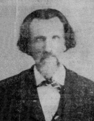
Charles William Emanuel Jennings, known as Pop Jennings, was a businessman and Oregon state legislator. He was an early settler in the Chewaucan Valley in south-central Oregon, where he established the community of Valley Falls. Jennings was also a Democratic member of the Oregon House of Representatives for one term, serving from 1937 through 1938.

<span class="mw-page-title-main">Lava bear</span> Subspecies of bear in North America

The lava bear is a variety of American black bear found in the lava beds of south central Oregon. The animal was described as a very small bear with wooly light brown fur. The few lava bears that were killed or captured were a little larger than a badger. It was once thought to be a separate species. However, scientists who examined the specimens determined that the animals were stunted due to the harsh environment in which they lived. Today, it is acknowledged that lava bears never existed as a unique species.

<span class="mw-page-title-main">Glass Buttes</span>

Glass Buttes are a group of volcanic mountains made up of two prominent peaks and several smaller hills. They are located in the remote northeast corner of Lake County between Bend and Burns in central Oregon, United States. Raising high above the high desert plain, the buttes are an important landmark in an area once known as the Oregon's Great Sandy Desert. The buttes are named for the numerous large deposits of obsidian found on their slopes. Today, most of the mountains and surrounding land are administered by the Bureau of Land Management. The mountains offer a number of recreational opportunities including rock collecting, hiking, camping, and hunting.

<span class="mw-page-title-main">Cline Buttes</span> Mountains in central Oregon, US

The Cline Buttes are mountains with volcanic origins that form three dome-shaped peaks located in Deschutes County in central Oregon. They are some of the eastern foothills of the Cascade Range. Situated on land administered by the Bureau of Land Management, the buttes are flanked on the east and west sides by two separate sections of the Eagle Crest Resort. On the highest summit, there is a Federal Aviation Administration site with an aircraft navigation beacon. The mountains have several hiking trails as well as a number of popular mountain bike routes.

<span class="mw-page-title-main">Summer Lake Hot Springs</span> Thermal springs in Oregon

Summer Lake Hot Springs are natural hot springs at the south end of Summer Lake in south-central Oregon. They are artesian mineral springs with four surface sources. The springs have complex water chemistry. The temperature of the main source is approximately 123 °F (51 °C) with a water flow of approximately 20 US gallons (76 L) per minute. Over the years, the site has been developed as a rustic family bathing and relaxation resort. The hot springs are 124 miles (200 km) southeast of Bend, Oregon, near the small town of Paisley, Oregon.

<span class="mw-page-title-main">Barney Prine</span> American pioneer

Francis Barnett Prine was an American pioneer who was one of the first settlers to homestead in the Ochoco country of central Oregon. When he was young, Prine traveled with his family from Missouri to Oregon's Willamette Valley over the Oregon Trail. He served in the 1st Oregon Volunteer Infantry Regiment during the American Civil War. Prine later moved to the Central Oregon, where he established several businesses in what became Prineville, Oregon, a town named in his honor.

<span class="mw-page-title-main">Cass A. Cline</span>

Cass Adelbert Cline was an American pioneer who was an early settler in central Oregon. Cline’s family moved to Oregon when he was a small child, settling west of the Cascade Mountains near Roseburg. As a young man, Cline moved to central Oregon and claimed homestead land along the Deschutes River. He later became a well-known dentist, property developer, and race horse breeder. Today, a waterfall on the Deschutes River, a nearby mountain group, and a state park bear his name.

<span class="mw-page-title-main">Vernon A. Forbes</span> American politician

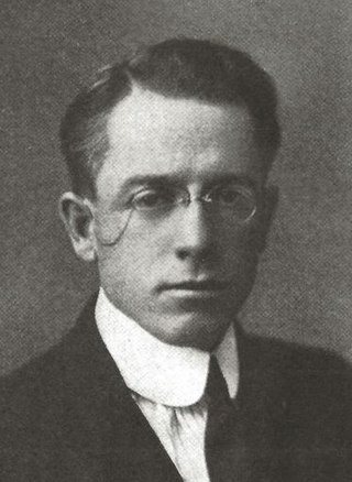
Vernon A. Forbes was an American attorney and state legislator from the state of Oregon. After graduation from law school in Minnesota, he moved to central Oregon and opened a law office in the city of Bend. Forbes was a Republican who served three two-year terms in the Oregon House of Representatives, representing Crook, Deschutes, Grant, Jefferson, Klamath, and Lake counties. He drowned during a fishing trip near the end of his third term in the legislature.

<span class="mw-page-title-main">Fremont, Oregon</span> Ghost town in Oregon, United States

Fremont was an unincorporated community located in Lake County, Oregon, United States. The first homesteaders arrived in the area around Fremont in 1905. The population grew quickly, and the Fremont post office was opened in 1908. By 1915, the local population was declining rapidly due to a severe drought that dried up surface water and lowered the water table in the area around Fremont. Today, Fremont is a ghost town with no population and no surviving structures. The site is located approximately 5 miles (8.0 km) west of Fort Rock state park. The nearest inhabited place is the small unincorporated community of Fort Rock, Oregon, which is 6 miles (9.7 km) southeast of the Fremont townsite.

<span class="mw-page-title-main">Fleetwood, Oregon</span> Ghost town in Oregon, United States

Fleetwood was an unincorporated community located in Lake County, Oregon, United States. The first homesteaders arrived in the area around Fleetwood in 1905. The Fleetwood post office was opened in 1913. By 1920, the local population was declining due to a severe drought that dried up surface water and lowered the water table in the area around Fleetwood. Today, Fleetwood is a ghost town with no population and no surviving structures at the townsite. The site is located approximately 10 miles (16 km) east of Fort Rock state park. The nearest inhabited place is the small unincorporated community of Fort Rock, Oregon, which is 9 miles (14 km) west of the Fleetwood townsite.

References

  1. 1 2 3 4 5 McArthur, Lewis A. and Lewis L. McArthur, "Stauffer", Oregon Geographic Names (Seventh Edition), Oregon Historical Society Press, Portland, Oregon, 2003, p. 910.
  2. 1 2 3 4 5 6 7 8 9 10 Hatton, Raymond R., High Desert of Central Oregon, Binford and Mort, Portland, Oregon, 1981, pp. 72–81.
  3. 1 2 3 Oregon topographic map, United States Geological Survey, United States Department of Interior, Reston, Virginia; displayed via ACME mapper, www.acme.com, 22 November 2016.
  4. McArthur, Lewis A. and Lewis L. McArthur, "Glass Buttes", Oregon Geographic Names (Seventh Edition), Oregon Historical Society Press, Portland, Oregon, 2003, p. 404.
  5. Russell, Israel C., "Glass Buttes", Preliminary Report on the Geology and Water Resources of Central Oregon, United States Geological Survey, United States Department of Interior, Government Printing Office, Washington, District of Columbia, 1905, p. 49.
  6. 1 2 Brogan, Phil F., East of the Cascades, Binfords and Mort, Portland, Oregon, 1965, p. 268-269.
  7. Hatton, Raymond R., High Desert of Central Oregon, Binford and Mort, Portland, Oregon, 1981, pp. 1–2.
  8. LaLande, Jeff, "Dry-Farm Homesteading", Oregon History Project, Oregon Historical Society, Portland, Oregon, 17 March 2018.
  9. "Stauffer", Bend Bulletin, Bend, Oregon, 28 April 1915, p. 2.
  10. 1 2 "C. J. Stauffer, Pioneer, Dies", Bend Bulletin, Bend, Oregon, 10 March 1943, p. 1.(subscription required)
  11. "Hampton Butte", Bend Bulletin, Bend, Oregon, 11 March 1914, p. 2.
  12. "Newspaper at Stauffer", Lake County Examiner, Lakeview, Oregon, 11 June 1914, p. 2.
  13. "Held for Grand Jury for Theft of Sheep", Bend Bulletin, Bend, Oregon, 11 June 1918, p. 1.(subscription required)
  14. "Heavy Damages Suit is Filed", Bend Bulletin, Bend, Oregon, 15 October 1918, p. 1.(subscription required)
  15. "Curcuit Court Term Nearing", Bend Bulletin, Bend, Oregon, 21 March 1919, p. 1.(subscription required)
  16. "With the Exchanges", Crook County Journal, Prineville, Oregon, 8 June 1919, p. 4.
  17. "Funeral is Held for Ted Stauffer", Bend Bulletin, Bend, Oregon, 8 November 1920, p. 3.(subscription required)
  18. "Mrs C. J. Stauffe, Lake Pioneer, Dies", Bend Bulletin, Bend, Oregon, 18 January 1936, p. 3.(subscription required)
  19. "Hampton", Bend Bulletin, Bend, Oregon, 2 April 1913, p. 8.(subscription required)
  20. "Stauffer", Bend Bulletin, Bend, Oregon, 30 December 1914, p. 2.
  21. "Water Shortage at Stauffer", Bend Bulletin, Bend, Oregon, 12 June 1918, p. 2.(subscription required)
  22. "Mail Change is Provided For", Bend Bulletin, Bend, Oregon, 11 October 1916, p. 2.
  23. "Stauffer Cast a Light Vote", Bend Bulletin, Bend, Oregon, 14 November 1918, p. 2.
  24. "Bend Distribution Point for Mail for Vast Inland Area", Bend Bulletin, Bend, Oregon, 8 June 1922, p. 6.
  25. "Stauffer School Year Opens with Five Pupils", Bend Bulletin, Bend, Oregon, 30 September 1934, p. 6.(subscription required)
  26. "Stauffer", Bend Bulletin, Bend, Oregon, 14 August 1935, p. 5.(subscription required)
  27. "Stauffer Post Office to be Discontinued", Bend Bulletin, Bend, Oregon, 25 February 1935, p. 4.(subscription required)
  28. "Highlands South of Stauffer Scene of 4th Oregon Battle", Bend Bulletin, Bend, Oregon, 5 October 1943, p. 1.(subscription required)