
Chandler is a city in Maricopa County, Arizona, United States, and a suburb in the Phoenix-Mesa-Chandler Metropolitan Statistical Area (MSA). It is bordered to the north and west by Tempe, to the north by Mesa, to the west by Phoenix, to the south by the Gila River Indian Community, and to the east by Gilbert. As of the 2020 census, the population of Chandler was 279,458, up from 236,123 at the 2010 census.

Litchfield Park is a city in Maricopa County, Arizona, United States. It is located 19 miles (31 km) west of Phoenix. As of the 2020 census, the population of the city was 6,847, up from 5,476 in 2010.

Scottsdale is a city in the eastern part of Maricopa County, Arizona, United States, and is part of the Phoenix metropolitan area. Named Scottsdale in 1894 after its founder Winfield Scott, a retired U.S. Army chaplain, the city was incorporated in 1951 with a population of 2,000. At the 2020 census, the population was 241,361, which had grown from 217,385 in 2010. Its slogan is "The West's Most Western Town". Over the past two decades, it has been one of the fastest growing cities in the United States.

Camp Verde is a town in Yavapai County, Arizona, United States. As of the 2010 census, the population of the town is 10,873.
Indigenous peoples of Arizona are the Native American people who currently live or have historically lived in what is now the state of Arizona. There are 22 federally recognized tribes in Arizona, including 17 with reservations that lie entirely within its borders. Reservations make up over a quarter of the state's land area. Arizona has the third largest Native American population of any U.S. state.

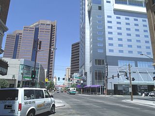
Downtown Phoenix is the central business district (CBD) of the City of Phoenix, Arizona, United States. It is in the heart of the Phoenix metropolitan area or Valley of the Sun. Phoenix, being the county seat of Maricopa County and the capital of Arizona, serves as the center of politics, justice and government on the local, state and federal levels. The area is a major center of employment for the region, with many financial, legal, and other national and international corporations housed in a variety of skyscrapers. Major arts and cultural institutions also call the area home. Downtown Phoenix is a center of major league sports activities, live concert events, and is an equally prominent center of banking and finance in Arizona. Regional headquarters for several major banks, including JP Morgan Chase, Wells Fargo, US Bank, Bank of America, Compass Bank and Midfirst Bank are all located within or close proximity to the area.

Encanto Village is one of the 15 Urban villages that make up the City of Phoenix, in Arizona. The village includes the city's midtown and uptown districts, as well as the popular Encanto neighborhood, its namesake. In 2010, Encanto had a population of 54,614 residents.
The Central Avenue Corridor is a significant stretch of north–south Central Avenue in Phoenix, Arizona. Roughly bounded by Camelback Road to its north, and McDowell Road to its south, this is one of Phoenix's most vital and heavily trafficked stretches of roads. It is also one of the region's largest centers of employment, with nearly 60,000 people being employed within a three-mile (5 km) radius of this swath of Central Avenue. Major employers here include major banks and financial institutions, hi-tech companies, and several significant law firms and government agencies.

Phoenix Pride is a parade and festival held each year in Phoenix, Arizona to celebrate the lesbian, gay, bisexual, and transgender (LGBT) people and their allies.
Many arterial roads in the Phoenix metropolitan area have the same name in multiple cities or towns. Some roads change names or route numbers across town borders, resulting in occasional confusion. For example, the road known as Apache Boulevard in Tempe continues east as Main Street in neighboring Mesa and then as Apache Trail in Apache Junction. Although Broadway Road maintains the same name through Goodyear, Avondale, Phoenix, Tempe, Mesa, and Apache Junction, each town uses a different reference point for address numbers.
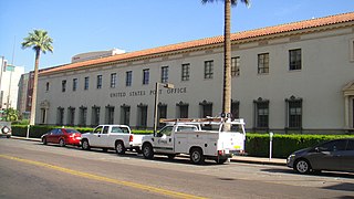
The U.S. Post Office at 522 North Central Avenue at 1st Avenue and West Fillmore Street in Phoenix, Arizona, also known as the Federal Building-U.S. Post Office, is a building of the United States federal government that was built in 1932-1936 and designed by Lescher and Mahoney in the Spanish Colonial Revival style. It was added to the National Register of Historic Places in 1983. It is currently part of Arizona State University's Downtown Phoenix Campus, where it houses student organizations, counseling services, administrative offices and the ASU Police Department. A USPS location is situated on the first floor of the old post office.

Phoenix Union High School (PUHS) was a high school that was part of the Phoenix Union High School District in downtown Phoenix, Arizona, one of five high school-only school districts in the Phoenix area. Founded in 1895 and closed in 1992, the school consisted of numerous buildings on a campus which by 1928 consisted of 18 acres.
Carver High School was a public high school in Phoenix, Arizona, established to serve African-American students during a time of school segregation.

The Phoenix Indian School, or Phoenix Indian High School in its later years, was a Bureau of Indian Affairs-operated school in Encanto Village, in the heart of Phoenix, Arizona. It served lower grades also from 1891 to 1935, and then served as a high school thereafter. It opened in 1891 and closed in 1990 on the orders of the federal government. During its existence, it was the only non-reservation BIA school in Arizona.

The Schoolhouse at Truxton Canyon Training School, which has also been known as the Truxton Canyon Indian School and as the Valentine Indian School, is a historic schoolhouse that was built in 1903. It was built using Colonial Revival architecture as a work of the Office of Indian Affairs, and was expanded, compatibly with the Colonial Revival style, in 1929. It was listed on the National Register of Historic Places in 2003.

The Deer Valley Petroglyph Preserve, formerly known as the Deer Valley Rock Art Center, is a 47-acre nature preserve featuring over 1500 Hohokam, Patayan, and Archaic petroglyphs visible on 500 basalt boulders in the Deer Valley area of Phoenix, Arizona. In 1980, the US Army Corps of Engineers contracted J. Simon Bruder to conduct an archaeological investigation prior to the construction of the Adobe Dam at the Hedgpeth Hills. The petroglyphs are between 500 and 5,000 years old. The site was listed on the National Register of Historic Places in 1984, and it was also listed with the Phoenix Points of Pride. The preserve and museum are operated by the ASU College of Liberal Arts and Sciences's School of Human Evolution and Social Change.

Fort Apache Historic Park is a tribal historic park of the White Mountain Apache, located at the former site of Fort Apache on the Fort Apache Indian Reservation. The park interprets the rich and troubled history of relations between the Apache and other Native American tribes at the fort, which was converted into a Bureau of Indian Affairs boarding school after its military use ended. The park, which covers 288 acres (117 ha) of the former fort and school, as well as a nearby military cemetery, form the National Historic Landmark Fort Apache and Theodore Roosevelt School historic district.

Greenwood Memory Lawn Mortuary & Cemetery is the official name given to a cemetery located at 2300 West Van Buren Street in Phoenix, Arizona owned by Dignity Memorial. The cemetery, which resulted as a merger of two historical cemeteries, Greenwood Memorial Park and Memory Lawn Memorial Park, is the final resting place of various notable former residents of Arizona. Pioneers, governors, congressman, government officials, journalists, race car drivers, soldiers, actors and actresses are among the many notable decedents who are interred in the cemetery.
 Historic Phoenix Indian School
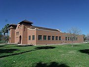 Different view of the historic Indian School.
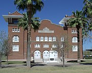 Memorial Hall (built 1922)
 World War I War Memorial
 The Indian School Band Building built in 1931 and located in the compounds of Phoenix’s Steele Indian School Park in 300 E. Indian School Rd.


