A coast – also called the coastline, shoreline, or seashore – is the land next to the sea or the line that forms the boundary between the land and the ocean or a lake. Coasts are influenced by the topography of the surrounding landscape, as well as by water induced erosion, such as waves. The geological composition of rock and soil dictates the type of shore that is created. Earth contains roughly 620,000 km (390,000 mi) of coastline.

Tides are the rise and fall of sea levels caused by the combined effects of the gravitational forces exerted by the Moon and are also caused by the Earth and Moon orbiting one another.
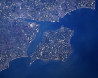
The Solent is a strait between the Isle of Wight and mainland Great Britain; the major historic ports of Southampton and Portsmouth lie inland of its shores. It is about 20 miles long and varies in width between 2+1⁄2 and 5 mi, although the Hurst Spit which projects 1+1⁄2 mi (2.4 km) into the Solent narrows the sea crossing between Hurst Castle and Colwell Bay to just over 1 mi (1.6 km).

The littoral zone, also called litoral or nearshore, is the part of a sea, lake, or river that is close to the shore. In coastal ecology, the littoral zone includes the intertidal zone extending from the high water mark, to coastal areas that are permanently submerged — known as the foreshore — and the terms are often used interchangeably. However, the geographical meaning of littoral zone extends well beyond the intertidal zone to include all neritic waters within the bounds of continental shelves.

A tide pool or rock pool is a shallow pool of seawater that forms on the rocky intertidal shore. These pools typically range from a few inches to a few feet deep and a few feet across. Many of these pools exist as separate bodies of water only at low tide, as seawater gets trapped when the tide recedes. Tides are caused by the gravitational pull of the sun and moon. A tidal cycle is usually about 25 hours and consists of two high tides and two low tides.
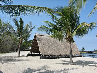
Kaloko-Honokōhau National Historical Park is a United States National Historical Park located in the Kona District on the Big island of Hawaiʻi in the U.S. state of Hawaiʻi. It includes the National Historic Landmarked archaeological site known as the Honokōhau Settlement. The park was established on November 10, 1978, for the preservation, protection and interpretation of traditional native Hawaiian activities and culture.

A fishing weir, fish weir, fishgarth or kiddle is an obstruction placed in tidal waters, or wholly or partially across a river, to direct the passage of, or trap fish. A weir may be used to trap marine fish in the intertidal zone as the tide recedes, fish such as salmon as they attempt to swim upstream to breed in a river, or eels as they migrate downstream. Alternatively, fish weirs can be used to channel fish to a particular location, such as to a fish ladder. Weirs were traditionally built from wood or stones. The use of fishing weirs as fish traps probably dates back prior to the emergence of modern humans, and have since been used by many societies around the world.

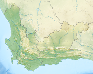
Stilbaai, also known as the Bay of Sleeping Beauty, is a town along the southern coast of South Africa about four hours by car from Cape Town. It is part of the Hessequa Local Municipality in the Western Cape province.

The intertidal zone or foreshore is the area above water level at low tide and underwater at high tide; in other words, it is the part of the littoral zone within the tidal range. This area can include several types of habitats with various species of life, such as sea stars, sea urchins, and many species of coral with regional differences in biodiversity. Sometimes it is referred to as the littoral zone or seashore, although those can be defined as a wider region.
Australian archaeology is a large sub-field in the discipline of archaeology. Archaeology in Australia takes four main forms: Aboriginal archaeology, historical archaeology, maritime archaeology and the archaeology of the contemporary past. Bridging these sub-disciplines is the important concept of cultural heritage management, which encompasses Aboriginal and Torres Strait Islander sites, historical sites, and maritime sites.
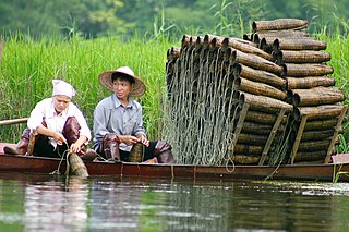
A fish trap is a trap used for catching fish and other aquatic animals of value. Fish traps include fishing weirs, cage traps, fish wheels and some fishing net rigs such as fyke nets.

The food of the Tlingit people, an indigenous group of people from Alaska, British Columbia, and the Yukon, is a central part of Tlingit culture, and the land is an abundant provider. A saying amongst the Tlingit is that "When the tide goes out the table is set." This refers to the richness of intertidal life found on the beaches of Southeast Alaska, most of which can be harvested for food. Another saying is that "in Lingít Aaní you have to be an idiot to starve". Since food is so easy to gather from the beaches, a person who cannot feed himself at least enough to stay alive is considered a fool, perhaps mentally incompetent or suffering from very bad luck. Though eating off the beach could provide a fairly healthy and varied diet, eating nothing but "beach food" is considered contemptible among the Tlingit, and a sign of poverty. Shamans and their families were required to abstain from all food gathered from the beach, and men might avoid eating beach food before battles or strenuous activities in the belief that it would weaken them spiritually and perhaps physically as well. Thus for both spiritual reasons as well as to add some variety to the diet, the Tlingit harvest many other resources for food besides what they easily find outside their front doors. No other food resource receives as much emphasis as salmon; however, seal and game are both close seconds.
Llanon is a village in Ceredigion, Wales. It adjoins the village of Llansantffraed on the coast of Cardigan Bay, 5 mi (8.0 km) north of Aberaeron and 11 miles (18 km) south of Aberystwyth on the A487 road. It is situated on a raised beach. The village is named after the church of Saint Non (Llan-Non), the mother of Saint David. By tradition, St David was born and brought up in Llanon.
This is a glossary of terms used in fisheries, fisheries management and fisheries science.

In archeological literature, the name Boylston Street Fishweir refers to ancient fishing structures first discovered in 1913, buried 29 to 40 feet below Boylston Street in Boston, Massachusetts. Reports written in 1942 and 1949 describe what was thought to be remains of one large fishweir, 2,500 years old, made of up to 65,000 wooden stakes distributed over an estimated 2 hectares of the former mud flat and marshland in what is now the Back Bay section of Boston. A different interpretation of these findings is offered by new evidence and contemporary archeological research techniques.

Aboriginal sites of Victoria form an important record of human occupation for probably more than 40,000 years. They may be identified from archaeological remains, historical and ethnographic information or continuing oral traditions and encompass places where rituals and ceremonies were performed, occupation sites where people ate, slept and carried out their day to day chores, and ephemeral evidence of people passing through the landscape, such as a discarded axe head or isolated artefact.
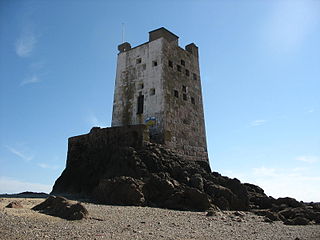
Seymour Tower is a coastal defence tower built on a rocky tidal island called L'Avarison, located 2 km east of the shoreline of Jersey, an area included in Jersey's South-East coast Ramsar site. Acquired by Jersey Heritage in 2006, it has since been used for self-catering accommodation.

The Menai Strait fish weirs are historically important fishing traps used in the fast-flowing tidal waters of the Menai Strait, which separates Anglesey from the rest of North Wales. The strait was particularly well suited to utilising fish weirs. The tidal waters pull huge volumes of water past the coastline with every tide, and the weirs and traps enabled fish to be concentrated into small holding areas from which they can be readily caught. Such methods are thought to have been used from earliest times, but the submerged and standing remains along both the Anglesey and Gwynedd coasts are from medieval and post-medieval periods, and in some cases were still in use into the 20th century.

Llanddona fish weir is a post-medieval fish trap sited in Llanddona, on the Isle of Anglesey. The fish weir is a scheduled monument.
Balcreuchan Port or Balcruachan Port (NX0908878) is a bay and raised beach site in the parish of Colmonell, close to Bennane Head and Port Vad (NX091870) in South Ayrshire, Scotland. It is well known for its cave (NX099876) with its links to the legend of Sawney Bean and also for the unusual geology that is found in the bay. It was a minor fishing harbour up until the mid to late 19th century.