A waterfall is a point in a river or stream where water flows over a vertical drop or a series of steep drops. Waterfalls also occur where meltwater drops over the edge of a tabular iceberg or ice shelf.
A glen is a valley, typically one that is long and bounded by gently sloped concave sides, unlike a ravine, which is deep and bounded by steep slopes. Whittow defines it as a "Scottish term for a deep valley in the Highlands" that is "narrower than a strath". The word is Goidelic in origin: gleann in Irish and Scottish Gaelic, glion in Manx. The designation "glen" also occurs often in place names.

"Waterfalls" is a song by American hip-hop group TLC. It was written by Marqueze Etheridge and Organized Noize with a verse by TLC's Lisa "Left Eye" Lopes, for their second album CrazySexyCool (1994), with production by Organized Noize. The song was the third single released from the album on May 29, 1995, in the United States, followed by a United Kingdom release on August 5, 1995.

Glen Nevis is a glen in Lochaber, Highland, Scotland, with Fort William at its foot. It is bordered to the south by the Mamore range, and to the north by the highest mountains in the British Isles: Ben Nevis, Càrn Mor Dearg, Aonach Mòr, and Aonach Beag. It is home to one of the three highest waterfalls in Scotland, Steall Falls, where the Allt Coire a'Mhail joins the Water of Nevis in the glen. Below the waterfall is a steeply walled and impressive gorge. The scenic beauty of the glen has led to its inclusion the Ben Nevis and Glen Coe National Scenic Area, one of 40 such areas in Scotland.

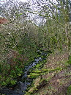
The River Stinchar is a river in South Ayrshire, Scotland. It flows south west from the Galloway Forest Park to enter the Firth of Clyde at Ballantrae, about 20 kilometres south-southeast of Ailsa Craig.
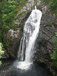
The Fall of Foyers is a waterfall on the River Foyers, which feeds Loch Ness, in Highland, Scotland, United Kingdom. It is located on the lower portion of the River Foyers, and drops 165 feet (50 m).
Barr is a village in the South West of Ayrshire, Scotland, approximately 8 miles (13 km) from the town of Girvan. There are various opinions as to the origins of the name. The most likely is the Gaelic bàrr meaning 'a hill-top, a height'. It is believed to have been established in the 17th century by smugglers who needed a safe place close to the secluded bays of the Ayrshire coast while having access to the Raiders Road which runs close by. Barr has not changed much since that time. Currently Barr Village has a population of approximately 110, while the total for the Parish of Barr is in the region of 260.
In geology, the Llandeilo Group is the middle subdivision of the British Ordovician rocks. It was first described and named by Sir Roderick Murchison from the neighborhood of Llandeilo in Carmarthenshire. In the type area it consists of a series of slaty rocks, shales, calcareous flagstones and sandstones; the calcareous middle portion is sometimes termed the Llandeilo limestone; and in the upper portion volcanic rocks are intercalated.

Kinloch Rannoch is a village in Perth and Kinross, Scotland, at the eastern end of Loch Rannoch, 18 miles (29 km) west of Pitlochry, on the banks of the River Tummel. The village is a tourist and outdoor pursuits centre. It has a small population and is fairly remote.

Torc Mountain, at 535 metres (1,755 ft), is the 329th–highest peak in Ireland on the Arderin list. It is a popular mountain for hill walkers as it has a stone or boarded path from its base at Torc Waterfall to its summit, which has views of the Lakes of Killarney. Torc Mountain is part of the Mangerton Mountain Group range in County Kerry, Ireland.

Colmonell is a small village and civil parish in the Stinchar Valley, South Ayrshire, Scotland. The nearest town is Girvan, 11 miles away.
Barrhill is a village in South Ayrshire, Scotland with a population of approximately 400 in 2001.

The Teviot Falls is a plunge waterfall in the Darling Downs region of Queensland, Australia.

The Southern Uplands Fault is a fault in Scotland that runs from Girvan to Dunbar on the East coast. It marks the southern boundary of the Scottish Midland Valley and the northern margin of the Southern Uplands; indeed it is recognised as a boundary between these two terranes. Both sinistral and dextral strike-slip movement is recorded from parts of the fault as are down-north and down-south normal movements suggestive of a complex history.
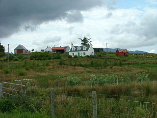
Ellishadder is a crofting township, situated close to the north shore of the freshwater Loch Mealt, on the Trotternish peninsula of the island of Skye, and is in the Scottish council area of Highland. Ellishadder is one of 23 townships making up the district area of Staffin.

Eas a' Chrannaig also known as the Glenashdale Falls is a waterfall on the island of Arran, Scotland. There are a series of falls on the Glenashdale Burn, which flows from moorland near the summit of Tighvein eastwards towards Whiting Bay, from which there is a tourist trail leading some 4 kilometres (2.5 mi) up Glenashdale.

Waterfall railway station was the first intermediate stop on the Snowdon Mountain Railway, located on the southern edge of Llanberis, Gwynedd, Wales.
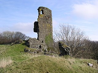
Ardstinchar Castle is a late medieval castle in the west coast of Ayrshire at the mouth of the River Stinchar. It was built by Hugh Kennedy of Ardstinchar in the mid-15th century. In the 1770s, the castle was demolished and the stone was used to build a bridge over the River Stinchar. Only remnants of the castle keep remain to this day. The site is a scheduled monument.