
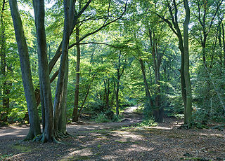
A forest is an ecosystem characterized by a dense community of trees. Hundreds of definitions of forest are used throughout the world, incorporating factors such as tree density, tree height, land use, legal standing, and ecological function. The United Nations' Food and Agriculture Organization (FAO) defines a forest as, "Land spanning more than 0.5 hectares with trees higher than 5 meters and a canopy cover of more than 10 percent, or trees able to reach these thresholds in situ. It does not include land that is predominantly under agricultural or urban use." Using this definition, Global Forest Resources Assessment 2020 found that forests covered 4.06 billion hectares, or approximately 31 percent of the world's land area in 2020.

Coppicing is the traditional method in woodland management of cutting down a tree to a stump, which in many species encourages new shoots to grow from the stump or roots, thus ultimately regrowing the tree. A forest or grove that has been subject to coppicing is called a copse or coppice, in which young tree stems are repeatedly cut down to near ground level. The resulting living stumps are called stools. New growth emerges, and after a number of years, the coppiced trees are harvested, and the cycle begins anew. Pollarding is a similar process carried out at a higher level on the tree in order to prevent grazing animals from eating new shoots. Daisugi, is a similar Japanese technique.
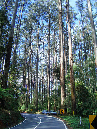
Eucalyptus regnans, known variously as mountain ash, swamp gum, or stringy gum, is a species of medium-sized to very tall forest tree that is native to the Australia states of Tasmania and Victoria. It is a straight-trunked tree with smooth grey bark, but with a stocking of rough brown bark at the base, glossy green, lance-shaped to curved adult leaves, flower buds in groups of between nine and fifteen, white flowers, and cup-shaped or conical fruit. It is the tallest of all flowering plants; the tallest measured living specimen, named Centurion, stands 100 metres tall in Tasmania.
Tree planting is the process of transplanting tree seedlings, generally for forestry, land reclamation, or landscaping purposes. It differs from the transplantation of larger trees in arboriculture and from the lower-cost but slower and less reliable distribution of tree seeds. Trees contribute to their environment over long periods of time by providing oxygen, improving air quality, climate amelioration, conserving water, preserving soil, and supporting wildlife. During the process of photosynthesis, trees take in carbon dioxide and produce the oxygen we breathe.

The longleaf pine is a pine species native to the Southeastern United States, found along the coastal plain from East Texas to southern Virginia, extending into northern and central Florida. In this area it is also known as "yellow pine" or "long leaf yellow pine", although it is properly just one out of a number of species termed yellow pine. It reaches a height of 30–35 m (98–115 ft) and a diameter of 0.7 m (28 in). In the past, before extensive logging, they reportedly grew to 47 m (154 ft) with a diameter of 1.2 m (47 in). The tree is a cultural symbol of the Southern United States, being the official state tree of Alabama. This particular species is one of the eight pine tree species that falls under the "Pine" designation as the state tree of North Carolina.
Silviculture is the practice of controlling the growth, composition/structure, as well as quality of forests to meet values and needs, specifically timber production.

An old-growth forest is a forest that has developed over a long period of time without disturbance. Due to this, old-growth forests exhibit unique ecological features. The Food and Agriculture Organization of the United Nations defines primary forests as naturally regenerated forests of native tree species where there are no clearly visible indications of human activity and the ecological processes are not significantly disturbed. One-third of the world's forests are primary forests. Old-growth features include diverse tree-related structures that provide diverse wildlife habitats that increases the biodiversity of the forested ecosystem. Virgin or first-growth forests are old-growth forests that have never been logged. The concept of diverse tree structure includes multi-layered canopies and canopy gaps, greatly varying tree heights and diameters, and diverse tree species and classes and sizes of woody debris.
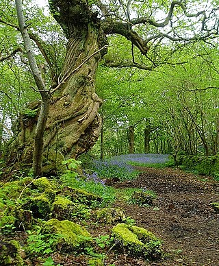
In the United Kingdom, ancient woodland is that which has existed continuously since 1600 in England, Wales and Northern Ireland. Planting of woodland was uncommon before those dates, so a wood present in 1600 is likely to have developed naturally.
The following outline is provided as an overview of and guide to forestry:
Basal area is the cross-sectional area of trees at breast height. It is a common way to describe stand density. In forest management, basal area usually refers to merchantable timber and is given on a per hectare or per acre basis. If you cut down all the merchantable trees on an acre at 4 ½ feet off the ground and measured the square inches on the top of each stump (πr*r), added them all together and divided by square feet, that would be the basal area on that acre. In forest ecology, basal area is used as a relatively easily-measured surrogate of total forest biomass and structural complexity, and change in basal area over time is an important indicator of forest recovery during succession .
Forest farming is the cultivation of high-value specialty crops under a forest canopy that is intentionally modified or maintained to provide shade levels and habitat that favor growth and enhance production levels. Forest farming encompasses a range of cultivated systems from introducing plants into the understory of a timber stand to modifying forest stands to enhance the marketability and sustainable production of existing plants.
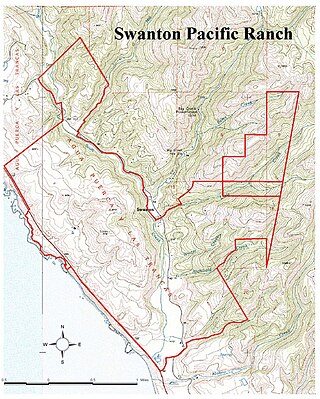
Swanton Pacific Ranch is a 3,200-acre (1,300 ha) ranch in Santa Cruz County, California, outside the town of Davenport. The ranch is owned and operated by California Polytechnic State University for educational and research in sustainable agriculture. The ranch encompasses rangeland, livestock, and forestry operations for the College of Agriculture, Food and Environmental Sciences, comprises a significant part of the community of Swanton, and includes the lower Scott Creek watershed.
Site index is a term used in forestry to describe the potential for forest trees to grow at a particular location or "site". Site is defined as "The average age of dominate and/or codominate trees of an even-aged, undisturbed site of intolerant trees at a base age"; furthermore, the word site is used in forestry to refer to a distinct area where trees are found. Site index is used to measure the productivity of the site and the management options for that site and reports the height of dominant and co-dominant trees in a stand at a base age such as 25, 50 and 100 years. For example, a red oak with an age of 50 years and a height of 70 feet (21 m) will have a site index of 70. Site index is species specific. Common methods used to determine site index are based on tree height, plant composition and the use of soil maps.

Tree allometry establishes quantitative relations between some key characteristic dimensions of trees and other properties. To the extent these statistical relations, established on the basis of detailed measurements on a small sample of typical trees, hold for other individuals, they permit extrapolations and estimations of a host of dendrometric quantities on the basis of a single measurements.
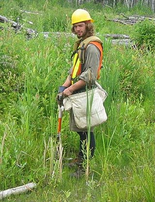
Forest inventory is the systematic collection of data and forest information for assessment or analysis. An estimate of the value and possible uses of timber is an important part of the broader information required to sustain ecosystems. When taking forest inventory the following are important things to measure and note: species, diameter at breast height (DBH), height, site quality, age, and defects. From the data collected one can calculate the number of trees per acre, the basal area, the volume of trees in an area, and the value of the timber. Inventories can be done for other reasons than just calculating the value. A forest can be cruised to visually assess timber and determine potential fire hazards and the risk of fire. The results of this type of inventory can be used in preventive actions and also awareness. Wildlife surveys can be undertaken in conjunction with timber inventory to determine the number and type of wildlife within a forest. The aim of the statistical forest inventory is to provide comprehensive information about the state and dynamics of forests for strategic and management planning. Merely looking at the forest for assessment is called taxation.
Stand density index is a measure of the stocking of a stand of trees based on the number of trees per unit area and diameter at breast height (DBH) of the tree of average basal area, also known as the quadratic mean diameter. It may also be defined as the degree of crowding within stocked areas, using various growing space ratios based on crown length or diameter, tree height or diameter, and spacing. Stand density index is usually well correlated with stand volume and growth, and several variable-density yield tables have been created using it. Basal area, however, is usually satisfactory as a measure of stand density index and because it is easier to calculate it is usually preferred over SDI. Stand density index is also the basis for Stand density management diagrams.
The Biltmore stick is a tool used by foresters to estimate tree trunk diameter at breast height. The tool very often includes a hypsometer scale to estimate height as well. It looks much like an everyday yardstick. With practice a Biltmore stick is considered to be exceptionally accurate, more often within 13 millimetres on diameters. Some foresters use the tool regularly, however, many prefer to use more accurate tools such as a diameter tape to measure diameter at breast height (DBH) and a clinometer to measure height. On the other end of the spectrum, some foresters consider the use of a Biltmore stick to be no more accurate than their own visual estimates, and make it practice for their surveys to be largely completed in this manner.
The United Kingdom, being in the British Isles, is ideal for tree growth, thanks to its mild winters, plentiful rainfall, fertile soil and hill-sheltered topography. In the absence of people, much of Great Britain would be covered with mature oaks, except for Scotland. Although conditions for forestry are good, trees face threats from fungi, parasites and pests. Nowadays, about 13% of Britain's land surface is wooded. European countries average 39%, but this varies widely from 1% (Malta) to 66% (Finland). As of 2021, government plans call for 30,000 hectares to be reforested each year. Efforts to reach these targets have attracted criticism for planting non-native trees, or trees that are out of place for their surroundings, leading to ecological changes.

Scotland is ideal for tree growth, thanks to its mild winters, plentiful rainfall, fertile soil and hill-sheltered topography. As of 2019 about 18.5% of the country was wooded. Although this figure is well below the European Union (EU) average of 43%, it represents a significant increase compared to the figure of 100 years previously: in 1919 it was estimated that only 5% of the country's total land area was covered in forest. The Scottish Government's Draft Climate Change Plan has set an aim of increasing coverage to 21% of Scotland by 2032, with the rate of afforestation rising to 15,000 hectares per year by 2024.
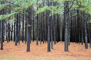
A tree plantation, forest plantation, plantation forest, timber plantation or tree farm is a forest planted for high volume production of wood, usually by planting one type of tree as a monoculture forest. The term tree farm also is used to refer to tree nurseries and Christmas tree farms.
