Stockstadt am Main

Last updated
Stockstadt a.Main
Stockstadt am Main Aerial fg155.jpg
Aerial view of the town
Wappen Stockstadt am Main.svg
Location of Stockstadt a.Main within Aschaffenburg district
Stockstadt am Main in AB.svgJohannesbergWiesener ForstForst Hain im SpessartHeinrichsthaler ForstHeinrichsthaler ForstWaldaschaffer ForstSchöllkrippener ForstSailaufer ForstRohrbrunner ForstRothenbucher ForstGoldbachWiesenKrombachHaibach
Germany adm location map.svg
Red pog.svg
Stockstadt a.Main
Bavaria location map.svg
Red pog.svg
Stockstadt a.Main
Coordinates: 49°58′47″N09°03′50″E / 49.97972°N 9.06389°E / 49.97972; 9.06389
Country Germany
State Bavaria
Admin. region Unterfranken
District Aschaffenburg
Government
   Mayor (202026) Rafael Herbrik [1] (SPD)
Area
  Total18.86 km2 (7.28 sq mi)
Elevation
117 m (384 ft)
Population
 (2022-12-31) [2]
  Total8,061
  Density430/km2 (1,100/sq mi)
Time zone UTC+01:00 (CET)
  Summer (DST) UTC+02:00 (CEST)
Postal codes
63809-63811
Dialling codes 06027
Vehicle registration AB
Website www.stockstadt-am-main.de
Constituent communities Markt Stockstadt am Main.png
Constituent communities

Stockstadt am Main (officially: Stockstadt a.Main) is a market community in the Aschaffenburg district in the Regierungsbezirk of Lower Franconia (Unterfranken) in Bavaria, Germany.

Contents

The settlement was established by the Romans who built a fort here in the 1st century AD. Stockstadt has a population of around 8,000 (2020).

Geography

Location

Stockstadt am Main lies on Aschaffenburg’s western town limit on the Main’s left bank. To Stockstadt’s west and northwest runs the boundary with Hesse, and southwest of Stockstadt lies the Bachgau.

Neighbouring communities

To the south is the community of Großostheim, and to the southwest, beyond the state boundary, in Hesse, lies Babenhausen; northwest lie Mainhausen and Seligenstadt.

The nearest neighbouring communities are Kleinostheim to the north and Mainaschaff to the east.

Stockstadt am Main Stockstadt am Main, Hauptstrasse 44, 001.jpg
Stockstadt am Main

History

The Romans built a castrum at Stockstadt, as part of the Limes Germanicus. In the 1st century AD a small earthen fortification was erected. Around the year 100 it was replaced by a full cohort fort further to the southeast. This castrum had a size of 3.2 ha. Over time, it was occupied by the cohorts III Aquitanorum, II Hispanorum and I Aquitanorum. Stockstadt was also the site of a "de:Benefiziarer station" (i.e. a road house). [3] :30

After the withdrawal of the Romans from the area, the regional population declined. Burgundians and Alemanni moved through the lower Main region, but it was only under the Franks (after 500 AD) that the population density again rose noticeably. Their settlements often did not simply grow out of the formerly Roman cores but included separate newly established sites. [3] :30,66–7

At Stockstadt, a Frankish graveyard was discovered to the northwest of the Roman structures. The Frankish settlement was likely located nearby, on the right bank of the Gersprenz, north of the former Roman structures. The initial parish church and graveyard were located not in this area but around 700 meters to the southeast, at the location of the former castrum. It is likely that a separate settlement was still in existence then at this site and it may even have been more important than the other site. The parish church was dedicated to the saints Marcellinus and Peter, the patrons of Seligenstadt Abbey, to which Stockstadt temporarily belonged. It is unclear, whether this settlement was later abandoned or moved to the northwest. Later during the Middle Ages, the settlement between Gersprenz and Main was fortified by a wall with towers and moat. The church initially remained at the southeasterly location, however. At the site of the current church, the Leonhardskirche, remains of an earlier structure only date from the Gothic period. [3] :65–6

Stockstadt am Main had its first documentary mention as early as the 9th century, if only through some townsmen who were obliged to pay taxes. These are listed as living in Stocestat, as the community was known then.

Eventually the community itself was named in writing for the first time in 1024. Stoddenstat was donated to Fulda Abbey by Henry II, Holy Roman Emperor. This lasted until 1309, when Stockstadt was given to the Archbishopric of Mainz.

In the Middle Ages the surrounding forests belonged to the Dreieich Royal Hunting Forest ( Wildbann Dreieich), which also had one of its 30 Wildhuben (farming estates whose owners were charged with guarding the king's hunting rights) in Stockstadt.

Governance

Community council

The council is made up of 21 council members, counting the full-time mayor.

CSU SPD Freie Wählergemeinschaft Total
2002710+1(mayor)321 seats
200810+1(mayor)7321 seats

(as at municipal election held on 2 March 2008)

Elections in 2014: [4] [ circular reference ]

Town partnerships

Coat of arms

The community's arms might be described thus: Azure a fess wavy abased argent above which a legionnaire's helmet of the second crested gules in profile.

Attractions

St. Anna-Kapelle Stockstadt Kapelle.jpg
St. Anna-Kapelle

Related Research Articles

Offenbach is a Kreis (district) in the south of Hesse, Germany and is part of the Frankfurt/Rhine-Main Metropolitan Region. Neighbouring districts are Main-Kinzig, Aschaffenburg, Darmstadt-Dieburg, Groß-Gerau and the cities of Darmstadt, Frankfurt and Offenbach.

Aschaffenburg is a Landkreis (district) in Bavaria, Germany. It is bounded by the districts of Darmstadt-Dieburg, Offenbach, Main-Kinzig, the districts Main-Spessart and Miltenberg, and the town of Aschaffenburg.

<span class="mw-page-title-main">Rödermark</span> Town in Hesse, Germany

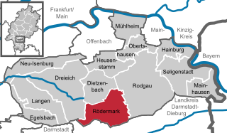
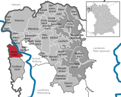
Rödermark is a town in the Offenbach district in the Regierungsbezirk of Darmstadt in Hesse, Germany, southeast of Frankfurt am Main and northeast of Darmstadt.

<span class="mw-page-title-main">Karlstein am Main</span> Municipality in Bavaria, Germany

Karlstein am Main is a municipality in the Aschaffenburg district in the Regierungsbezirk of Lower Franconia (Unterfranken) in Bavaria, Germany. It is the westernmost settlement in Bavaria. Karlstein's Ortsteile are Dettingen and Großwelzheim, the former being notable as the site of the Battle of Dettingen during the War of the Austrian Succession. In the 20th century, the town was the site of the, now decommissioned, Großwelzheim Nuclear Power Plant.

<span class="mw-page-title-main">Rodgau</span> Town in Hesse, Germany

Rodgau is a town in the Offenbach district in the Regierungsbezirk of Darmstadt in Hesse, Germany. It lies southeast of Frankfurt am Main in the Frankfurt Rhine Main Region and has the greatest population of any municipality in the Offenbach district. It came into being in 1979 when the greater community of Rodgau was raised to town, after having been formed through a merger of five formerly self-administering communities in the framework of municipal reform in Hesse in 1977. The current constituent communities’ history reaches back to the 8th century.

<span class="mw-page-title-main">Michelstadt</span> Town in Hesse, Germany

Michelstadt in the Odenwald is a town in the Odenwaldkreis (district) in southern Hesse, Germany between Darmstadt and Heidelberg. It has a population of 28,629 people.

<span class="mw-page-title-main">Hainburg, Germany</span> Municipality in Hesse, Germany

Hainburg is a municipality of just under 14,400 inhabitants in the Offenbach district in the Regierungsbezirk of Darmstadt in Hesse, Germany.

<span class="mw-page-title-main">Seligenstadt</span> Town in Hesse, Germany

Seligenstadt is a town in the Offenbach district in the Regierungsbezirk of Darmstadt in Hesse, Germany. Seligenstadt is one of Germany's oldest towns and was already of great importance in Carolingian times.

<span class="mw-page-title-main">Alzenau</span> Town in Bavaria, Germany

Alzenau is a town in the north of the Aschaffenburg district in the Regierungsbezirk of Lower Franconia (Unterfranken) in Bavaria, Germany. Until 1 July 1972, Alzenau was the district seat of the now abolished district of the same name and has a population of around 19,000.

<span class="mw-page-title-main">Goldbach, Bavaria</span> Municipality in Bavaria, Germany

Goldbach is a market community in the Aschaffenburg district in the Regierungsbezirk of Lower Franconia (Unterfranken) in Bavaria, Germany.

<span class="mw-page-title-main">Gernsheim</span> Town in Hesse, Germany

Gernsheim is a town in Groß-Gerau district and Darmstadt region in Hesse, Germany, lying on the Rhine.

<span class="mw-page-title-main">Mömlingen</span> Municipality in Bavaria, Germany

Mömlingen is a municipality in the Miltenberg district in the Regierungsbezirk of Lower Franconia (Unterfranken) in Bavaria, Germany.

<span class="mw-page-title-main">Obernburg</span> Town in Bavaria, Germany

Obernburg am Main is a town in the Miltenberg district in the Regierungsbezirk of Lower Franconia (Unterfranken) in Bavaria, Germany. It has a population of around 8,500.

<span class="mw-page-title-main">Wörth am Main</span> Town in Bavaria, Germany

Wörth am Main is a town in the Miltenberg district in the Regierungsbezirk of Lower Franconia (Unterfranken) in Bavaria, Germany. It has a population of around 4,700.

<span class="mw-page-title-main">Geiselbach</span> Municipality in Bavaria, Germany

Geiselbach is a community in the Aschaffenburg district in the Regierungsbezirk of Lower Franconia (Unterfranken) in Bavaria, Germany.

<span class="mw-page-title-main">Johannesberg, Bavaria</span> Municipality in Bavaria, Germany

Johannesberg is a community in the Aschaffenburg district in the Regierungsbezirk of Lower Franconia (Unterfranken) in Bavaria, Germany. It has around 3,900 inhabitants.

<span class="mw-page-title-main">Mainhausen</span> Municipality in Hesse, Germany

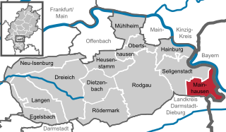
Mainhausen is a municipality of over 9,000 in the Offenbach district in the Regierungsbezirk of Darmstadt in Hesse, Germany.

The Rhine-Main Railway, is a railway line in southern Germany from Mainz via Darmstadt to Aschaffenburg. It was built by the Hessian Ludwig Railway and opened on 1 August 1858 and is one of the oldest railways in Germany. Until 1862, when the railway bridge over the Rhine river constructed and assembled by MAN-Werk Gustavsburg was finished, a train ferry operated on the river.

The Main Limes, also called the Nasser Limes, was built around 90 AD and, as part of the Upper Germanic-Rhaetian Limes, formed the frontier of the Roman Empire in the area between the present day villages of Großkrotzenburg and Bürgstadt. In this section the limes adjoined the River Main (Moenus), which forms a natural boundary for about 50 kilometres here, so "Main" refers to the river.

Stockstadt Fort is a former Roman fort located in Stockstadt am Main in the district of Aschaffenburg in Lower Franconia. Following several years of excavations, mainly in the early 20th century, evidence was uncovered indicating the existence of a fort complex comprising two previously documented predecessor buildings, as well as a succession of different troops stationed there. From the early period of the Upper Germanic-Raetian Limes to the fall of the Limes, Stockstadt was therefore an important military camp on the Main Limes, the so-called Wet Limes. The site is of significant archaeological interest due to the large number of stone monuments that have been discovered, particularly in the vicus area, which encompasses two mithrae, a Jupiter Dolichenus sanctuary and a beneficiarius station.

References

  1. Liste der ersten Bürgermeister/Oberbürgermeister in kreisangehörigen Gemeinden, Bayerisches Landesamt für Statistik, 15 July 2021.
  2. Genesis Online-Datenbank des Bayerischen Landesamtes für Statistik Tabelle 12411-003r Fortschreibung des Bevölkerungsstandes: Gemeinden, Stichtag (Einwohnerzahlen auf Grundlage des Zensus 2011) (Hilfe dazu).
  3. 1 2 3 4 5 Römisch-Germanisches Zentralmuseum Mainz (ed.) (1974). Führer zu den vor- und frühgeschichtlichen Denkmälern, Band 8. Verlag Philipp von Zabern.{{cite book}}: |last= has generic name (help)
  4. de:Stockstadt am Main#Marktgemeinderat