Related Research Articles

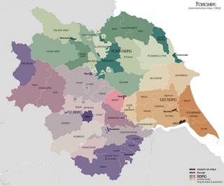
The North Riding of Yorkshire was a subdivision of Yorkshire, England, alongside York, the East Riding and West Riding. The riding's highest point was at Mickle Fell at 2,585 ft (788 m).

Hambleton was a local government district in North Yorkshire, England. The administrative centre was Northallerton, and the district included the outlying towns and villages of Bedale, Thirsk, Great Ayton, Stokesley, and Easingwold.

The Borough of Stockton-on-Tees is a unitary authority area in England with borough status in County Durham and North Yorkshire. In 2021, it had a population of 196,600. Its main settlement and namesake of the borough is Stockton-on-Tees, which lies on the north bank of the River Tees, along with the towns of Billingham and Norton-on-Tees, in County Durham. It also includes the towns of Ingleby Barwick, Thornaby-on-Tees and Yarm, all south of the Tees, in North Yorkshire. The borough locally governed by Stockton-on-Tees Borough Council. The borough forms part of the Tees Valley together with four other nearby boroughs.

Tees Valley is a combined authority area in North East England, around the lower River Tees. The area is not a geographical valley; the local term for the valley is Teesdale. The combined authority covers five council areas: Darlington, Hartlepool, Middlesbrough, Redcar and Cleveland and Stockton-on-Tees.
Sedbergh Rural District was a rural district in the West Riding of Yorkshire in England from 1894 to its abolition in 1974. The district consisted of the three parishes of Sedbergh, Garsdale and Dent. In 1974 the district became part of the South Lakeland district in the new non-metropolitan county of Cumbria.

Wetherby was a rural district in the West Riding of Yorkshire from 1894 to 1974. It was named after the town of Wetherby.

Stokesley is a market town and civil parish in North Yorkshire, England. It lies within the historic county boundaries of the North Riding of Yorkshire, on the River Leven. An electoral ward of the same name stretches south to Great Broughton and had a population at the 2021 Census of 6,180.
Selby was a rural district in the West Riding of Yorkshire from 1894 to 1974.
Croft was a rural district in the North Riding of Yorkshire from 1894 to 1974.
High Leven is a village of Ingleby Barwick in North Yorkshire, England. It is in the borough of Stockton-on-Tees, on top of the River Leven's dell. It has a public house called The Fox Covert and a co-operative food store, open every day 05:00 to 24:00, with an ATM and petrol station.

Middlesbrough Council, formerly Middlesbrough Borough Council, is the unitary authority covering the Borough of Middlesbrough, North Yorkshire, England. Following the 2023 local elections, Labour has held majority control of the council, which meets at the Town Hall. It is led by the directly-elected Mayor of Middlesbrough. The council is a member of the Tees Valley Combined Authority.

Greater Eston is part of the Borough of Redcar and Cleveland, North Yorkshire, England. The name is used by the borough council to describe the centres of Eston, Grangetown, Normanby, Ormesby, South Bank and Teesville.
Langbaurgh West was a division of the wapentake of Langbaurgh in the North Riding of the ancient county of Yorkshire. The area along with Langbaurgh East forms the Anglo-Saxon baronial Liberty of Cleveland and roughly covers the modern districts of Middlesbrough, the western, urbanised portion of Redcar & Cleveland, the southern portion of Stockton-on-Tees, the northern parts of Hambleton and the northern parts of the Borough of Scarborough.
Middlesbrough Rural District was a rural district in the North Riding of Yorkshire, England from 1894 to 1932.

Cleveland was a non-metropolitan county located in North East England which existed between 1974 and 1996. Cleveland was a two-tier county and had four boroughs: Hartlepool, Stockton-on-Tees, Middlesbrough and Langbaurgh-on-Tees. The county town was Middlesbrough, where Cleveland County Council met. The county was named after the historic area of Cleveland, Yorkshire. Its area is now split between the counties of North Yorkshire and County Durham.
The East Riding of Yorkshire is a local government district with unitary authority status, and is a ceremonial county of England. It is named after the historic East Riding of Yorkshire which was one of three ridings alongside the North Riding and West Riding, which were constituent parts a Yorkshire ceremonial and administrative county until 1974. From 1974 to 1996 the area of the modern East Riding of Yorkshire constituted the northern part of Humberside.

The County Borough of Teesside was a county borough in the north-east of England, which existed for just six years. It was created in 1968 to cover the Teesside conurbation which had grown up around the various port and industrial towns near the mouth of the River Tees. The council was based in Middlesbrough, the area's largest town. The county borough was abolished in 1974 on the creation of the new county of Cleveland, which covered a larger area, with the county borough's territory being split between three of the four districts created in the new county.
Settle Rural District was an administrative district in the West Riding of Yorkshire, England. The rural district was named after the town of Settle and included the civil parishes of Bentham, Clapham cum Newby, Malham, Settle, Stainforth, Austwick, Giggleswick, Ingleton and Horton.
Trenholme Bar railway station was a railway station built to serve the hamlet of Trenholme Bar in North Yorkshire, England. The station was on the North Yorkshire and Cleveland's railway line between Picton and Stokesley, which opened in 1857. The line was extended progressively until it met the Whitby & Pickering Railway at Grosmont. Trenholme Bar station was closed in 1954 to passengers and four years later to goods. The station was located 9 miles (14 km) south of Stockton, and 10 miles (16 km) west of Battersby railway station.
The non-metropolitan county of Cleveland was created under the Local Government Act 1972, which came into effect on 1 April 1974, comprising the urban areas around the mouth of the River Tees, previously parts of the administrative counties of Durham and North Riding of Yorkshire. Cleveland was abolished in 1996 both as a county council and a non-metropolitan county, being succeeded by the unitary authorities of Hartlepool, Middlesbrough, Redcar and Cleveland, and Stockton-on-Tees. The constituency boundaries used up to the 2005 United Kingdom general election were drawn up when the county still existed. For the review which came into effect for the 2010 general election, the four authorities were considered separately, with Middlesbrough and Redcar and Cleveland being combined.
References
- ↑ "Stokesley RD through time | Census tables with data for the Local Government District". visionofbritain.org.uk. Retrieved 24 September 2020.
- ↑ "Stokesley RD North Riding through time | Administrative history of Local Government District: hierarchies, boundaries". visionofbritain.org.uk. 1 October 2007. Archived from the original on 1 October 2007. Retrieved 24 September 2020.
54°28′16″N1°11′28″W / 54.471°N 1.191°W
| | This Hambleton, North Yorkshire location article is a stub. You can help Wikipedia by expanding it. |