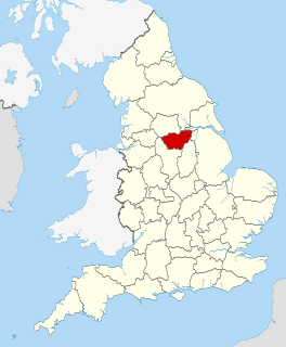
South Yorkshire is a ceremonial and metropolitan county in England. It is the southernmost county in the Yorkshire and the Humber region and had a population of 1.34 million in 2011. It has an area of 1,552 square kilometres (599 sq mi) and consists of four metropolitan boroughs, Barnsley, Doncaster, Rotherham and Sheffield. South Yorkshire was created on 1 April 1974 as a result of the Local Government Act 1972. Its largest settlement is Sheffield.

The River Don is a river in South Yorkshire and the East Riding of Yorkshire, England. It rises in the Pennines, west of Dunford Bridge, and flows for 70 miles (113 km) eastwards, through the Don Valley, via Penistone, Sheffield, Rotherham, Mexborough, Conisbrough, Doncaster and Stainforth. It originally joined the Trent, but was re-engineered by Cornelius Vermuyden as the Dutch River in the 1620s, and now joins the River Ouse at Goole. Don Valley is a UK parliamentary constituency near the Doncaster stretch of the river.

The Metropolitan Borough of Rotherham is a metropolitan borough of South Yorkshire, England. It is named after its largest town, Rotherham, but also spans the outlying towns of Maltby, Swinton, Wath-upon-Dearne, Dinnington and also the villages of Rawmarsh and Laughton. A large valley also spans the entire borough. Locally known as the Rother Valley.

Maltby is a former mining town and civil parish of 16,688 inhabitants (2011) in the Metropolitan Borough of Rotherham, South Yorkshire, England. It was historically in the West Riding of Yorkshire. It is located about 6 miles (10 km) east of Rotherham town centre and 10 miles (16 km) north-east of Sheffield city centre. It forms a continuous urban area with Hellaby, separated from the rest of Rotherham by the M18 motorway.

Mexborough is a town in the Metropolitan Borough of Doncaster in South Yorkshire, England. Situated between Manvers and Denaby Main, it lies on the River Don close to where it joins the River Dearne, and the A6023 road runs through the town. It is contiguous with the town of Swinton which is directly to the southwest immediately across the railway and Conisbrough to the east.

South Yorkshire Police (SYP) is the territorial police force responsible for policing South Yorkshire in England. The force is led by Chief Constable Lauren Poultney. Oversight is conducted by Police and Crime Commissioner Alan Billings.

The Blackburn Brook is a stream in Sheffield, South Yorkshire, England which flows through the Blackburn Valley along the M1 and Ecclesfield Road and joins the River Don near the Meadowhall shopping centre. Downstream from the A61 road at Chapeltown the Blackburn Brook is defined as a main river by the Environment Agency, which requires new building development to be at least 26 feet (8 m) from the bank side as a flood defence measure and to allow access to the watercourse for maintenance.
Crowden is a hamlet in the High Peak borough of Derbyshire, England. Historically a part of Cheshire, Crowden was incorporated into Derbyshire for administrative and ceremonial purposes in 1974 and is now Derbyshire's most northerly settlement. It lies in the Longdendale valley, 5.8 miles (9.3 km) north-east of Glossop and 5.7 miles (9.2 km) south-west of Holme in West Yorkshire.

The Maltby Main Colliery was a coal mine located 7 miles (11 km) east of Rotherham on the eastern edge of Maltby, South Yorkshire, England. The mine was closed in 2013.

Ulley is a village and civil parish of the Metropolitan Borough of Rotherham in South Yorkshire, England. The population of the civil parish as of the 2011 census was 172. It is located about 4 miles (6 km) south of the town of Rotherham and 7 miles (11 km) east of Sheffield City Centre.

While there are many castles in South Yorkshire, the majority are manor houses and motte-and-bailey which were commonly found in England after the Norman Conquest.

Rotherham is a large market and minster town in South Yorkshire, England. The town takes its name from the River Rother which then merges with the River Don. The River Don then flows through the town centre. It is the main settlement of the Metropolitan Borough of Rotherham. Rotherham is also the third largest settlement in South Yorkshire after Sheffield and Doncaster, which it is located between.

Bramley is a village and civil parish of the Metropolitan Borough of Rotherham in South Yorkshire, England.

Maltby Academy is an academy school in the mining town of Maltby in South Yorkshire, England.

The New York Stadium is a football stadium in Rotherham, South Yorkshire, England. Opened in July 2012, it is the home ground of Rotherham United.

Sandbeck Park is a Neo-Palladian country house in Maltby, South Yorkshire, England. The house dates to the 17th century and was extensively expanded and remodeled in the 18th and 19th centuries. The house is Grade I listed with Historic England and several outbuildings on the estate are also listed. The house has been the seat of the Earls of Scarbrough since the 18th century. The garden was designed by Lancelot Brown and is also Grade II* listed.

Oldcotes Dyke is the name of the final section of a river system that drains parts of north Nottinghamshire and the Metropolitan Borough of Rotherham in South Yorkshire, England. Historically, it has supported milling, with seven water mills drawing their power from its water, and ran through the grounds of the Cistercian Roche Abbey. It is a tributary of the River Ryton.

Harley is a hamlet in the civil parish of Wentworth, in the Rotherham district lying to the north of Rotherham and Sheffield, South Yorkshire, England.
Maltby is a civil parish in the Metropolitan Borough of Rotherham, South Yorkshire, England. The parish contains 40 listed buildings that are recorded in the National Heritage List for England. Of these, one is listed at Grade I, the highest of the three grades, three are at Grade II*, the middle grade, and the others are at Grade II, the lowest grade. The parish contains the town of Maltby and a large area to the southeast of the town. This area includes the country house of Sandbeck Park, which is listed together with a number of associated buildings and structures. Also in the area is Roche Abbey, and items in its grounds are listed. The other listed buildings include houses and cottages, a church and a tomb in the churchyard, a market cross, former watermills, farmhouses and farm buildings, mileposts, and a war memorial.

