
Manassas, formerly Manassas Junction, is an independent city in the Commonwealth of Virginia, United States. The population was 42,772 at the 2020 Census. It is the county seat of Prince William County, although the two are separate jurisdictions. Manassas borders the independent city of Manassas Park, Virginia. The Bureau of Economic Analysis includes both Manassas and Manassas Park with Prince William County for statistical purposes.

The First Battle of Bull Run, called the Battle of First Manassas by Confederate forces, was the first major battle of the American Civil War. The battle was fought on July 21, 1861, in Prince William County, Virginia, just north of what is now the city of Manassas and about thirty miles west-southwest of Washington, D.C. The Union Army was slow in positioning themselves, allowing Confederate reinforcements time to arrive by rail. Each side had about 18,000 poorly trained and poorly led troops. The battle was a Confederate victory and was followed by a disorganized post-battle retreat of the Union forces.
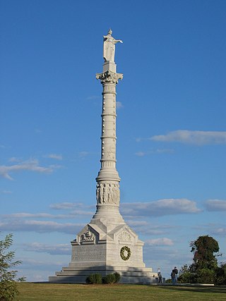
Colonial National Historical Park is a large national historical park located in the Hampton Roads region of Virginia operated by the National Park Service. It protects and interprets several sites relating to the Colony of Virginia and the history of the United States more broadly. These range from the site of the first English settlement at Jamestown, to the battlefields of Yorktown where the British Army was defeated in the American Revolutionary War. Over 3 million people visit the park each year.

The Orange and Alexandria Railroad (O&A) was a railroad in Virginia, United States. Chartered in 1848, it eventually extended from Alexandria to Gordonsville, with another section from Charlottesville to Lynchburg. The road played a crucial role in the American Civil War, saw the first of many mergers in 1867, and eventually became an important part of the modern-day Norfolk Southern rail system.

The First Battle of Rappahannock Station, as took place on August 23, 1862, at present-day Remington, Virginia, as part of the Northern Virginia Campaign of the American Civil War.

Colonial Parkway is a 23-mile (37 km) scenic parkway linking the three points of Virginia's Historic Triangle, Jamestown, Williamsburg, and Yorktown. It is part of the National Park Service's Colonial National Historical Park. Virginia's official state classification for the parkway is State Route 90003. With portions built between 1930 and 1957, it links the three communities via a roadway shielded from views of commercial development. The roadway is toll-free, is free of semi trucks, and has speed limits of around 35 to 45 mph. As a National Scenic Byway and All-American Road, it is also popular with tourists due to the James River and York River ends of the parkway.

State Route 193 is a primary state highway in the U.S. state of Virginia. Known as Georgetown Pike, the state highway runs 11.79 mi (18.97 km) from SR 7 in Dranesville east to SR 123 in Langley. SR 193 passes through Great Falls and meets Interstate 495 (I-495) in McLean. The state highway was designated the first Virginia Byway for its scenic value in 1974.

Manassas National Battlefield Park is a unit of the National Park Service located in Prince William County, Virginia, north of Manassas that preserves the site of two major American Civil War battles: the First Battle of Bull Run, also called the Battle of First Manassas, and the Second Battle of Bull Run or Battle of Second Manassas. It was also where Confederate General Thomas J. Jackson acquired his nickname "Stonewall". The park was established in 1936 and listed on the National Register of Historic Places on October 15, 1966.

State Route 28 in the U.S. state of Virginia is a primary state highway that traverses the counties of Loudoun, Fairfax, Prince William, and Fauquier in the U.S. state of Virginia. The route serves as a major artery in the Northern Virginia region, with it being an important two-lane highway in rural Fauquier and Prince William Counties, the main thoroughfare through Manassas and Manassas Park, and a high-capacity freeway through Fairfax and Loudoun Counties.

Goose Creek is a 53.9-mile-long (86.7 km) tributary of the Potomac River in Fauquier and Loudoun counties in northern Virginia. It comprises the principal drainage system for the Loudoun Valley.

Henry House Hill is a location near Bull Run in Virginia. Named for the house of the Henry family that sits atop it, the hill begins near the road of Centreville, Virginia, after Gainesville, Virginia, to today's U.S. Route 29, the Warrenton Turnpike. It is a slow, constant rise toward the south over a length of approximately 730 meters. This hill was an important site of the battles of First and Second Bull Run in the American Civil War. The battle raged on the north side of the hill in predominantly open grass country; the south side was relatively closely covered with trees. The hill received its name from Dr. Isaac Henry, who lived with his family in a house on the plateau of the hill. On July 21, 1861, the house was inhabited by his widow, Judith Carter Henry, and their two sons. The 85-year-old woman was bed-ridden and unable to leave the house. Mrs. Henry was mortally wounded when a projectile of the Union artillery crashed through the bedroom wall and tore off one of her feet and inflicted multiple injuries, from which she died later that day.

The Middlefield–Becket Stone Arch Railroad Bridge District is a historic district extending through parts of the towns of Chester, Middlefield, and Becket, Massachusetts. The district encompasses a 3.7-mile (6.0 km) stretch of railroad right of way in which there are ten bridge crossings, including nine over the west branch of the Westfield River. The bridges were built in four time periods: 1840, 1866, 1912, and 1928. Nine of the ten bridges are stone or concrete masonry work, and one is a truss girder bridge. All are, with only minor exceptions, in excellent and original condition. The bridges were built to carry the Western Railroad through on its run from the Connecticut River to the Hudson River. This section of railroad was the most expensive the company had to build, costing over $1 million in 1840.

Cartersville Bridge is a historic bridge located near Cartersville, Cumberland County, Virginia. The original bridge was constructed in 1822, and its five stone piers of rough cut ashlar and rubble and two stone abutments remain. Atop them is a superstructure constructed in 1883-84 of heavy timber members with cast-iron connections arranged to form a truss configuration based on the Pratt truss. The bridge is composed of six spans with an end-to-end length of 843 feet (257 m).

The Bull Run campaign, also known as the Manassas campaign, was a series of military engagements in the Eastern Theater of the American Civil War in 1861.

Valley Railroad Stone Bridge is a historic stone arch bridge spanning Folly Mills Creek near Jolivue, Augusta County, Virginia. It was built in 1874 by the Valley Railroad, and is a four-span structure with an overall length of 130 feet (40 m) and a width of 15 feet (4.6 m). It is constructed of granite and faced in ashlar and features semi-circular arches set on gently splayed piers. It was acquired by the Virginia Department of Transportation in 1965. It is considered a scenic landmark along Interstate 81.

Delaplane Historic District is a national historic district located at Delaplane, Fauquier County, Virginia.

Bowstring Truss Bridge, also known as the Roaring Run Bowstring Truss Bridge and King Tubular Arch Truss Bridge, is a historic bowstring truss bridge located at the Ironto Rest Area near Ironto, Montgomery County, Virginia. It was built by the King Bridge Company in 1878, and is a single-span, four-panel tubular arch pony truss. It measures 55 feet (17 m) long, 12 feet (3.7 m) wide, and 6 feet 6 inches (1.98 m) high with an open roadway width of approximately 9 feet 6 inches (2.90 m). The bridge was partially disassembled and moved from its original location to a second site during the 1930s, where it remained until moved to its current location in 1977.

Evergreen, also known as Evergreen Plantation Manor House, is a historic plantation house located near Haymarket, Prince William County, Virginia. It is known for its association with Edmund Berkeley (1824-1915), one of four brothers who led the 8th Virginia Infantry during the American Civil War and who later became a local philanthropist and led many veterans' peace and commemorative activities.
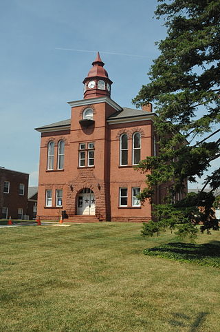
Prince William County Courthouse is a historic courthouse located at 9248 Lee Avenue, Manassas, Prince William County, Virginia. Rehabilitated in 2000–2001, it currently houses some offices of the Prince William County clerk, and the historic courtroom upstairs can be rented for events.

Ben Lomond, also known as Ben Lomond Plantation, is a historic plantation house located at Bull Run, Prince William County, Virginia. It was built in 1837, and is a two-story, five-bay, red sandstone dwelling with a gable roof. The house has a central-hall plan and one-story frame kitchen addition. One-story pedimented porches shelter the main (north) and rear (south) entries. Also on the property are the contributing frame two-story tenant's house, brick pumphouse, and a bunkhouse dated to the early 20th century; and a meat house, dairy, and slave quarters dated to the late-1830s.


