
Garden of the Gods is a 1,341.3 acre public park located in Colorado Springs, Colorado, United States. 862 acres of the park was designated a National Natural Landmark in 1971.

The Rock of Gibraltar is a monolithic limestone mountain 426 m (1,398 ft) high dominating the western entrance to the Mediterranean Sea. It is situated near the end of a narrow 9 kilometres (5.6 mi) long promontory stretching due south into the Mediterranean Sea and is located within the British territory of Gibraltar, and is 27 km north-east of Tarifa, Spain, the southwestern tip of Europe on the Iberian Peninsula. The rock serves as an impregnable fortress and contains a labyrinthine network of man-made tunnels known as the Tunnels of Gibraltar. Most of the Rock's upper area comprises a nature reserve which is home to about 300 Barbary macaques. It is a major tourist attraction.

Old Harry Rocks are three chalk formations, including a stack and a stump, located at Handfast Point, on the Isle of Purbeck in Dorset, southern England. They mark the most eastern point of the Jurassic Coast, a UNESCO World Heritage Site.

The Ring of Gullion is a geological formation and area, officially designated as an Area of Outstanding Natural Beauty, (AONB) located in County Armagh, Northern Ireland. The area centres on Slieve Gullion, the highest peak in County Armagh, measures roughly 42 by 18 kilometres and comprises some 150 km2 defined topographically by the hills of an ancient ring dyke. Parts of the area have also been officially listed as Areas of Special Scientific Interest.

Kratovo is a small town in North Macedonia. It is the seat of Kratovo Municipality. It lies on the western slopes of Mount Osogovo at an altitude of 600 metres (2,000 ft) above sea level. Having a mild and pleasant climate, it is located in the crater of an extinct volcano. It is known for its bridges and towers.

Carboniferous Limestone is a collective term for the succession of limestones occurring widely throughout Great Britain and Ireland that were deposited during the Dinantian Epoch of the Carboniferous Period. These rocks formed between 363 and 325 million years ago. Within England and Wales, the entire limestone succession, which includes subordinate mudstones and some thin sandstones, is known as the Carboniferous Limestone Supergroup.

Chitradurga is a city and the headquarters of Chitradurga district, which is located on the valley of the Vedavati river in the central part of the Indian state of Karnataka. Chitradurga is a place with historical significance and a major tourist hub of Karnataka. The city is renowned for its 15th century Kallina Kote or Stone Fortress. This is formed of two Kannada words: ‘Kallina’ means "Stone's" and Kote means "Fort". Other names used in Kannada are ‘Ukkina Kote": "Steel Fort" and ‘Yelusuttina Kote’: "Seven Circles Fort".
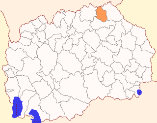
Rankovce is a municipality in the northeastern region of the Republic of North Macedonia. Rankovce is also the name of the town where the municipal seat is found. Rankovce Municipality is part of the Northeastern statistical region.

The Seven Stones reef is a rocky reef nearly 15 miles (24 km) west of Land's End, Cornwall and 7 miles (11 km) east-northeast of the Isles of Scilly. The reef consists of two groups of rocks and is nearly 2 miles (3.2 km) long and 1 mile (1.6 km) in breadth. They rise out of deep water and are a navigational hazard for shipping with 71 named wrecks and an estimated 200 shipwrecks overall. The most infamous is the Torrey Canyon in 1967, which was at that time the world's costliest shipping disaster and, to date, still the worst oil spill on the coast of the United Kingdom.

The Cheesewring is a granite tor in Cornwall, England, situated on the eastern flank of Bodmin Moor on Stowe's Hill in the parish of Linkinhorne approximately one mile northwest of the village of Minions and four miles (6 km) north of Liskeard. It is a natural geological formation, a rock outcrop of granite slabs formed by weathering. The name derives from the resemblance of the piled slabs to a stack of "cheeses" in a traditional cider press.
Đavolja varoš is a rock formation consisting of about 200 earth pyramids or "towers", located in southern Serbia on the Radan Mountain, in the municipality of Kuršumlija. There are several similar geological formations in the world, but Đavolja Varoš has the most numerous and the tallest "towers".

Robert Sibley Volcanic Regional Preserve is located in the Oakland Hills of the East Bay region of the San Francisco Bay Area, California. The park is part of the East Bay Regional Parks District (EBRPD), covers 928 acres (3.76 km2), and lies east of Oakland, partly in Alameda County and partly in Contra Costa County. It can be entered from Oakland via Skyline Boulevard, or from Contra Costa County via Old Tunnel Road.

The Stone Forest or Shilin is a notable set of limestone formations about 500 km2 located in Shilin Yi Autonomous County, Yunnan Province, People's Republic of China, near Shilin approximately 90 km (56 mi) from the provincial capital Kunming.

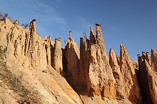
Kuklica is a small village in the municipality of Kratovo, North Macedonia. It is known for the hundreds of naturally formed stone pillars that resemble humans. The village has about 100 inhabitants.

Tourism in North Macedonia is a large factor of the nation's economy. The country's large abundance of natural and cultural attractions make it suitable for tourism.
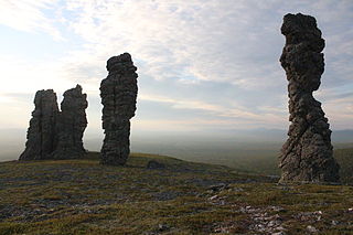
The Manpupuner rock formations are a set of 7 stone pillars located west of the Ural Mountains in the Troitsko-Pechorsky District of the Komi Republic. They are located on the territory of the Pechoro-Ilychski Reserve on the mountain Man-Pupu-nyor, between the Ilych and Pechora rivers. They are also known as the Seven Strong Men Rock Formations and the Poles of the Komi Republic. Deemed one of the Seven Wonders of Russia, the Manpupuner rock formations are a popular attraction in Russia, though relatively unspoiled by tourism.
The geology of the Isle of Man consists primarily of a thick pile of sedimentary rocks dating from the Ordovician period, together with smaller areas of later sedimentary and extrusive igneous strata. The older strata was folded and faulted during the Caledonian and Acadian orogenies The bedrock is overlain by a range of glacial and post-glacial deposits. Igneous intrusions in the form of dykes and plutons are common, some associated with mineralisation which spawned a minor metal mining industry.

The geology of North Macedonia includes the study of rocks dating to the Precambrian and a wide array of volcanic, sedimentary and metamorphic rocks formed in the last 539 million years.

Lesnovo Volcanic Cone is a volcanic cone in the western part of Osogovo Mountains, between the town of Probištip and the village of Zletovo. It is one of the best preserved volcanic cones in the Kratovo-Zletovo volcanic area as well as in all of North Macedonia. The cone is named after the village of Lesnovo, which is located in the crater of the cone's summit, also known as Lesnovo Crater. The village is the only settlement in North Macedonia that lies in a clearly preserved fossil volcanic crater. Serbian geographer Jovan Cvijić compared Lesnovo Crater to the crater Valle del Bove located on Mount Etna. Because it is one of the most preserved and most notable craters in North Macedonia, Lesnovo Crater was declared a natural landmark and finds itself on the National Conservation Centre's list of geological rarities.


