
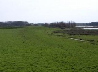
The Fens or Fenlands in eastern England are a naturally marshy region supporting a rich ecology and numerous species. Most of the fens were drained centuries ago, resulting in a flat, dry, low-lying agricultural region supported by a system of drainage channels and man-made rivers and automated pumping stations. There have been unintended consequences to this reclamation, as the land level has continued to sink and the dykes have been built higher to protect it from flooding.

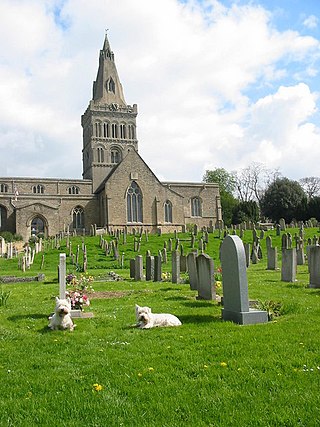
Soham is a town and civil parish in the district of East Cambridgeshire, in Cambridgeshire, England, just off the A142 between Ely and Newmarket. Its population was 12,336 at the 2021 census.

Fenland is a local government district in Cambridgeshire, England. It was historically part of the Isle of Ely. The district covers around 500 square kilometres (190 sq mi) of mostly agricultural land in the extremely flat Fens. The council is based in March. Other towns include Chatteris, Whittlesey and Wisbech.

Whittlesey is a market town and civil parish in the Fenland district of Cambridgeshire, England. Whittlesey is 6 miles (10 km) east of Peterborough. The population of the parish was 17,667 at the 2021 Census.

Chatteris is a market town and civil parish in the Fenland district of Cambridgeshire, England, situated in the Fens between Huntingdon, March and Ely. The town is in the North East Cambridgeshire parliamentary constituency.
Castor is a village and civil parish in the City of Peterborough unitary authority, about 4 miles (6.4 km) west of the city centre. The parish is part of the former Soke of Peterborough, which was considered part of Northamptonshire until 1888 and then Huntingdon and Peterborough from 1965 to 1974, when it became part of Cambridgeshire.

Eccleshill is an area, former village, and ward within the City of Bradford Metropolitan District Council in the county of West Yorkshire, England. The ward population of Eccleshill is 17,540, increasing at the 2011 Census to 17,945. Eccleshill is a more or less completely residential urban area with very little open space although there is substantial open land directly to the east.
Benwick is a village and civil parish in the Fenland district of Cambridgeshire, England. It is approximately 15 miles (24 km) from Peterborough and 30 miles (48 km) from Cambridge. The population of Benwick was recorded as 1137 in the United Kingdom Census 2011 with 452 households. The River Nene passes through the village, which is thus accessible by boat from the inland waterways network in England.

Braceby and Sapperton is a civil parish in the South Kesteven district of Lincolnshire, England. According to the 2001 census it had a population of 47. The parish consists of the two small villages of Braceby and Sapperton. Each village contains a small church dating from the 12th or 13th century.

Stretham is a village and civil parish 4 miles (6 km) south-south-west of Ely in Cambridgeshire, England, about 74 miles (119 km) by road from London. Its main attraction is Stretham Old Engine, a steam-powered pump used to drain the fens. The pump is still in use today although converted to electric power. It has open days throughout the year.

Stonea Camp is an Iron Age multivallate hill fort located at Stonea near March in the Cambridgeshire Fens. Situated on a gravel bank just 2 metres above sea-level, it is the lowest hill fort in Britain. Around 500 BC, when fortification is thought to have begun at this site, this "hill" would have provided a significant area of habitable land amidst the flooded marshes of the fens. The site exhibits at least two phases of development over several hundred years of settlement, with a D-shaped set of earth banks surrounded by a larger, more formal set of banks and ditches.

Milecastle 52 (Bankshead) was a milecastle on Hadrian's Wall (grid reference NY57946490).

Fleam Dyke is a linear earthwork between Fulbourn and Balsham in Cambridgeshire, initiated at some timepoint between AD 330 and AD 510. It is three miles long and seven metres high from ditch to bank, and its ditch faces westwards, implying invading Saxons as its architects. Later, it formed a boundary of the Anglo-Saxon administrative division of Flendish Hundred. At a prominent point, the earthwork runs beside Mutlow Hill, crowned by a 4000-year-old Bronze Age burial mound.

Little Thetford is a small village in the civil parish of Thetford, 3 miles (5 km) south of Ely in Cambridgeshire, England, about 76 miles (122 km) by road from London. The village is built on a boulder clay island surrounded by flat fenland countryside, typical of settlements in this part of the East of England.

The A1175 road is a road in south-west Lincolnshire, England. It runs between Stamford and Spalding, along the old A16 route.

Ely is a cathedral city and civil parish in the East Cambridgeshire district of Cambridgeshire, England, about 14 miles (23 km) north-northeast of Cambridge and 80 miles (130 km) from London.
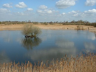
Woodwalton Fen is a 209-hectare biological Site of Special Scientific Interest in the parish of Woodwalton, west of Ramsey in Huntingdonshire, Cambridgeshire, England. It is a Ramsar wetland site of international importance, a National Nature Reserve, a Special Area of Conservation and a Nature Conservation Review site, Grade I. The site is managed by Natural England.
Moreton Valence is a village and civil parish 6 miles (9.7 km) south-west of Gloucester, Gloucestershire, England. The village is on the A38, just east from the river Severn. The estimated population of the civil parish in 2016 was 165.
Holkham Camp, or Holkham Fort, is an Iron Age fort in Norfolk, England, about 1 mile (1.6 km) north-west of the village of Holkham. It is a scheduled monument.

