
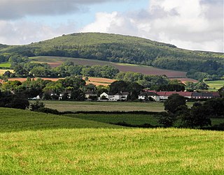
Nether Stowey is a large village in Somerset, South West England. It sits in the foothills of the Quantock Hills, just below Over Stowey. The parish of Nether Stowey covers approximately 4 km2, with a population of 1,482.

The Quantock Hills west of Bridgwater in Somerset, England, consist of heathland, oak woodlands, ancient parklands and agricultural land. They were England's first Area of Outstanding Natural Beauty, designated in 1956.

Pickering Castle is a motte-and-bailey fortification in Pickering, North Yorkshire, England. The original castle was made of timber, and the later stone castle was a temporary prison for Richard II in 1399.

Christchurch Castle is a Norman motte and bailey castle in Christchurch, Dorset, England. The earliest stonework has been dated to 1160. The castle's site is inside the old Saxon burh dominating the River Avon's lowest crossing.
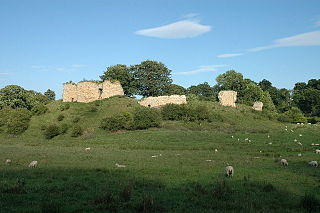
Dowsborough Camp is an Iron Age hill fort on the Quantock Hills near Nether Stowey in Somerset, England. It has been designated as a Scheduled Monument. The fort and associated round barrow has been added to the Heritage at Risk Register due to vulnerability to vehicle damage and erosion.
Anstey Castle was in the village of Anstey, Hertfordshire. It was a 12th-century stone motte and bailey fortress that, according to tradition, was founded by Eustace II, Count of Boulogne. It was either him, or one of his immediate progeny who established the first earthwork castle here. The castle had most probably been in existence for some time when the estate was acquired by Geoffrey de Mandeville, for he sought to strengthen his estate in the surrounding valley. It passed into the hands of the de Anstey family in the middle of the 12th century and was strengthened during the First Barons' War of 1215–1216 by Nicholas de Anstey, an opponent of King John, fighting for the barons. After the war ended de Anstey was commanded in 1218 to destroy the castle, with only those parts to remain that had been built before the war. The material from this demolition was supposed to be used in order to repair the nearby church, therefore the crest and shield from the castle feature in the church graffiti.
Mitford Castle is an English castle dating from the end of the 11th century and located in the village of Mitford, Northumberland, to the west of Morpeth. It is a Scheduled Ancient Monument and a Grade I listed building, enlisted on 20 October 1969. The castle is also officially on the Buildings at Risk Register. The Norman motte and bailey castle stands on a small prominence, a somewhat elliptical mound, above the River Wansbeck. The selected building site allowed for the natural hill to be scarped and ditched, producing the motte.

Over Stowey is a small village and civil parish in Somerset, South West England. A large part of the forest and open heath of the Quantock Hills is within the parish and it includes the hamlets of Plainsfield, Aley, Adscombe, Friarn and Bincombe. It is adjacent to Nether Stowey, 8 miles (13 km) north-west of Bridgwater.

While there are many castles in South Yorkshire, the majority are manor houses and motte-and-bailey which were commonly found in England after the Norman Conquest.

The Grade I listed buildings in Somerset, England, demonstrate the history and diversity of its architecture. The ceremonial county of Somerset consists of a non-metropolitan county, administered by Somerset County Council, which is divided into five districts, and two unitary authorities. The districts of Somerset are West Somerset, South Somerset, Taunton Deane, Mendip and Sedgemoor. The two administratively independent unitary authorities, which were established on 1 April 1996 following the breakup of the county of Avon, are North Somerset and Bath and North East Somerset. These unitary authorities include areas that were once part of Somerset before the creation of Avon in 1974.
Down End Castle, also known as Downend Castle, Chisley Mount or Chidley Mount, was a motte-and-bailey castle at Down End, north of Dunball in the parish of Puriton, Somerset, England. It has been designated as a Scheduled Ancient Monument.

Wareham Castle and the town defences, known locally as the Walls, were fortifications in the town of Wareham in Dorset, England.
There are over 670 scheduled monuments in the ceremonial county of Somerset in South West England. The county consists of a non-metropolitan county, administered by Somerset County Council, which is divided into five districts, and two unitary authorities. The districts of Somerset are West Somerset, South Somerset, Taunton Deane, Mendip and Sedgemoor. The two administratively independent unitary authorities, which were established on 1 April 1996 following the breakup of the county of Avon, are North Somerset and Bath and North East Somerset. These unitary authorities include areas that were once part of Somerset before the creation of Avon in 1974.
The Anglican Church of St Mary the Virgin in Nether Stowey in the English county of Somerset has a 15th-century tower, with the remainder of the church being rebuilt in 1851 by Richard Carver and Charles Edmund Giles. It is as a Grade II* listed building.

Snodhill Castle is a ruined motte-and-bailey castle, about 1 mi (1.6 km) south of the village of Dorstone in west Herefordshire, England. It is recognized as one of the major castles of the Welsh Marches. It was built in the 11th century to secure the border between Norman England and the Welsh Princes. Archaeological excavations show that it was one of the first Norman castles in England to have stone-built fortifications, with more sophisticated defenses being added in later centuries.


