Stowlangtoft

Last updated

Stowlangtoft
Stowlangtoft - Church of St George.jpg
Church of St George
Suffolk UK location map.svg
Red pog.svg
Stowlangtoft
Location within Suffolk
Population270 (2005) [1]
228 (2011) [2]
District
Shire county
Region
Country England
Sovereign state United Kingdom
Post town Bury St Edmunds
Postcode district IP31
Police Suffolk
Fire Suffolk
Ambulance East of England
List of places
UK
England
Suffolk
52°16′37″N0°52′26″E / 52.277°N 0.874°E / 52.277; 0.874

Stowlangtoft is a village and civil parish in the Mid Suffolk district of Suffolk in eastern England two miles south-east from Ixworth. Located around five miles north-east of Bury St Edmunds, in 2005 its population was 270. [1]

Contents

Name

The village, originally just Stow, was held by the de Languetot family in the early 13th century. [3]

St George's Church

For all of Stowlangtoft's small size, St George's is within the group classed as "Great Churches". Simon Jenkins included it in his book England's Thousand Best Churches. [4] The church was built as a single construction project in the late 14th century and barely changed until the restoration work undertaken in the 19th century. The church is in the decorated and later English styles; the chancel contains several richly-carved stalls and monuments to members of the family of D'Ewes. [5] The church and parsonage-house are located on what was once the site of a Roman encampment. [5] Peter Tillemans, one of the founders of the English school of sporting painting, was buried in St George's on 7 December 1734. [6]

Samuel Rickards was rector here for several decades in the mid nineteenth century. [4]

At some point after the Dissolution of the monasteries, St George's acquired six 14th-century misericords. It is not clear where these misericords originated, but possible candidates are Thetford Priory or Bury Abbey. [7]

Stowlangtoft Hall

Stowlangtoft Hall, built 1859 by David Mocatta, painted in 1880, by Francis Orpen Morris Stowlangtoft Hall, F. O. Morris volume 3, 1880.png
Stowlangtoft Hall, built 1859 by David Mocatta, painted in 1880, by Francis Orpen Morris

Sir Symonds D'Ewes, Bart., the eminent antiquary, lived in Stowlangtoft Hall. [5] The Hall was rebuilt in 1859 for Fuller Maitland Wilson. [8]

In 2011 a gruesome-looking tree in the grounds the hall attracted public attention. [8]

Notable residents

Related Research Articles

<span class="mw-page-title-main">Bury St Edmunds</span> Town in Suffolk, England

Bury St Edmunds, commonly referred to locally as Bury, is a historic market and cathedral town and civil parish in Suffolk, England. The town is best known for Bury St Edmunds Abbey and St Edmundsbury Cathedral. Bury is the seat of the Diocese of St Edmundsbury and Ipswich of the Church of England, with the episcopal see at St Edmundsbury Cathedral.

<span class="mw-page-title-main">Norton, Suffolk</span> Human settlement in England

Norton is a village and civil parish in the Mid Suffolk district of the English county of Suffolk. The name Norton means northern town or farm. Located close to the A14, its nearest railway station is at Elmswell, just over 3 miles (5 km) away. The closest towns are Stowmarket 8 miles (13 km) away and Bury St Edmunds, around 10 miles (16 km) away.

<span class="mw-page-title-main">Corton, Suffolk</span> Human settlement in England

Corton is a village and civil parish in the north of the English county of Suffolk. It is 3 miles (4.8 km) north of the centre of Lowestoft in the East Suffolk district. The village is on the North Sea coast with the county border with Norfolk to the north. It is a seaside holiday centre, with a number of facilities for visitors. Great Yarmouth is 6 miles (9.7 km) to the north.

<span class="mw-page-title-main">Blundeston</span> Village in Suffolk, England

Blundeston is a village and civil parish in the north of the English county of Suffolk. It is 3.5 miles (5.6 km) north-west of Lowestoft, 6 miles (9.7 km) south of Great Yarmouth and around 1.75 miles (2.82 km) inland from the North Sea coast. It is part of the area known as Lothingland in the East Suffolk district. Blundeston Prison was located on the southern edge of the village but closed in early 2014.

<span class="mw-page-title-main">Haddiscoe</span> Human settlement in England

Haddiscoe is a village and civil parish in the South Norfolk district of Norfolk, England, about 16 miles (26 km) southeast of Norwich. The parish is on the county boundary with Suffolk, about 7 miles (11 km) west-northwest of Lowestoft. The parish includes the hamlet of Thorpe-next-Haddiscoe, about 1 mile (1.6 km) north of Haddiscoe village.

<span class="mw-page-title-main">Little Livermere</span> Human settlement in England

Little Livermere is a village and civil parish in England situated about 5 miles (8 km) north of Bury St Edmunds, in an area of Suffolk known as the Breckland. The population at the 2011 Census is included in the civil parish of Ampton.

<span class="mw-page-title-main">Redgrave, Suffolk</span> Human settlement in England

Redgrave is a village and civil parish in Suffolk, England, just south of the River Waveney that here forms the county boundary with Norfolk. The village is about 4+12 miles (7 km) west of the town of Diss. The 2011 Census recorded the parish population as 459.

<span class="mw-page-title-main">Hunston, Suffolk</span> Human settlement in England

Hunston is a small Suffolk village and civil parish set in a conservation area of Mid-Suffolk and lies between Stowlangtoft and Badwell Ash off the A1088, nearly eight miles east of the centre of Bury St Edmunds. It is set in flattish farmland, mostly arable.

<span class="mw-page-title-main">Ilketshall St Andrew</span> Human settlement in England

Ilketshall St Andrew is a village and civil parish in the north of the English county of Suffolk. It is 3 miles (4.8 km) south-east of Bungay and the same distance south-west of Beccles in the East Suffolk district. St Andrew's church is one of around 40 round-tower churches in Suffolk.

Bradfield St. George is a village and civil parish in the West Suffolk district of Suffolk, England, about 6 miles (9.7 km) south of Bury St Edmunds.

<span class="mw-page-title-main">Thorpe Morieux</span> Human settlement in England

Thorpe Morieux is a small village and civil parish in Suffolk, England. It is 10 miles south-east of Bury St Edmunds and 10 miles north east of Sudbury.

<span class="mw-page-title-main">D'Ewes Coke</span>

D'Ewes Coke was rector of Pinxton and South Normanton in Derbyshire, a colliery owner and philanthropist.

<span class="mw-page-title-main">Fornham St Genevieve</span> Human settlement in England

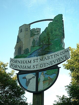
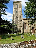
Fornham St Genevieve is a village and civil parish in the West Suffolk district of Suffolk in eastern England. It is one of a trio of contiguous villages by the River Lark. The other villages are Fornham All Saints and Fornham St Martin.

<span class="mw-page-title-main">Thomas Jermyn, 2nd Baron Jermyn</span> English politician and peer

Thomas Jermyn, 2nd Baron Jermyn was an English politician who sat in the House of Commons from 1679 until he inherited a peerage in 1684.

<span class="mw-page-title-main">Stanningfield</span> Village in Suffolk, England

Stanningfield is a village and former civil parish, now in the parish of Bradfield Combust with Stanningfield, in the West Suffolk district of the county of Suffolk, England. The village lies just off of the A134 road, about 5 miles (8 km) south-east of Bury St Edmunds, 5 miles/8 km north-west of Lavenham, and 10 miles/16 km north of Sudbury. In 1961 the parish had a population of 211.

<span class="mw-page-title-main">Stratford St Andrew</span> Human settlement in England

Stratford St Andrew is a small village and a civil parish just off the A12 road, in the East Suffolk district, in the English county of Suffolk. It lies 3 miles south west of Saxmundham, the nearest town.

<span class="mw-page-title-main">St Cross South Elmham</span> Human settlement in England

St Cross South Elmham is a village and civil parish in the north of the English county of Suffolk. It is in the East Suffolk district, close to the border with Norfolk and is 3 miles (4.8 km) east of Harleston and 4.25 miles (6.84 km) south-west of Bungay. It is one of the villages around Bungay known as the Saints.

<span class="mw-page-title-main">St Mary the Virgin's Church, Cavendish</span> Church in Suffolk, England

St Mary the Virgin's Church, Cavendish is a Grade I listed parish church in the Church of England in Cavendish, Suffolk.

Fuller Maitland Wilson was a British Conservative Party politician.

<span class="mw-page-title-main">Cox Macro</span>

Cox Macro was an Anglican priest, and antiquarian. He accumulated a large collection of antiquities at his home, Little Haugh Hall near Norton, Suffolk.

References

  1. 1 2 Estimates of Total Population of Areas in Suffolk Archived 2008-12-19 at the Wayback Machine Suffolk County Council
  2. "Civil Parish population 2011". Neighbourhood Statistics. Office for National Statistics. Retrieved 28 August 2016.
  3. Ekwall, Eilert The Concise Oxford Dictionary of English Place-Names (4th ed., 1960) p. 448
  4. 1 2 Knott, Simon. "St George, Stowlangtoft". www.suffolkchurches.co.uk. Simon Knott. Retrieved 6 December 2021.
  5. 1 2 3 Stoven - Stowick, A Topographical Dictionary of England (1848), pp. 234-38 british-history.ac.uk, accessed 17 April 2009
  6. Noakes, Aubrey, Sportsmen in a Landscape (Ayer Publishing, 1971, ISBN   0-8369-2005-8), pp. 47–56: Peter Tillemans and Early Newmarket at books.google.com, accessed 7 February 2009
  7. Suffolk Churches website, entry for Stowlangtoft, accessed 7 February 2013
  8. 1 2 Thewlis, Jo (14 June 2011). "Bury St Edmunds: Is the world's scariest tree lurking right here in Suffolk?". East Anglian Daily Times. Archant. Retrieved 6 December 2021.

Commons-logo.svg Media related to Stowlangtoft at Wikimedia Commons