
San Marino, officially the Republic of San Marino and also known as the Most Serene Republic of San Marino, is a European microstate and country enclaved by Italy. Located on the northeastern side of the Apennine Mountains, San Marino is the fifth-smallest country in the world and covers a land area of just over 61 km2, with a population of 33,660 as of 2022.

The Republic of San Marino's public transport network consists of a local bus network and the Funivia di San Marino, an aerial cablecar system between Borgo Maggiore and the City of San Marino. Both means are operated by the Azienda Autonoma di Stato per i Servizi Pubblici, the Sammarinese state company for public transport.

Rimini is a city in the Emilia-Romagna region of Northern Italy and capital city of the province of Rimini. It sprawls along the Adriatic Sea, on the coast between the rivers Marecchia and Ausa. It is one of the most notable seaside resorts in Europe with revenue from both internal and international tourism forming a significant portion of the city's economy. It is also near San Marino, a small nation within Italy. The first bathing establishment opened in 1843. Rimini is an art city with ancient Roman and Renaissance monuments, and is also the birthplace of the film director Federico Fellini.
The Via Flaminia was an ancient Roman road leading from Rome over the Apennine Mountains to Ariminum (Rimini) on the coast of the Adriatic Sea, and due to the ruggedness of the mountains was the major option the Romans had for travel between Etruria, Latium, Campania, and the Po Valley. The section running through northern Rome is where Constantine the Great, allegedly, had his famous vision of the Chi Rho, leading to his conversion to Christianity and the Christianization of the Roman Empire.

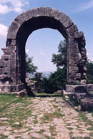
The City of San Marino is the capital city of the Republic of San Marino. It has a population of 4,061. It is on the western slopes of San Marino's highest point, Monte Titano.
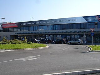
Rimini and San Marino "Federico Fellini" International Airport, formerly Rimini Miramare Airport, is an international airport located in Rimini, Italy.

Antrodoco is a town and comune in the province of Rieti, in the Lazio region of central Italy. The name derives from the Latin Interocrea.

Dogana is a town and a civil parish (curazia), whose name means "Customs House"; it is located in the north-eastern corner of San Marino in the Serravalle municipality ("castello"). The town is the most populated settlement in the San Marino.

Rovereta is a village (curazia) in San Marino. It belongs to the municipality (castello) of Serravalle. Its name, in Italian language, refers to a wood of "Sessile Oaks".

Torraccia is a small village (curazia) located in San Marino. It belongs to the municipality (castello) of Domagnano.

The Stura di Demonte Valley is a valley in south-west of Piedmont in the Province of Cuneo, Italy.

The strada statale 18 "Tirrena Inferiore" is an Italian state road, connecting Campania and Calabria. It is among the longest and most important state highways in southern Italy, considering that it follows the Tyrrhenian coast, from Salerno to Reggio di Calabria.

The strada statale 234 "Codognese" was an Italian state road, created in 1959 and disestablished in 2000. It began in Pavia and ended in Cremona, going through the Po Valley in the Lombardy region.

The Rimini–San Marino railway was a 31.5-kilometre (19.6-mile) electrified narrow gauge railway that connected Rimini, Italy, with the City of San Marino, Republic of San Marino.
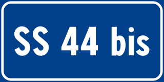
Strada statale 44 bis Passo del Rombo is a motorway that connects Passeier Valley with Austria.

Strada statale 44 del Passo di Giovo is a motorway which connects Etschtal with Eisacktal passing through Passeier Valley and Jaufen Valley.

Strada statale 44 delle Dolomiti, also known as strada regionale 48 delle Dolomiti is a motorway located in the Italian regions of Trentino-Alto Adige/Südtirol and Veneto. It is a mountainous road that runs through the Dolomite area from South Tyrol, through Trentino to Cadore, crossing very suggestive mountain scenery.

Strada statale 37 del Maloja is a motorway located in the Italian region of Lombardy.

Strada statale 35 dei Giovi is an Italian state highway, which connects Genoa and the Italian Riviera with Como and the Canton of Ticino, passing through Pavia and Milan. The road begins in Genoa in the Sampierdarena district where it constitutes an important urban crossing artery with the Reti and Fillak streets, and then ends in Como more precisely at the Customs House in Ponte Chiasso on the border with Switzerland. Between Tortona and Casteggio the SS 35 is in common with the strada statale 10, while the Milan-Cermenate section is a Superstrada, built around the 1960s known as Superstrada Milano-Meda.

Strada statale 7 Via Appia is a motorway that follows the path of the ancient Appian Way, connecting Rome to Brindisi. In the stretch between Cisterna di Latina and Terracina, the SS 7 is called "fettuccia di Terracina" due to its straight line.

