Stramshall

Last updated

Stramshall
St Michael's and All Angels at Stramshall.jpg
Saint Michael and All Angels' parish church, Stramshall, Staffordshire.
Staffordshire UK location map.svg
Red pog.svg
Stramshall
Location within Staffordshire
OS grid reference SK0735
  London 143 mi (230 km)
Civil parish
District
Shire county
Region
Country England
Sovereign state United Kingdom
Post town UTTOXETER
Postcode district ST14 5
Dialling code 01889
Police Staffordshire
Fire Staffordshire
Ambulance West Midlands
UK Parliament
List of places
UK
England
Staffordshire
52°55′11″N1°52′51″W / 52.91982°N 1.88089°W / 52.91982; -1.88089

Stramshall is a village within the civil parish of Uttoxeter Rural in the county of Staffordshire, England. [1] The village is 2.1 miles (3.4 km) north of the town of Uttoxeter, 16.3 miles (26.2 km) north east of Stafford and 143 miles (230 km) north west of London. The village lies 0.8 miles (1.3 km) north of the A50 that links Warrington to Leicester. [2] The nearest railway station is at Uttoxeter for the Crewe to Derby line. The nearest airport is East Midlands Airport.

Contents

History

Stramshall has an entry in the Domesday Book of 1086 where it is recorded by the name Stagrigesholle. [3] The manor was owned by the King and the main tenant was Alric who had owned the manor before the Norman Conquest.
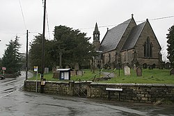
Parish Council

Stramshall falls within the civil parish known as Uttoxeter Rural. The council meets once a month and they hold their meetings in the village halls of both Stramshall and the nearby village of Bramshall which they use alternately each month. The village hall in Stramshall was built in 1979 and is located in Vicarage Drive.

Parish Church of Saint Michael and All Saints

The parish church was built between 1850 and 1852 and was made a separate ecclesiastic parish in 1853.

Stramshall Football Club

Stramshall Football Club is an amateur club based in the Staffordshire area. It was founded in 2005 to raise funds to refurbish the local playing field. Their kit consists of a yellow shirt with black sleeves, black Shorts and white socks. The team hold a Lads v Dads charity football game annually to help with this cause.

See also

Related Research Articles

<span class="mw-page-title-main">Uttoxeter</span> Market town in Staffordshire, England

Uttoxeter is a market town and civil parish in the East Staffordshire borough of Staffordshire, England. It is near to the Derbyshire county border.

<span class="mw-page-title-main">Mickleover</span> Human settlement in England

Mickleover is a village in the unitary authority of Derby, in Derbyshire, England. It is 2 miles (3.2 km) west of Derby, 10 miles (16 km) northeast of Burton upon Trent, 19 miles (31 km) west of Nottingham, 13 miles (21 km) southeast of Ashbourne and 12 miles (19 km) northeast of Uttoxeter.

<span class="mw-page-title-main">Doveridge</span> Human settlement in England

Doveridge is a village and civil parish in Derbyshire, United Kingdom, near the border with Staffordshire and about 2 km (1.2 mi) east of Uttoxeter. Its name may come from its having a bridge over the river Dove, a tributary of the River Trent. The civil parish population as taken at the 2011 Census was 1,622.

<span class="mw-page-title-main">Hixon, Staffordshire</span> Human settlement in England

Hixon is a village and a civil parish in the English county of Staffordshire.
grid reference SK003259

<span class="mw-page-title-main">Adbaston</span> Civil parish in Staffordshire, England

Adbaston is a village and a civil parish in the English county of Staffordshire.

<span class="mw-page-title-main">Rocester</span> Human settlement in England

Rocester is a village and civil parish in the East Staffordshire district of Staffordshire, England. Its name is spelt Rowcestre in the Domesday Book. It is located on the Derbyshire border.

<span class="mw-page-title-main">Hatton, Derbyshire</span> Human settlement in England

Hatton is a village and civil parish in South Derbyshire, England. It is 5 miles (8.0 km) north of Burton upon Trent, 10 miles (16 km) south-west of Derby and 24 miles (39 km) south-east of Stoke-on-Trent. The population of the civil parish as of the 2011 census was 2,785. It adjoins Tutbury to the south.

<span class="mw-page-title-main">Marchington</span> Human settlement in England

Marchington is a small village in East Staffordshire, England. It lies between the towns of Burton upon Trent and Uttoxeter. Marchington has a small community-run shop, a first school, two churches and two pubs. The population of the village was 1,127 at the 2001 census, increasing to 2,017 at the 2011 census.

<span class="mw-page-title-main">Bramshall</span> Human settlement in England

Bramshall is a village and former civil parish, now in the parish of Uttoxeter Rural, in the East Staffordshire district, in the county of Staffordshire, England. It is to the west of Uttoxeter. It has a new housing estate to the north of it. In 1931 the parish had a population of 173.

<span class="mw-page-title-main">Marchington Woodlands</span> Human settlement in England

Marchington Woodlands is a village and former civil parish, now in the parish of Marchington, in the East Staffordshire district, in the county of Staffordshire, England. It has a church and a village hall. The local first school was closed in 1981 and the building was converted into a private home. Marchington Woodlands consists mostly of farms and cottages. it is often Referred to by locals as The Woodlands. It is located near Uttoxeter. In 1931 the parish had a population of 273.

<span class="mw-page-title-main">Rushall, West Midlands</span> Suburban Village in Walsall, West Midlands, England

Rushall is a suburb in the Metropolitan Borough of Walsall in the West Midlands, England. It is centred on the main road between Walsall and Lichfield. It is mentioned in the Domesday Book but has mostly developed since the 1920s. Rushall was historically a part of the county of Staffordshire before it was incorporated with much of the old Aldridge-Brownhills Urban District into the modern-day Walsall district.

Denstone is a village and civil parish situated between the towns of Uttoxeter in East Staffordshire and Ashbourne in Derbyshire. It is located next to the River Churnet. The village has a church, village hall, primary school and a pub. The nearest railway station is at Uttoxeter for the Crewe to Derby line and the nearest airport is East Midlands Airport.

<span class="mw-page-title-main">Leigh, Staffordshire</span> Human settlement in England

Leigh is a civil parish in the English county of Staffordshire. The parish includes the village of Church Leigh, together with the settlements of Withington, Upper Leigh, Lower Leigh, Morrilow Heath, Middleton Green, Dodsley, Godstone, Nobut and Field.

<span class="mw-page-title-main">Weston, Staffordshire</span> Human settlement in England

Weston is a village and civil parish. within the English county of Staffordshire. The parish is in the local authority of Stafford.

<span class="mw-page-title-main">Hollington, Staffordshire</span> Human settlement in England

Hollington is a village in the Staffordshire Moorlands district in Staffordshire, England. There are several villages of this name, including Hollington, Derbyshire a few miles to the east in the county of Derbyshire. The population taken at the 2011 census was 212.

<span class="mw-page-title-main">The Heath, Staffordshire</span> Village near Uttoxeter in Staffordshire, England

The Heath is a village in the East Staffordshire borough of Staffordshire, England. It is close to the border with Derbyshire. The village adjoins the town of Uttoxeter and the villages of Bramshall and Spath.

<span class="mw-page-title-main">Tean, Staffordshire</span> Human settlement in England

Tean is a large village in Staffordshire, England. It is around 15 miles (24 km) south-east of Stoke-on-Trent. The River Tean runs through the village, heading east towards Uttoxeter. Population details for the 2011 census can be found under Checkley.

<span class="mw-page-title-main">Checkley</span> Human settlement in England

Checkley is a village and civil parish in the district of Staffordshire Moorlands in the English county of Staffordshire.

<span class="mw-page-title-main">Kingstone, Staffordshire</span> Human settlement in England

Kingstone is a village and civil parish within the English county of Staffordshire.

<span class="mw-page-title-main">Milwich</span> Human settlement in England

Milwich is a village and a civil parish in the English county of Staffordshire.

References

  1. OS Explorer Map 259, Derby, Ashbourne & Cheadle. ISBN   0-319-21895-3
  2. A to Z East Midlands Road Map, ISBN   1-84348-283-5
  3. The Domesday Book, England's Heritage, Then and Now, editor: Thomas Hinde, Shropshire, Stramshall, page 230, ISBN   1-85833-440-3