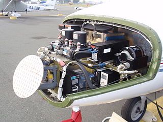
Avionics are the electronic systems used on aircraft. Avionic systems include communications, navigation, the display and management of multiple systems, and the hundreds of systems that are fitted to aircraft to perform individual functions. These can be as simple as a searchlight for a police helicopter or as complicated as the tactical system for an airborne early warning platform.

In aviation, a flight level (FL) is an aircraft's altitude as determined by a pressure altimeter using the International Standard Atmosphere. It is expressed in hundreds of feet or metres. The altimeter setting used is the ISA surface pressure of 1013 hPa or (29.92 inHg). The actual surface pressure may vary from this at different locations and times. Therefore, by using a standard pressure setting, every aircraft has the same altimeter setting, and vertical clearance can be maintained.
The basic principles of air navigation are identical to general navigation, which includes the process of planning, recording, and controlling the movement of a craft from one place to another.
In aviation, uncontrolled airspace is airspace in which an Air Traffic Control (ATC) service is not deemed necessary or cannot be provided for practical reasons. It is the opposite of controlled airspace. It is that portion of the airspace that has not been designated as Control Area, Control Zone, Terminal Control Area or Transition Area.
Reduced vertical separation minimum (RVSM) is the reduction, from 2,000 feet to 1,000 feet, of the standard vertical separation required between aircraft flying between flight level 290 (29,000 ft) and flight level 410 (41,000 ft). Expressed in the International System of Units (SI), it is the reduction, from 600 m to 300 m, of required vertical separation of aircraft between altitudes 8,850 and 12,500 m. This reduction in vertical separation minimum therefore increases the number of aircraft that can fly in a particular volume of controlled airspace.

The Irish Aviation Authority (IAA) is a commercial semi-state company in Ireland responsible for the regulation of safety aspects of air travel. Its head office is in The Times Building in Dublin.

A traffic alert and collision avoidance system is an aircraft collision avoidance system designed to reduce the incidence of mid-air collision (MAC) between aircraft. It monitors the airspace around an aircraft for other aircraft equipped with a corresponding active transponder, independent of air traffic control, and warns pilots of the presence of other transponder-equipped aircraft which may present a threat of MAC. It is a type of airborne collision avoidance system mandated by the International Civil Aviation Organization to be fitted to all aircraft with a maximum take-off mass (MTOM) of over 5,700 kg (12,600 lb) or authorized to carry more than 19 passengers. CFR 14, Ch I, part 135 requires that TCAS I be installed for aircraft with 10-30 passengers and TCAS II for aircraft with more than 30 passengers. ACAS/TCAS is based on secondary surveillance radar (SSR) transponder signals, but operates independently of ground-based equipment to provide advice to the pilot on potentially conflicting aircraft.

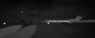
On 12 November 1996, Saudia Flight 763, a Boeing 747 en route from Delhi, India, to Dhahran, Saudi Arabia, and Kazakhstan Airlines Flight 1907, an Ilyushin Il-76 en route from Chimkent, Kazakhstan, to Delhi, collided over the city of Charkhi Dadri, around 100 km west of Delhi. The crash killed all 349 people on board both planes, making it the world's deadliest mid-air collision and the deadliest aviation accident ever in India. The final report from the investigation found that "[T]he root and approximate cause of the collision" was the failure of the Kazakh crew to maintain the correct altitude. Contributing factors included the poor English language skills in the Kazakh cockpit resulting in inadequate interpretation of directions provided by air traffic control, and three specific incidents of failures in crew resource management (CRM) by the Kazakh crew. The report also suggested technical enhancements that would provide assistance in preventing a future crew's mistakes being allowed to go unchecked in real time.
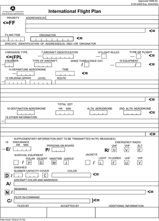
Flight plans are documents filed by a pilot or flight dispatcher with the local Air Navigation Service Provider prior to departure which indicate the plane's planned route or flight path. Flight plan format is specified in ICAO Doc 4444. They generally include basic information such as departure and arrival points, estimated time en route, alternate airports in case of bad weather, type of flight, the pilot's information, number of people on board, and information about the aircraft itself. In most countries, flight plans are required for flights under IFR, but may be optional for flying VFR unless crossing international borders. Flight plans are highly recommended, especially when flying over inhospitable areas such as water, as they provide a way of alerting rescuers if the flight is overdue. In the United States and Canada, when an aircraft is crossing the Air Defense Identification Zone (ADIZ), either an IFR or a special type of VFR flight plan called a DVFR flight plan must be filed. For IFR flights, flight plans are used by air traffic control to initiate tracking and routing services. For VFR flights, their only purpose is to provide needed information should search and rescue operations be required, or for use by air traffic control when flying in a "Special Flight Rules Area."

In aviation, an instrument approach or instrument approach procedure (IAP) is a series of predetermined maneuvers for the orderly transfer of an aircraft operating under instrument flight rules from the beginning of the initial approach to a landing, or to a point from which a landing may be made visually. These approaches are approved in the European Union by EASA and the respective country authorities and in the United States by the FAA or the United States Department of Defense for the military. The ICAO defines an instrument approach as "a series of predetermined maneuvers by reference to flight instruments with specific protection from obstacles from the initial approach fix, or where applicable, from the beginning of a defined arrival route to a point from which a landing can be completed and thereafter, if landing is not completed, to a position at which holding or en route obstacle clearance criteria apply."

A flight management system (FMS) is a fundamental component of a modern airliner's avionics. An FMS is a specialized computer system that automates a wide variety of in-flight tasks, reducing the workload on the flight crew to the point that modern civilian aircraft no longer carry flight engineers or navigators. A primary function is in-flight management of the flight plan. Using various sensors (such as GPS and INS often backed up by radio navigation) to determine the aircraft's position, the FMS can guide the aircraft along the flight plan. From the cockpit, the FMS is normally controlled through a Control Display Unit (CDU) which incorporates a small screen and keyboard or touchscreen. The FMS sends the flight plan for display to the Electronic Flight Instrument System (EFIS), Navigation Display (ND), or Multifunction Display (MFD). The FMS can be summarised as being a dual system consisting of the Flight Management Computer (FMC), CDU and a cross talk bus.
Required navigation performance (RNP) is a type of performance-based navigation (PBN) that allows an aircraft to fly a specific path between two 3D-defined points in space.
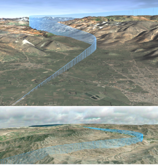
The North Atlantic Tracks, officially titled the North Atlantic Organised Track System (NAT-OTS), are a structured set of transatlantic flight routes that stretch from eastern North America to western Europe across the Atlantic Ocean, within the North Atlantic airspace region. They ensure that aircraft are separated over the ocean, where there is little radar coverage. These heavily travelled routes are used by aircraft flying between North America and Europe, operating between the altitudes of 29,000 and 41,000 ft inclusive. Entrance and movement along these tracks is controlled by special oceanic control centres to maintain separation between aircraft. The primary purpose of these routes is to allow air traffic control to effectively separate the aircraft. Because of the volume of NAT traffic, allowing aircraft to choose their own co-ordinates would make the air traffic control (ATC) task far more complex. They are aligned in such a way as to minimize any head winds and maximize tail winds impact on the aircraft. This results in much more efficiency by reducing fuel burn and flight time. To make such efficiencies possible, the routes are created twice daily to take account of the shifting of the winds aloft and the principal traffic flow, eastward in North America evening and westward twelve hours later.

Area navigation is a method of instrument flight rules (IFR) navigation that allows an aircraft to choose any course within a network of navigation beacons, rather than navigate directly to and from the beacons. This can conserve flight distance, reduce congestion, and allow flights into airports without beacons. Area navigation used to be called "random navigation", hence the acronym RNAV.
In aviation, a mid-air collision is an accident in which two or more aircraft come into unplanned contact during flight. Owing to the relatively high velocities involved and the likelihood of subsequent impact with the ground or sea, very severe damage or the total destruction of at least one of the aircraft usually results. For this reason, accidents involving mid-air collisions especially during cruise frequently result in very few survivors or, more often, a total lack thereof. This is especially when the accident involves jet aircraft.

In air traffic control, separation is the name for the concept of keeping an aircraft outside a minimum distance from another aircraft to reduce the risk of those aircraft colliding, as well as prevent accidents due to secondary factors, such as wake turbulence. Separation can also apply to terrain, obstacles, and controlled airspace, wherein an aircraft must stay at a minimum distance from a block of airspace; as an example, all aircraft must be approved by the controller who "owns" the airspace before the aircraft is approved to enter that sector.
In aviation, an air traffic service (ATS) is a service which regulates and assists aircraft in real-time to ensure their safe operations. In particular, ATS is to:
The navigation paradox states that increased navigational precision may result in increased collision risk. In the case of ships and aircraft, the advent of Global Positioning System (GPS) navigation has enabled craft to follow navigational paths with such greater precision, that, without better distribution of routes, coordination between neighboring craft and collision avoidance procedures, the likelihood of two craft occupying the same space on the shortest distance line between two navigational points has increased.
ICAO performance-based navigation (PBN) specifies that aircraft required navigation performance (RNP) and area navigation (RNAV) systems performance requirements be defined in terms of accuracy, integrity, availability, continuity, and functionality required for the proposed operations in the context of a particular airspace, when supported by the appropriate navigation infrastructure.
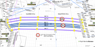
Reduced Lateral Separation Minima, is an aeronautical flight term identifying the reduction from standard lateral separation minima between aircraft to a lower amount deemed safe, first introduced on the North Atlantic in December 2015 for the North Atlantic Tracks.
