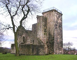
Crookston Castle is a ruined medieval castle in the Pollok area of Glasgow, Scotland. It is located some five miles southwest of the city centre, on a hill overlooking the Levern Water, just before its confluence with the White Cart Water. Crookston Castle was built by the Stewarts of Darnley around 1400, and is set within earthworks constructed in the 12th century. Once the property of the earls and dukes of Lennox, the castle was extensively repaired following a siege in 1544, and it is the only surviving medieval castle in Glasgow.

Craignethan Castle is a ruined castle in South Lanarkshire, Scotland. It is located above the River Nethan, a tributary of the River Clyde, at NS816464. The castle is two miles west of the village of Crossford, and 4.5 miles north-west of Lanark. Built in the first half of the 16th century, Craignethan is recognised as an excellent early example of a sophisticated artillery fortification, although its defences were never fully tested.

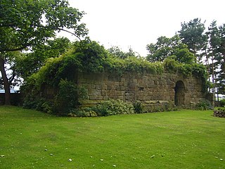
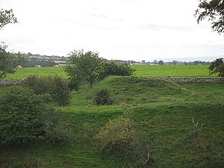
Crawford Castle, substantially in ruins, is located on the north bank of the River Clyde, around 1⁄2 mile north of Crawford, South Lanarkshire, Scotland. The ruins stand on an earlier motte and bailey earthwork. The castle is also known as Lindsay Tower, after its former owners, the Lindsay family. The strategic location of the castle, at NS954213, guards the strategically important Mennock Pass from England into the upper Clyde Valley.
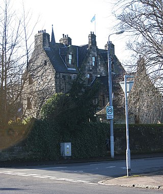
Haggs Castle is a 16th-century tower house, located in the neighbourhood of Pollokshields, in Glasgow, Scotland. The richly decorated building was restored in the 19th century, and today is once more occupied as a residence.
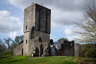
Gilnockie Tower is a 16th-century tower house, located at the hamlet of Hollows, 2.3 km north of Canonbie, in Dumfriesshire, south-west Scotland. The tower is situated on the west bank of the River Esk. It was originally known as Hollows Tower.
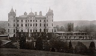
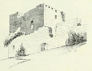
Douglas Castle was a stronghold of the Douglas family from medieval times to the 20th century. The first castle, erected in the 13th century, was destroyed and replaced several times until the 18th century when a large mansion house was built in its place. This too was demolished in 1938, and today only a single corner tower of the 17th-century castle remains. The castle was the former family seat of the Prime Minister, Sir Alec Douglas-Home. The castle was located around 1 kilometre (0.62 mi) north-east of the village of Douglas, South Lanarkshire, in south-west Scotland. The remains are protected as a category C listed building.
Bedlay Castle is a former defensive castle, dating from the late 16th and 17th centuries. It is located between Chryston and Moodiesburn in North Lanarkshire, Scotland. The castle is just off the A80 road, around 8 miles to the north-east of Glasgow, at NS692700. This castle has several ghostlore stories associated with it.
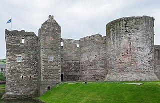
Rothesay Castle is a ruined castle in Rothesay, the principal town on the Isle of Bute, in western Scotland. Located at NS086646, the castle has been described as "one of the most remarkable in Scotland", for its long history dating back to the beginning of the 13th century, and its unusual circular plan.

Preston Tower is a ruined L-plan keep in the ancient Scottish village of Prestonpans. It is situated within a few metres of two other historic houses, Hamilton House and Northfield House.

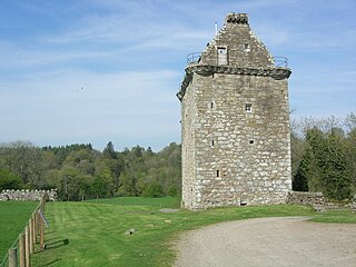
Greenknowe Tower is a 16th-century tower house, located just west of the village of Gordon, in the Scottish Borders. Although a roofless ruin, the stonework of the tower is well preserved, and represents a fine example of a later tower house, built more as a residence rather than as a place of defence. The building is located at NT639428, beside the A6105 road. It is a Scheduled Ancient Monument, and is in the care of Historic Scotland.
Mugdock Castle was the stronghold of the Clan Graham from the middle of the 13th century. Its ruins are located in Mugdock Country Park, just west of the village of Mugdock in the parish of Strathblane. The castle is within the registration county of Stirlingshire, although it is only 2 kilometres (1.2 mi) north of Milngavie, East Dunbartonshire, on the northern outskirts of Greater Glasgow.
Cathcart Castle was a 15th-century castle, located in what is now Linn Park in the Cathcart area of southern Glasgow, Scotland. The castle was abandoned in the 18th century, and the remaining ruins were pulled down in 1980, leaving only foundations visible.

Almond Castle is a ruined L-plan castle dating from the 15th century. It is located 3 miles (4.8 km) west of Linlithgow, and north of the Union Canal, in Falkirk, Scotland. It was known as Haining Castle until the 17th century. The structure is unsound and is protected as a scheduled monument.

Murieston Castle is a ruined tower house, dating from the 16th century, 2 miles (3.2 km) west of West Calder, west of the Murieston Water, at Murieston Castle Farm, West Lothian, Scotland. It is a scheduled monument and between 1971 and 2018 it was a Category B listed building.
Elphinstone Tower is a ruined 13th–15th century keep, about 4 miles (6.4 km) south east of Tranent, East Lothian, Scotland, and 0.5 miles (0.8 km) west of the village of Elphinstone, East Lothian.
Billie Castle is a ruined 15th-century quadrangular castle, 3 miles (4.8 km) north west of Chirnside, Scottish Borders, Scotland, north of Billiemains. It was designated as a scheduled monument in 1988.

Markle Castle, or Markle is a ruined 14th-century castle, about 0.5 miles (0.8 km) near the hamlet of Markle, north west of East Linton, East Lothian, Scotland, near the East Coast Main Line.

Corsbie Castle is a ruined 16th-century tower house, about 2.5 miles (4.0 km) west of Gordon, Scottish Borders, Scotland, and north of the Eden Water. It was also known as Corsbie Tower. It has been designated as a scheduled monument.
Fulton Tower is a ruined 16th century tower house, about 4.5 miles (7.2 km) south west of Jedburgh, Scottish Borders, Scotland, and about 2 miles (3.2 km) south of Bedrule, east of the Rule Water.
Posso Tower is a 16th-century tower house, about 6.0 miles (9.7 km) south and west of Peebles, Scottish Borders, Scotland, and west of Manor Water.


