
Inverness Highlands North is an unincorporated area and census-designated place (CDP) in Citrus County, Florida, United States. The population was 2,401 at the 2010 census, up from 1,470 in 2000.

Loraine is a village in Adams County, Illinois, United States. The population was 313 at the 2010 census.

Shannon is a village in Carroll County, Illinois, United States. The population was 757 at the 2010 census, down from 854 in 2000.

Kinderhook is a village in Pike County, Illinois, United States. The population was 216 at the 2010 census, a decline from 249 in 2000.
Somers is a city in Calhoun County, Iowa, United States. The population was 113 at the 2010 census.

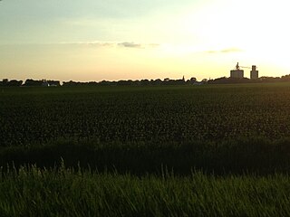
Whiting is a city in Monona County, Iowa, United States. The population was 762 at the 2010 census.

Inkster is a small village in Grand Forks County, North Dakota, United States, with a population of 50 as of the 2010 census. Inkster was founded in 1884, in an area that had been settled by George T. Inkster in 1878.

Seneca is a census-designated place (CDP) in Venango County, Pennsylvania, in the United States. As of the 2000 census, the CDP population was 966.

Hecla is a city in Brown County, South Dakota, United States, located only a few miles south of the North Dakota border. The population was 227 at the 2010 census. State Highway 37 runs along the east side of town.

Cambridgeport is one of the neighborhoods of Cambridge, Massachusetts. It is bounded by Massachusetts Avenue, the Charles River, the Grand Junction Railroad, and River Street. The neighborhood contains predominantly residential homes, many of the triple decker style common in New England. Central Square, at the northernmost part of Cambridgeport, is an active commercial district and transportation hub, and University Park is a collection of renovated or recently constructed office and apartment buildings. The neighborhood also includes Fort Washington Park, several MIT buildings, and Magazine Beach.
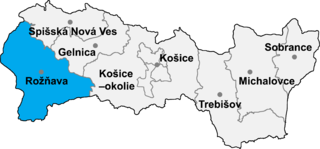
Gemerská Hôrka is a village and municipality in the Rožňava District in the Košice Region of middle-eastern Slovakia.
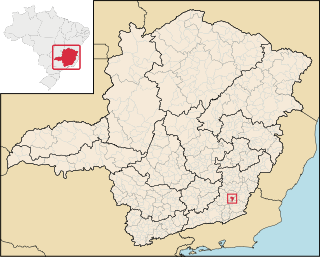
Guidoval is a Brazilian municipality located in the state of Minas Gerais. The city belongs to the mesoregion of Zona da Mata and to the microregion of Ubá.

The area around the campus of the Massachusetts Institute of Technology, or MIT, makes up Area 2 of Cambridge, Massachusetts. Area 2 is bounded by Main Street and Broadway on the north, the railroad tracks on the west, and the Charles River on the south and east. Its population in 2005 was 5,486 residents living in 794 households. The average household income was $37,287.

Mid-Cambridge, also known as "Area 6", is a neighborhood of Cambridge, Massachusetts. It is bounded by Massachusetts Avenue on the south and west, Prospect Street on the east, and Hampshire Street, the Somerville border, Kirkland Street, Quincy Street, and Cambridge Street on the north.

Riverside, also known as "Area 7", is a neighborhood of Cambridge, Massachusetts bounded by Massachusetts Avenue on the east, River Street on the south, the Charles River on the west, and JFK Street on the north. In 2005 it had a population of 11,201 residents in 3,341 households, and the average household income was $40,753.
Agassiz, also called Harvard North or "Area 8" or "Agassiz/Baldwin", is an unincorporated section of the city of Cambridge, Massachusetts, United States and as one of the thirteen sections (neighborhoods) that make up the City of Cambridge. Bounded by Massachusetts Avenue on the west, Cambridge Street, Quincy Street, and Kirkland Street on the south, Porter Square on the north, and the Somerville border on the northeast. It contains the Maria L. Baldwin Elementary School, formerly known as the Agassiz School.

West Cambridge, also known as "Area 10", is a neighborhood in Cambridge, Massachusetts. It is bounded by the Charles River on the south, JFK Street on the east, Concord Avenue on the north, and Fresh Pond, Aberdeen Avenue, and the Watertown line on the west.
North Cambridge, also known as "Area 11", is a neighborhood of Cambridge, Massachusetts bounded by Porter Square and the Fitchburg Line railroad tracks on the south, the city of Somerville on the northeast, Alewife Brook and the town of Arlington on the northwest, and the town of Belmont on the west. In 2005 it had a population of 10,642 residents living in 4,699 households, and the average income was $44,784. In 2010, the racial demographics for the neighborhood were 57.6% White, 20% Black, 15.1% Asian/Pacific Islander, 7.3% Hispanic origin, 0.3% Native American, 2.4% other race.
Sawins Pond is a man-made pond created in the 19th century in Watertown, Massachusetts, USA. Its banks were the site of an upscale hotel, and it was a popular fishing and swimming spot. It was then used by Hood Rubber company, and then BF Goodrich. They deposited scores of barrels onto the site, filled with rubber scraps.
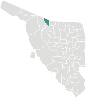
Sáric Municipality is a municipality in Sonora in north-western Mexico. Its northern boundary is the U.S. state of Arizona. The population of the municipality was 2,703 in 2010 living in an area of 1,676.23 square kilometers. The elevation is around 800 meters. At the municipal seat it is 780 meters.
