
Erosion is the action of surface processes that removes soil, rock, or dissolved material from one location on the Earth's crust and then transports it to another location where it is deposited. Erosion is distinct from weathering which involves no movement. Removal of rock or soil as clastic sediment is referred to as physical or mechanical erosion; this contrasts with chemical erosion, where soil or rock material is removed from an area by dissolution. Eroded sediment or solutes may be transported just a few millimetres, or for thousands of kilometres.

Rapids are sections of a river where the river bed has a relatively steep gradient, causing an increase in water velocity and turbulence. Flow, gradient, constriction, and obstacles are four factors that are needed for a rapid to be created.

Geomorphology is the scientific study of the origin and evolution of topographic and bathymetric features created by physical, chemical or biological processes operating at or near Earth's surface. Geomorphologists seek to understand why landscapes look the way they do, to understand landform and terrain history and dynamics and to predict changes through a combination of field observations, physical experiments and numerical modeling. Geomorphologists work within disciplines such as physical geography, geology, geodesy, engineering geology, archaeology, climatology, and geotechnical engineering. This broad base of interests contributes to many research styles and interests within the field.
Denudation is the geological processes in which moving water, ice, wind, and waves erode the Earth's surface, leading to a reduction in elevation and in relief of landforms and landscapes. Although the terms erosion and denudation are used interchangeably, erosion is the transport of soil and rocks from one location to another, and denudation is the sum of processes, including erosion, that result in the lowering of Earth's surface. Endogenous processes such as volcanoes, earthquakes, and tectonic uplift can expose continental crust to the exogenous processes of weathering, erosion, and mass wasting. The effects of denudation have been recorded for millennia but the mechanics behind it have been debated for the past 200 years and have only begun to be understood in the past few decades.

A meander is one of a series of regular sinuous curves in the channel of a river or other watercourse. It is produced as a watercourse erodes the sediments of an outer, concave bank and deposits sediments on an inner, convex bank which is typically a point bar. The result of this coupled erosion and sedimentation is the formation of a sinuous course as the channel migrates back and forth across the axis of a floodplain.

Plucking, also referred to as quarrying, is a glacial phenomenon that is responsible for the weathering and erosion of pieces of bedrock, especially large "joint blocks". This occurs in a type of glacier called a "valley glacier". As a glacier moves down a valley, friction causes the basal ice of the glacier to melt and infiltrate joints (cracks) in the bedrock. The freezing and thawing action of the ice enlarges, widens, or causes further cracks in the bedrock as it changes volume across the ice/water phase transition, gradually loosening the rock between the joints. This produces large pieces of rock called joint blocks. Eventually these joint blocks come loose and become trapped in the glacier.
In geomorphology, a knickpoint or nickpoint is part of a river or channel where there is a sharp change in channel slope, such as a waterfall or lake. Knickpoints reflect different conditions and processes on the river, often caused by previous erosion due to glaciation or variance in lithology. In the cycle of erosion model, knickpoints advance one cycle upstream, or inland, replacing an older cycle. A knickpoint that occurs at the head of a channel is called a headcut. Headcuts resulting in headward erosion are hallmarks of unstable expanding drainage features such as actively eroding gullies.

An hydrological transport model is a mathematical model used to simulate the flow of rivers, streams, groundwater movement or drainage front displacement, and calculate water quality parameters. These models generally came into use in the 1960s and 1970s when demand for numerical forecasting of water quality and drainage was driven by environmental legislation, and at a similar time widespread access to significant computer power became available. Much of the original model development took place in the United States and United Kingdom, but today these models are refined and used worldwide.

Sediment transport is the movement of solid particles (sediment), typically due to a combination of gravity acting on the sediment, and the movement of the fluid in which the sediment is entrained. Sediment transport occurs in natural systems where the particles are clastic rocks, mud, or clay; the fluid is air, water, or ice; and the force of gravity acts to move the particles along the sloping surface on which they are resting. Sediment transport due to fluid motion occurs in rivers, oceans, lakes, seas, and other bodies of water due to currents and tides. Transport is also caused by glaciers as they flow, and on terrestrial surfaces under the influence of wind. Sediment transport due only to gravity can occur on sloping surfaces in general, including hillslopes, scarps, cliffs, and the continental shelf—continental slope boundary.

Abrasion is a process of erosion which occurs when material being transported wears away at a surface over time. It is the process of friction caused by scuffing, scratching, wearing down, marring, and rubbing away of materials. The intensity of abrasion depends on the hardness, concentration, velocity and mass of the moving particles. Abrasion generally occurs in four ways: glaciation slowly grinds rocks picked up by ice against rock surfaces; solid objects transported in river channels make abrasive surface contact with the bed and walls; objects transported in waves breaking on coastlines; and by wind transporting sand or small stones against surface rocks.

The interaction between erosion and tectonics has been a topic of debate since the early 1990s. While the tectonic effects on surface processes such as erosion have long been recognized, the opposite has only recently been addressed. The primary questions surrounding this topic are what types of interactions exist between erosion and tectonics and what are the implications of these interactions. While this is still a matter of debate, one thing is clear, Earth's landscape is a product of two factors: tectonics, which can create topography and maintain relief through surface and rock uplift, and climate, which mediates the erosional processes that wear away upland areas over time. The interaction of these processes can form, modify, or destroy geomorphic features on Earth's surface.

In estimating erosion, Playfair's law is an empirical relationship that relates the size of a stream to the valley it runs through. It is better defined as a theory rather than law.

Stream power, originally derived by R. A. Bagnold in the 1960s, is the amount of energy the water in a river or stream is exerting on the sides and bottom of the river. Stream power is the result of multiplying the density of the water, the acceleration of the water due to gravity, the volume of water flowing through the river, and the slope of that water. There are many forms of the stream power formula with varying utilities, such as comparing rivers of various widths or quantifying the energy required to move sediment of a certain size. Stream power is closely related to other criteria such as stream competency and shear stress. Stream power is a valuable measurement for hydrologists and geomorphologists tackling sediment transport issues as well as for civil engineers, who use it in the planning and construction of roads, bridges, dams, and culverts.

A bedrock river is a river that has little to no alluvium mantling the bedrock over which it flows. However, most bedrock rivers are not pure forms; they are a combination of a bedrock channel and an alluvial channel. The way one can distinguish between bedrock rivers and alluvial rivers is through the extent of sediment cover.
In geology, degradation refers to the lowering of a fluvial surface, such as a stream bed or floodplain, through erosional processes. Degradation is the opposite of aggradation. Degradation is characteristic of channel networks in which either bedrock erosion is taking place, or in systems that are sediment-starved and are therefore entraining more material than they are depositing. When a stream degrades, it leaves behind a fluvial terrace. This can be further classified as a strath terrace—a bedrock terrace that may have a thin mantle of alluvium—if the river is incising through bedrock. These terraces may be dated with methods such as cosmogenic radionuclide dating, OSL dating, and paleomagnetic dating to find when a river was at a particular level and how quickly it is downcutting.
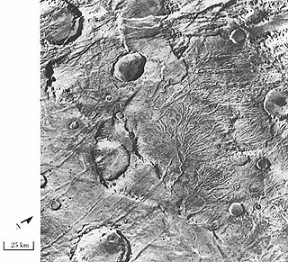
Valley networks are branching networks of valleys on Mars that superficially resemble terrestrial river drainage basins. They are found mainly incised into the terrain of the martian southern highlands, and are typically - though not always - of Noachian age. The individual valleys are typically less than 5 kilometers wide, though they may extend for up to hundreds or even thousands of kilometers across the martian surface.

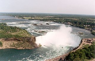
In Earth science, a pothole is a smooth, bowl-shaped or cylindrical hollow, generally deeper than wide, found carved into the rocky bed of a watercourse. Other names used for riverine potholes are pot, (stream) kettle, giant's kettle, evorsion, hollow, rock mill, churn hole, eddy mill, and kolk. Although somewhat related to a pothole in origin, a plunge pool is the deep depression in a stream bed at the base of a waterfall. It is created by the erosional forces of turbulence generated by water falling on rocks at a waterfall's base where the water impacts. Potholes are also sometimes referred to as swirlholes. This word was created to avoid confusion with an English term for a vertical or steeply inclined karstic shaft in limestone. However, given widespread usage of this term for a type of fluvial sculpted bedrock landform, pothole is preferred in usage to swirlhole.
Erodability is the inherent yielding or nonresistance of soils and rocks to erosion. A high erodability implies that the same amount of work exerted by the erosion processes leads to a larger removal of material. Because the mechanics behind erosion depend upon the competence and coherence of the material, erodability is treated in different ways depending on the type of surface that eroded.
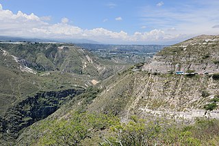
River incision is the narrow erosion caused by a river or stream that is far from its base level. River incision is common after tectonic uplift of the landscape. Incision by multiple rivers result in a dissected landscape, for example a dissected plateau. River incision is the natural process by which a river cuts downward into its bed, deepening the active channel. Though it is a natural process, it can be accelerated rapidly by human factors including land use changes such as timber harvest, mining, agriculture, and road and dam construction. The rate of incision is a function of basal shear-stress. Shear stress is increased by factors such as sediment in the water, which increase its density. Shear stress is proportional to water mass, gravity, and WSS:
Hillslope evolution is the changes in the erosion rates, erosion styles and form of slopes of hills and mountains over time.
