
Askham Richard is a village and civil parish in the unitary authority of City of York in the north of England, 6.5 miles (10.5 km) south-west of York, close to Copmanthorpe, Bilbrough and Askham Bryan. The population of the civil parish at the 2011 census was 351. The village became a Conservation Area in 1975. Nearby is Askham Bryan College of Agriculture.

Huntington is a village and civil parish in the unitary authority of City of York in North Yorkshire, England. It is part of the Huntington & New Earswick ward and lies on the River Foss, to the north of York and the south of Strensall.

Osbaldwick is a village and civil parish in the unitary authority of the City of York in North Yorkshire, England. The population of the civil parish as taken at the Census 2011 was 2,902. It has been in existence since at least the 11th century, and was declared a conservation area in 1978. It is the burial place of the nun Mary Ward.
Strensall is a village in the Strensall with Towthorpe civil parish in the unitary authority of the City of York in North Yorkshire, England, on the River Foss north of York and north-east of Haxby. From the 2011 Census, the civil parish of Strensall with Towthorpe and had a population of 6,047. It covers an area of 2,908 acres.

Dunnington is a village and civil parish in the City of York and ceremonial county of North Yorkshire, England. The population of the civil parish was 3,230 at the 2011 Census. The village is approximately 4 miles (6 km) east from York city centre.

Murton is a small village and a civil parish in the unitary authority of the City of York in North Yorkshire, England that is located on the outskirts of York. To the west there is the A64 and the village of Osbaldwick, to the south the A166 road to Bridlington, to the north the village of Stockton-on-the-Forest, and to the east the villages of Holtby and Warthill.

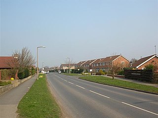
Stockton-on-the-Forest is a village and civil parish in the unitary authority of the City of York in North Yorkshire, England.

Earswick is a village and civil parish in the unitary authority of the City of York in North Yorkshire, England. It lies between Huntington and Strensall about 4 miles (6.4 km) north of York.

Towthorpe is a hamlet in Strensall with Towthorpe civil parish in the unitary authority of the City of York in North Yorkshire, England. It lies between Huntington and Strensall about 5 miles (8 km) north of York.

Rawcliffe is a village and civil parish in the unitary authority of the City of York in North Yorkshire, England. It is bordered by the A19 and A1237, and lies about 3 miles (4.8 km) north-west of York between Skelton and Clifton Without.
Hessay is a village and civil parish in the unitary authority area of the City of York, in the ceremonial county of North Yorkshire, England 4.7 miles (7.5 km) west of York.

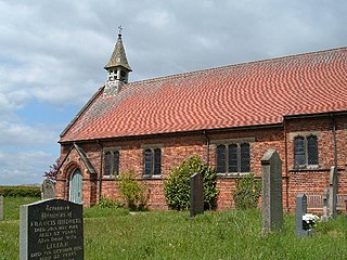
Holtby is a small village and civil parish in the unitary authority of the City of York in North Yorkshire, England. The population at the 2011 Census was 166. It lies close to the A166 about 5 miles (8 km) east of York.

Heworth Without is a civil parish and a ward in the City of York district, in the ceremonial county of North Yorkshire, England. Its boundary has changed over time. The ward is not coterminous with Heworth Without parish. While it consists today largely of those parts of Heworth that lay beyond the (pre-1996) city boundary, some areas such as Straylands Grove are within Heworth Without ward, but were also within the old city boundaries.

Deighton is a village and civil parish in the unitary authority of the City of York, North Yorkshire, England. The population of the civil parish as of the 2011 census was 291. It lies on the A19 about five miles south of York. According to the 2001 census the parish had a population of 308.

Kexby is a village and civil parish in the unitary authority of the City of York in North Yorkshire, England. It lies on the River Derwent and on the A1079 road about 5 miles (8 km) east of York not far from the East Riding of Yorkshire border.

Thorganby is a small village and civil parish in North Yorkshire, England. It was historically part of the East Riding of Yorkshire until 1974, but from 1974 to 2023 was in the Selby District of the shire county of North Yorkshire. In 2023 the district was abolished and North Yorkshire became a unitary authority.

Stillingfleet is a village and civil parish in North Yorkshire, England. It was in the historic East Riding of Yorkshire, but since 1974 has come under North Yorkshire. It is about 6 miles (10 km) south of York and nearby settlements include Acaster Selby, Naburn and Appleton Roebuck.
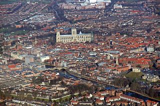
The City of York is a unitary authority area with city status in the ceremonial county of North Yorkshire, England. The district's main settlement is York, and it extends to the surrounding area including the town of Haxby and the villages of Earswick, Upper Poppleton, Nether Poppleton, Copmanthorpe, Bishopthorpe, Dunnington, Stockton on the Forest, Rufforth, Askham Bryan and Askham Richard, among other villages and hamlets. The unitary area had a population of 202,800 in the 2021 Census The City of York is administered by the City of York Council based in The Guildhall.

Lillings Ambo is a civil parish in North Yorkshire, England. It is between the villages of Strensall and Sheriff Hutton, and its southern edge is the border between the unitary authorities of North Yorkshire Council and the City of York Council. The River Foss flows through the parish, and in 2020, a scheme was approved to build a leaky dam to store water in the south of the parish in times of flood.


