The Moreau River is a tributary of the Missouri River, approximately 200 miles (320 km) long, in South Dakota in the United States. Moreau River has the name of a pioneer trader.

The Trinity River is a 710-mile-long (1,140 km) river in Texas, and is the longest river with a watershed entirely within the U.S. state of Texas. It rises in extreme northern Texas, a few miles south of the Red River. The headwaters are separated by the high bluffs on the southern side of the Red River.

The Newaukum River is a tributary of the Chehalis River in the U.S. state of Washington. It has three main branches, the North Fork, South Fork, and Middle Fork Newaukum Rivers. The length of the three forks and the mainstem river is 56.7 miles (91.2 km).

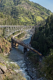
The Feather River is the principal tributary of the Sacramento River, in the Sacramento Valley of Northern California. The river's main stem is about 73 miles (117 km) long. Its length to its most distant headwater tributary is just over 210 miles (340 km). The main stem Feather River begins in Lake Oroville, where its four long tributary forks join together—the South Fork, Middle Fork, North Fork, and West Branch Feather Rivers. These and other tributaries drain part of the northern Sierra Nevada, and the extreme southern Cascades, as well as a small portion of the Sacramento Valley. The total drainage basin is about 6,200 square miles (16,000 km2), with approximately 3,604 square miles (9,330 km2) above Lake Oroville.

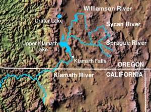
The Sprague River is a tributary of the Williamson River, approximately 75 miles (121 km) long, in southwestern Oregon in the United States. It drains an arid volcanic plateau region east of the Cascade Range in the watershed of the Klamath River.

The Yentna River is a river in South Central Alaska, formed by its East Fork and West Fork at 62°16′50″N151°46′26″W, flows South-East to Susitna River, 30 miles (48 km) North-West of Anchorage, Alaska; Cook Inlet Low.

The Shasta–Trinity National Forest is a federally designated forest in northern California, USA. It is the largest National Forest in California and is managed by the U.S. Forest Service. The 2,210,485 acre forest encompasses five wilderness areas, hundreds of mountain lakes and 6,278 miles (10,103 km) of streams and rivers. Major features include Shasta Lake, the largest man-made lake in California and Mount Shasta, elevation 14,179 feet (4,322 m).

The Nishnabotna River is a tributary of the Missouri River in southwestern Iowa, northwestern Missouri and southeastern Nebraska in the United States. It flows for most of its length as two parallel streams in Iowa, the East Nishnabotna River and the West Nishnabotna River. The east and west branches are each about 120 miles (190 km) long; from their confluence the Nishnabotna flows approximately another 16 miles (26 km).

The Klamath Basin is the region in the U.S. states of Oregon and California drained by the Klamath River. It contains most of Klamath County and parts of Lake and Jackson counties in Oregon, and parts of Del Norte, Humboldt, Modoc, Siskiyou, and Trinity counties in California. The 15,751-square-mile (40,790 km2) drainage basin is 35% in Oregon and 65% in California. In Oregon, the watershed typically lies east of the Cascade Range, while California contains most of the river's segment that passes through the mountains. In the Oregon-far northern California segment of the river, the watershed is semi-desert at lower elevations and dry alpine in the upper elevations. In the western part of the basin, in California, however, the climate is more of temperate rainforest, and the Trinity River watershed consists of a more typical alpine climate.
The Black Butte River is located in the Mendocino National Forest of northern California in Glenn and Mendocino counties. It is a tributary to the Middle Fork Eel River and flows northward for 24 miles (39 km) from its headwaters near Round Mountain to the confluence with the Middle Fork Eel River. The Northern California Coastal Wild Heritage Wilderness Act of 2006 added 21 miles (34 km) of the Black Butte River to the National Wild and Scenic Rivers System, of which 17.5 miles (28.2 km) are Wild status and 3.5 miles (5.6 km) are Scenic.

The Russian Wilderness is a wilderness area of 12,000 acres (49 km2) located approximately 65 miles (105 km) northeast of Eureka in northern California. It is within the Klamath National Forest in Siskiyou County and is managed by the US Forest Service. It was added to the National Wilderness Preservation System when the US Congress passed the California Wilderness Act of 1984.
The East Branch South Fork Eel River, a tributary of the South Fork Eel River, is formed by the confluence of Cruso Cabin Creek and Elkhorn Creek, in Mendocino County in the U.S. state of California. The river is roughly 25 miles (40 km) long, meandering west to its confluence with the South Fork Eel at Benbow Lake State Recreation Area. Major tributaries of the East Branch include Buck Mountain Creek, Squaw Creek, Rays Creek, and Tom Long Creek. The river flows west, turns north, and flows west again, through rugged terrain in the Coast Range of California. The East Branch is the South Fork Eel's largest tributary.
The Klamath River is a river in southern Oregon and northern California in the United States. This article describes its course.
The North Fork Trinity River is a tributary of the Trinity River in the U.S. state of California. It flows south through the Klamath Mountains for about 25 miles (40 km), emptying into the Trinity at Helena, about 5 miles (8.0 km) northeast of Junction City. The river drains an area of 151 square miles (390 km2). Important tributaries include the East Fork North Fork Trinity River and Grizzly Creek.

The Rice Fork is a 22.7-mile-long (36.5 km) tributary of the Eel River in Lake County, California. The Rice Fork begins on the upper northwest side of Goat Mountain, on the Colusa-Lake County line, at an elevation of over 6,000 feet (1,800 m). It quickly descends the steep western slope of the mountain, then bends northward, and flows northwesterly down a narrow winding steep walled canyon for about 18 miles (29 km), crossing two forest roads and adding many tributaries, ending its journey at the southern tip of Lake Pillsbury, at a varied elevation around 1,800 feet (550 m), depending on the lake level. Before the construction of Scott Dam in the 1920s, which formed Lake Pillsbury, the Rice Fork ran directly into the Eel River. It is one of Lake County's longest streams.

Cinnamon Lake is a census-designated place (CDP) within Jackson Township, Ashland County, Ohio, United States. The population was 1,243 at the 2010 census. It consists of a planned community surrounding a 135-acre (0.55 km2) reservoir also named Cinnamon Lake.

North Yolla Bolly Mountain is a 7,868-foot (2,398 m) peak in the Klamath Mountains of the Coast Ranges located in Trinity County, Northern California. The mountain is located in an isolated part of the Yolla Bolly-Middle Eel Wilderness, in the Shasta-Trinity National Forest, about 50 miles (80 km) west of Red Bluff. It is situated about 13 miles (21 km) from Mount Linn, the highest point of the Coast Ranges south of the Trinity Alps.
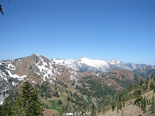
The South Fork Salmon River is a 39.5-mile (63.6 km) river in Siskiyou County, California and is the larger of two tributaries that join to form the Salmon River, the other being the North Fork. It begins in the Trinity Alps, on the border of Siskiyou and Trinity County, about 15 miles (24 km) north of Weaverville, and flows generally northwest through the Salmon Mountains to its confluence with the North Fork at Forks of Salmon. The South Fork drains an area of 290 square miles (750 km2), located entirely in the Klamath National Forest, with a significant portion in the Trinity Alps Wilderness.


