Stubbs Wood Country Park

Last updated

Stubbs Wood Country Park
Bench on the Greensand Way in Stubbs Wood - geograph.org.uk - 1549170.jpg
Stubbs Wood Bench looking towards Bough Beech Reservoir
Kent UK location map.svg
Red pog.svg
Stubbs Wood Country Park shown within Kent
OS grid TQ496518
Coordinates 51°14′30″N0°08′41″E / 51.2416°N 0.1448°E / 51.2416; 0.1448
Area102.172 hectares (252.47 acres)
Operated by Sundridge with Ide Hill Parish Council,
Open7 days a week, dawn until dusk
Website Official website

Stubbs Wood Country Park is in Sevenoaks, in Kent, England. It is located on the Greensand Ridge, close to Ide Hill village. The site is owned and managed by Sundridge with Ide Hill Parish Council. [1]

Contents

History

In 1769, it was part of Whitley Forest, which has remained largely intact [2] due to the varied geology and poor soil types on the Greensand escarpment, which are unsuitable for intensive farming. [3]

The forest is a Site of Special Scientific Interest as part of the larger Scords Wood and Brockhoult Mount area (which includes Toys Hill). The ancient forest is home to some plants that are scarce in Kent. [4]

The forest suffered badly in the Great Storm of 1987. Replanting was partly funded by the Ide Hill Society with monies given to the National Trust and Kent County Council. [5] Some huge ancient oak and beech trees survived the gales. Holly, whitebeam, ash, chestnut, hazel and rowan trees are present. Bluebells carpet the ground in the spring. [6]

Ownership

On April 4, 2014 Stubbs Wood was put up for sale by Kent County Council, [5] which announced a three-week consultation period. With the intention of keeping public ownership of the woods, a campaign was started.[ citation needed ] The woodland, which is part of a Site of Special Scientific Interest and also part of the Green Belt, has a number of restrictive covenants which limit its potential future use,[ citation needed ] it also includes a network of public footpaths, which needed to be retained.[ citation needed ] Sundridge with Ide Hill Parish Council took over the ownership and management of the site in 2015. [1]

Hanging Bank

Hanging Bank Information Board Hanging Bank Information Board - geograph.org.uk - 1549330.jpg
Hanging Bank Information Board

A part of the forest near to Ide Hill is known as Hanging Bank. On 28 January 1554, during Wyatt's rebellion against Queen Mary, a rebel force of about 500 men led by Henry Isley clashed with a similar-sized loyal force led by Lord Abergavenny and Sir Robert Southwell, at Wrotham Hill. After a running battle over about 4 miles (6 km), the rebels made their last stand at Hartley Wood, where they were defeated. A gallows was set up in the wood and many people were hanged. [7]

Lady Amherst's Drive

Sarah Amherst was the first wife of William Amherst, 1st Earl Amherst, who was Governor-General of India from 1823 to 1828. Born William Pitt Amherst, he inherited the Montreal estate on the outskirts of nearby Sevenoaks from his great uncle Jeffrey Amherst, 1st Baron Amherst, who commanded the British forces in Canada who took Quebec (under General Wolfe) and Montreal – hence the name of his estate. While the estate house was long ago demolished, Wolf’s own Quebec House in nearby Westerham is now under the management of the National Trust. The Amhersts were responsible for introducing the Asian game bird known as Lady Amherst's pheasant to Bedfordshire. Lady Amherst was fond of a drive along the Greensand Ridge through Stubbs Wood with its panoramic views of Kent. [8]

The drive follows the line of the ancient road, the route from Bessels Green (near Sevenoaks) and Sundridge leading through Whitley Forest to Ide Hill. In the late 18th century, this track was re-routed via Goathurst Common and made into a road. [9]

Stubbs Wood Track Track from Quarry Cottage towards Ide Hill - geograph.org.uk - 1549272.jpg
Stubbs Wood Track

Greensand Way

Lady Amherst's Drive (now a track) remains as the footpath through Stubbs Wood from Sevenoaks Weald to Ide Hill. [10] [11] Walk 6 in Walking in Kent (Ide Hill to Manor Farm and then back to Ide Hill) follows the route through the wood. [12]

Parts of the forest are accessible via horseback and bicycle on the public bridleways. Some of the paths at the top of the greensand ridge are suitable for people with walking difficulties, but others (near the Hanging Bank) are very steep. [6]

Related Research Articles

<span class="mw-page-title-main">Sevenoaks</span> Market town and civil parish in western Kent, England

Sevenoaks is a town in Kent with a population of 29,506 situated south-east of London, England. Also classified as a civil parish, Sevenoaks is served by a commuter main line railway into London. Sevenoaks is 21 miles (34 km) from Charing Cross, the traditional centre of London. It is the principal town of the Sevenoaks district, followed by Swanley and Edenbridge.

<span class="mw-page-title-main">Ide Hill</span> Human settlement in England

Ide Hill is a village within the civil parish of Sundridge with Ide Hill, in the Sevenoaks District of Kent, England. It stands on one of the highest points of the Greensand Ridge about three miles south-west of Sevenoaks. Its name first appears on record in 1250 as Edythehelle. It is an eponymic denoting 'Edith's hill', from the Old English hyll 'hill'. The village lies within the Kent Downs Area of Outstanding Natural Beauty.

<span class="mw-page-title-main">Kent Downs</span> Area of Outstanding Natural Beauty in Kent, England

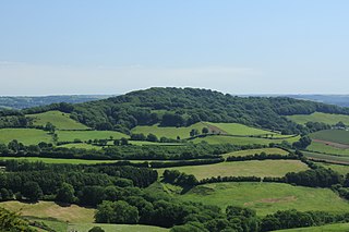
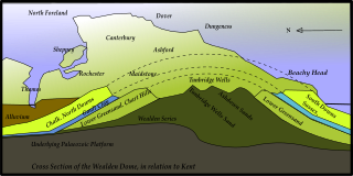
The Kent Downs is an Area of Outstanding Natural Beauty (AONB) in Kent, England. They are the eastern half of the North Downs and stretch from the London/Surrey borders to the White Cliffs of Dover, including a small section of the London Borough of Bromley. The AONB also includes the Greensand Ridge, a prominent sandstone escarpment which lies south of the chalk escarpment of the North Downs.

<span class="mw-page-title-main">Sevenoaks (UK Parliament constituency)</span>

Sevenoaks is a constituency represented in the House of Commons of the UK Parliament since 2019 by Laura Trott, a Conservative.

<span class="mw-page-title-main">Lewesdon Hill</span> Hill and hill fort in south west Dorset, England

Lewesdon Hill is a hill in west Dorset, England. With a maximum elevation of 279 m (915 ft), it is the highest point in Dorset.

<span class="mw-page-title-main">Surrey Hills AONB</span>

The Surrey Hills is a 422 km2 (163 sq mi) Area of Outstanding Natural Beauty (AONB), which principally covers parts of the North Downs and Greensand Ridge in Surrey, England. The AONB was designated in May 1958 and adjoins the Kent Downs AONB to the east and the South Downs National Park in the south west.

<span class="mw-page-title-main">Greensand Way</span>

The Greensand Way is a long-distance path of 108 miles (174 km) in southeast England, from Haslemere in Surrey to Hamstreet in Kent. It follows the Greensand Ridge along the Surrey Hills and Chart Hills. The route is mostly rural, passing through woods, and alongside fruit orchards and hop farms in Kent and links with the Stour Valley Walk near Pluckley in Kent. The trail was opened on 15 June 1980 and is jointly managed by Surrey and Kent Councils who fully updated it in 2012.

<span class="mw-page-title-main">Sundridge, Kent</span> Human settlement in England

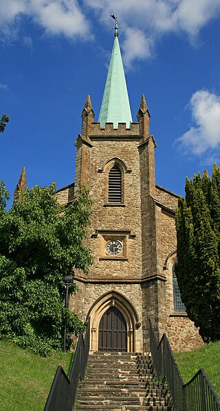
Sundridge is a village within the civil parish of Sundridge with Ide Hill, in the Sevenoaks district of Kent, England. The village is located on the A25 road to the east of Westerham. It lies within the Kent Downs Area of Outstanding Natural Beauty and within London’s Metropolitan Green Belt. It is approximately 21 miles south of London. Its church is Anglican and dedicated to St Mary.

<span class="mw-page-title-main">Toys Hill</span> Human settlement in England

Toys Hill is a hamlet which lies within Brasted civil parish in the Sevenoaks district of Kent, England. It lies to the south of Brasted Chart, also in the parish.

<span class="mw-page-title-main">Sundridge with Ide Hill</span> Human settlement in England

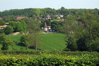
Sundridge and Ide Hill is a civil parish in the Sevenoaks District of Kent, England. It is located in the Darenth valley and lies between Sevenoaks and Westerham. The parish contains the villages of Sundridge and Ide Hill and the hamlet of Goathurst Common. It lies within the Kent Downs Area of Outstanding Natural Beauty and within London’s Metropolitan Green Belt. It is approximately 21 miles south of London.

<span class="mw-page-title-main">Riverhead, Kent</span> Human settlement in England

Riverhead is a northern village part of the urban area of Sevenoaks in the district of the same name in Kent, England and is also a civil parish. The parish had a population in 2001 of 1821, increasing to 2,634 at the 2011 Census.

<span class="mw-page-title-main">Greensand Ridge</span> Range of hills in south east England, UK

The Greensand Ridge, also known as the Wealden Greensand is an extensive, prominent, often wooded, mixed greensand/sandstone escarpment in south-east England. Forming part of the Weald, a former dense forest in Sussex, Surrey and Kent, it runs to and from the East Sussex coast, wrapping around the High Weald and Low Weald. It reaches its highest elevation, 294 metres (965 ft), at Leith Hill in Surrey—the second highest point in south-east England, while another hill in its range, Blackdown, is the highest point in Sussex at 280 metres (919 ft). The eastern end of the ridge forms the northern boundary of Romney Marsh.

<span class="mw-page-title-main">Geography of Kent</span> Overview of the geography of Kent

Kent is the south-easternmost county in England. It is bounded on the north by the River Thames and the North Sea, and on the south by the Straits of Dover and the English Channel. The continent of Europe is 21 miles across the straits.

Bessels Green is a village now incorporated into the built-up area of Sevenoaks in Kent, England. It is on the north-western outskirts of Sevenoaks, in the parish of Chevening. At the 2011 Census the village population was included in the civil parish of Sundridge with Ide Hill. The busy trunk route of the A25 runs through the centre of the village.

Dryhill is a small hamlet in the Sevenoaks district, in the county of Kent, England.

<span class="mw-page-title-main">Radnor House Sevenoaks School</span> Co-ed independent school in Kent, England (UK)

Radnor House Sevenoaks School is a coeducational private day school located in Sundridge in the English county of Kent.

The geology of Kent in southeast England largely consists of a succession of northward dipping late Mesozoic and Cenozoic sedimentary rocks overlain by a suite of unconsolidated deposits of more recent origin.

The 2015 Sevenoaks District Council election took place on 7 May 2015 to elect members of the Sevenoaks District Council in England. It was held on the same day as other local elections.

Sevenoaks District Council is the local authority for the Sevenoaks District in Kent, England. The council is elected every four years.

References

  1. 1 2 Morris, Thom (16 March 2015). "Stubbs Wood to be run by Sundridge with Ide Hill Parish Council" . Retrieved 15 December 2018.
  2. "IDE HILL Conservation Area Appraisal SUPPLEMENTARY PLANNING GUIDANCE" (PDF). www.sevenoaks.gov.uk. December 2003. Archived from the original (PDF) on 14 October 2013. Retrieved 19 November 2013.
  3. "Teachers Guide: Landscape Features" (PDF). Kent Downs Area of Outstanding Natural Beauty Landscape Education Project. Retrieved 19 November 2013.
  4. "SSSI name: Scord's Wood and Brockhoult Mount" (PDF). www.sssi.naturalengland.org.uk. 1963. Retrieved 19 November 2013.
  5. 1 2 "Anger at council's plans to sell off popular Ide Hill wood". Sevenoaks Chronicle. 10 April 2014. Retrieved 28 April 2014.
  6. 1 2 "Stubbs Wood". www.kent.gov.uk. Archived from the original on 27 March 2013. Retrieved 19 November 2013.
  7. "Greensand circular taster" (PDF). www.kent.gov.uk. Retrieved 19 November 2013.
  8. "Kent Walks No.60". www.kentramblers.org.uk. Retrieved 19 November 2013.
  9. "From the 'great jackal hunt' to the Great Storm carnage". www.thisiskent.co.uk. 14 December 2012. Retrieved 19 November 2013.
  10. "GREENSAND WAY - Part 4 One Tree Hill (Nr Sevenoaks) to Oxted". www.bertuchi.co.uk. 11 July 2010. Retrieved 19 November 2013.
  11. "Greensand Guide" (PDF). www.kent.gov.uk. Retrieved 19 November 2013.
  12. Reynolds, Kev (1 March 2007). Walking in Kent: 40 Walks Throughout the County (Cicerone Guide) 2nd Revised edition. Cicerone Press. ISBN   978-1852844622.