Environment and Climate Change Canada, is the department of the Government of Canada responsible for coordinating environmental policies and programs, as well as preserving and enhancing the natural environment and renewable resources. It is also colloquially known by its former name, Environment Canada.

Ovintiv Inc. is a hydrocarbon exploration and production company organized in Delaware and headquartered in Denver, United States. It was founded and headquartered in Calgary, Alberta, under its previous name Encana. It was the largest energy company and largest natural gas producer in Canada, before moving to the United States in 2020. The company was rebranded as Ovintiv and relocated to Denver in 2019–20.

The British Army Training Unit Suffield (BATUS) is a British Army unit located at the vast training area of Canadian Forces Base Suffield near Suffield, Alberta, Canada. BATUS is the British Army's largest armoured training facility, and it can accommodate live-firing and tactical effect simulation (TES) exercises up to battle group level. CFB Suffield is seven times the size of Salisbury Plain Training Area and 19% the size of Northern Ireland, offering the British Army the ability to conduct large exercises that UK military bases cannot accommodate.
Defence Research and Development Canada is the science and technology organization of the Department of National Defence (DND), whose purpose is to provide the Canadian Armed Forces (CAF), other government departments, and public safety and national security communities with knowledge and technology.

Canadian Forces Base Suffield is a Canadian Forces base, host to the largest military training area in Canada. It is located in southeastern Alberta, 3 nautical miles north-northwest of Suffield, 50 km (31 mi) northwest of the city of Medicine Hat and 250 km (160 mi) southeast of Calgary. It is accessible via Highway 884, a public road that bisects the main hub section of the base.

The Baca National Wildlife Refuge is a 78,697-acre (31,848 ha) United States National Wildlife Refuge located in southern Colorado. It is within the Sangre de Cristo National Heritage Area.

The Sierra Club Canada Foundation (SCCF) is a Canadian environmental organization made up of a national branch and five chapters in Ontario, Atlantic Canada, Québec, the Prairies, and a nation-wide Youth chapter. The organization's mission is to 'empower people to be leaders in protecting, restoring and enjoying healthy and safe ecosystems.'

Canadian Forces Base Cold Lake, abbreviated as CFB Cold Lake, is a Canadian Forces Base in the City of Cold Lake, Alberta.
The Western Canadian Sedimentary Basin (WCSB) underlies 1.4 million square kilometres (540,000 sq mi) of Western Canada including southwestern Manitoba, southern Saskatchewan, Alberta, northeastern British Columbia and the southwest corner of the Northwest Territories. This vast sedimentary basin consists of a massive wedge of sedimentary rock extending from the Rocky Mountains in the west to the Canadian Shield in the east. This wedge is about 6 kilometres (3.7 mi) thick under the Rocky Mountains, but thins to zero at its eastern margins. The WCSB contains one of the world's largest reserves of petroleum and natural gas and supplies much of the North American market, producing more than 450 million cubic metres per day of gas in 2000. It also has huge reserves of coal. Of the provinces and territories within the WCSB, Alberta has most of the oil and gas reserves and almost all of the oil sands.

Canada's early petroleum discoveries took place near population centres or along lines of penetration into the frontier.
The Defence Research Establishment Suffield was the name of the military research facility located 5 km (3.1 mi) north of Suffield, Alberta, from 1967 to its renaming to DRDC Suffield in 2000.

The following outline is provided as an overview of and topical guide to British Columbia:
The Crown Village of Ralston is east of Highway 884 on CFB Suffield within Cypress County in southern Alberta, Canada. It is approximately 3 km (1.9 mi) north of the Hamlet of Suffield and the Trans-Canada Highway.
The Suffield Block is an area located within Cypress County, southern Alberta, Canada approximately bounded by Highway 884 on the west, Highway 555 on the north, the South Saskatchewan River on the east and the Trans-Canada Highway on the south. The Suffield Block is managed by CFB Suffield.
DRDC Suffield is a major Canadian military research facility located 5 km (3.1 mi) north of Suffield, Alberta, and is one of eight centres making up Defence Research and Development Canada (DRDC).
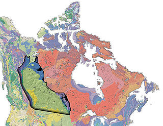
Wawaskesy National Park was created north and west of the South Saskatchewan River, north of the city of Medicine Hat in southeastern Alberta, Canada, on May 31, 1922. It was closed on June 24, 1938, and delisted in 1947.
The Biological and Chemical Defence Review Committee, or BCDRC is a civilian body having oversight of the Canadian military's activities in the area of defence against biological and chemical warfare.

The Coastal GasLink pipeline is a TC Energy natural gas pipeline under construction in British Columbia, Canada. Starting in Dawson Creek, the pipeline's route crosses through the Canadian Rockies and other mountain ranges to Kitimat, where the gas will be exported to Asian customers. Its route passes through several First Nations peoples' traditional lands, including some that are unceded. Controversy around the project has highlighted important divisions within the leadership structure of impacted First Nations: elected band councils established by the 1876 Indian Act support the project, but traditional hereditary chiefs of the Wetʼsuwetʼen people oppose the project on ecological grounds and organized blockades to obstruct construction on their traditional land.
