Hoy is an island in Orkney, Scotland, measuring 143 square kilometres (55 sq mi) – the second largest in the archipelago, after Mainland. A natural causeway, the Ayre, links the island to the smaller South Walls; the two islands are treated as one entity by the UK census. Hoy is also the name of a hamlet in the northwest of the island.

The Small Isles are a small archipelago in the Inner Hebrides, off the west coast of Scotland. They lie south of Skye and north of Mull and Ardnamurchan – the most westerly point of mainland Scotland.

The northern gannet is a seabird, the largest species of the gannet family, Sulidae. It is native to the coasts of the Atlantic Ocean, breeding in Western Europe and Northeastern North America. It is the largest seabird in the northern Atlantic. The sexes are similar in appearance. The adult northern gannet has a mainly white streamlined body with a long neck, and long and slender wings. It is 87–100 cm long with a 170–180 cm (67–71 in) wingspan. The head and nape have a buff tinge that is more prominent in breeding season, and the wings are edged with dark brown-black feathers. The long, pointed bill is blue-grey, contrasting with black, bare skin around the mouth and eyes. Juveniles are mostly grey-brown, becoming increasingly white in the five years it takes them to reach maturity.

Rona is an uninhabited Scottish island in the North Atlantic. It is often referred to as North Rona to distinguish it from the island of South Rona in the Inner Hebrides. It has an area of 109 hectares and a maximum elevation of 108 metres (354 ft).

The Mainland, also known as Hrossey and Pomona, is the main island of Orkney, Scotland. Both of Orkney's burghs, Kirkwall and Stromness, lie on the island, which is also the heart of Orkney's ferry and air connections.

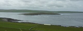
North Ronaldsay is the northernmost island in the Orkney archipelago of Scotland. With an area of 690 hectares (2.7 sq mi), it is the fourteenth-largest. It is mentioned in the Orkneyinga saga; in modern times it is known for its historic lighthouse, migratory bird life and unusual breed of sheep.

The Northern Isles are a chain of islands of Scotland, located off the north coast of the Scottish mainland. The climate is cool and temperate and highly influenced by the surrounding seas. There are two main island groups: Shetland and Orkney. There are a total of 36 inhabited islands, with the fertile agricultural islands of Orkney contrasting with the more rugged Shetland islands to the north, where the economy is more dependent on fishing and the oil wealth of the surrounding seas. Both archipelagos have a developing renewable energy industry. They share a common Pictish and Norse history, and were part of the Kingdom of Norway before being absorbed into the Kingdom of Scotland in the 15th century. The islands played a significant naval role during the world wars of the 20th century.
The Out Skerries are an archipelago of islets, some inhabited, in Shetland, Scotland, and are the easternmost part of Shetland. Locally, they are usually called Da Skerries or just Skerries.
Eynhallow is a small, presently uninhabited island in Eynhallow Sound, between Rousay and the Mainland of Orkney, off the north coast of mainland Scotland. It is 75 hectares in area. There is an unnamed skerry about 100 metres to the north-east of the island, separated by Fint Sound. Sheep Skerry adjoins the southern end of the island.
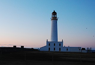
Auskerry is a small island in eastern Orkney, Scotland. It lies in the North Sea south of Stronsay and has a lighthouse, completed in 1866.

Sule Skerry is a remote skerry in the North Atlantic off the north coast of Scotland.

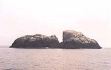
Sula Sgeir is a small, uninhabited Scottish islet in the North Atlantic, 18 kilometres west of Rona. One of the most remote islands of the British Isles, it lies approximately forty nautical miles north of Lewis and is best known for its population of gannets. It has a narrow elongated shape running north-northeast to south-southwest, and is approximately 900 m long by typically 100 m wide.

The Islands of the Forth are a group of small islands located in the Firth of Forth and in the estuary of the River Forth on the east coast of Scotland. Most of the group lie in the open waters of the firth, between the Lothians and Fife, with the majority to the east of the city of Edinburgh. Two islands lie further west in the river estuary.
Stuley is an island lying to the east of South Uist in the Outer Hebrides, Scotland. It lies off the section of coastline between Loch Eynort and Loch Boisdale. It is 45 hectares (0.17 sq mi) and 40 metres (131 ft) at its highest point.

St Magnus Bay is a large coastal feature in the north-west of Mainland Shetland, Scotland. Roughly circular in shape with a diameter of about 19 kilometres (12 mi), it is open to the North Atlantic Ocean to the west. The indented coastline to the north, south and east between Esha Ness in the north and the Ness of Melby in the south contains numerous bays, firths and voes and there are several islands around the perimeter. The waters of the bay are up to 165 metres (541 ft) deep and may have been the site of a substantial meteor impact.