Chimbote ; Quechua: Chimputi) is the largest city in the Ancash Region of Peru, and the capital of both Santa Province and Chimbote District.

Moyobamba or Muyupampa is the capital city of the San Martín Region in northern Peru. Called "Santiago of eight valleys of Moyobamba" or "Maynas capital". There are 50,073 inhabitants, according to the 2017 census. Some 3,500 species of orchids are native to the area, which has led to the city's nickname of The City of Orchids. The city is the capital of both Moyobamba Province and Moyobamba District.

Pisco is a city located in the Department of Ica of Peru, the capital of the Pisco Province. The city is around 9 metres above sea level. Pisco was founded in 1640, close to the indigenous emplacement of the same name. Pisco originally prospered because of its nearby vineyards and became noted for its grape brandy or pisco which was exported from its port. Pisco has an estimated population of 104,656.

Piura is a city in northwestern Peru located north of the Sechura Desert on the Piura River. It is the capital of the Piura Region and the Piura Province. Its population was 484,475 as of 2017 and is the 7th most populous city in Peru. The city is located in the central eastern part of the Piura Region, 981 kilometers from the countrys capital, Lima and is near to the border with Ecuador.

Puno is a city in southeastern Peru, located on the shore of Lake Titicaca. It is the capital city of the Puno Region and the Puno Province with a population of approximately 140,839. The city was established in 1668 by viceroy Pedro Antonio Fernández de Castro as capital of the province of Paucarcolla with the name San Juan Bautista de Puno. The name was later changed to San Carlos de Puno, in honor of king Charles II of Spain. Puno has several churches dating back from the colonial period; they were built to service the Spanish population and evangelize the Quechua people.
Piura is a coastal department and region in northwestern Peru. The region's capital is Piura and its largest port cities, Paita and Talara, are also among the most important in Peru. The area is known for its tropical and dry beaches. It is the most populous department in Peru, its twelfth smallest department, and its fourth-most densely populated department, after Tumbes, La Libertad, and Lambayeque.

San Vicente de Cañete, commonly known as San Vicente or Cañete, is a city and capital of the Cañete Province, in southern Lima Region. With a population of 85,533.

Lambayeque is a city on the coast of northern Peru and capital of the homonymous district and province in the department of Lambayeque. It is located 4.7 km from the city of Chiclayo and 13 km from the Pacific Ocean. It is an important cultural and educational center of the department as it houses some of the most important museums in the country, such as the Royal Tombs Museum and the Brüning Museum. It was founded in 1553 under the name of San Pedro de Lambayeque by order of the Viceroy Conde de Nieva.

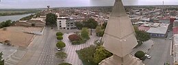
Sechura is a town in northwestern Peru, 50 km (31 mi) south of Piura. It is the capital of Sechura Province in the Piura Region. The city lends its name to the Sechura Desert, which extends south along most of coastal Peru. Crescent dunes lie south of the city, between the sea and the highway.

Paita is a city in northwestern Peru. It is the capital of the Paita Province which is in the Piura Region. It is a leading seaport in the region. Paita is located 1,089 km northwest of the country's capital Lima, and 57 km northwest of the regional capital of Piura. Starting in 2014, the city has considered ideas for separating from the Piura Region, proclaiming itself as the "Miguel Grau Region".
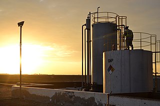
Talara is a city in the Talara Province of the Piura Region, in northwestern Peru. It is a port city on the Pacific Ocean with a population of 91,444 as of 2017. Its climate is hot and dry. Due to its oil reserves, and ability to produce aviation fuel, Talara hosted a United States air base during World War II. It was also one of two refueling stations for the Pacific Fleet. There were naval guns on the hills, and submarine nets in the harbor. The Ajax, Achilles and Exeter, three British destroyers, were refuelled there on their way around the Horn to catch the Graf Spee in Rio de la Plata. Talara is also home to a large fishing fleet. The city is served by the Cap. FAP Víctor Montes Arias Airport.
Rioja is the capital of Rioja Province in the San Martín Region in northern Peru. It is situated to the west of Moyobamba. There are 24,263 inhabitants according to the 2007 census.

Yurimaguas is a port town in the Loreto Region of the northeastern Peruvian Amazon. Historically associated with the Mainas missions, the culturally diverse town is affectionately known as the "Pearl of the Huallaga". Yurimaguas is located at the confluence of the majestic Huallaga and Paranapura Rivers in the steamy rainforests of northeastern Peru. It is the capital of both Alto Amazonas Province and Yurimaguas District, and had a population estimated at about 62,903 inhabitants (2017).

Chulucanas is a town in Morropón Province, Piura Region, Peru. It lies in the Piura Valley just north of the confluence of the Charanal River with the Piura River. Chulucanas is the administrative seat for both Chulucanas District and Morropón Province.

Catacaos is a town in the Piura Province, Piura Region, Peru. It is known for its gastronomy and crafts.

Huamachuco is a town in northern Peru and capital of the province Sánchez Carrión in La Libertad Region. The city is the seat of the Territorial Prelature of Huamachuco. Lake Sausacocha lies to the northeast.
Ignacio Escudero District is one of eight districts of the province Sullana in Peru, part of the region of Piura.

Chepén is a city of La Libertad Region and capital of the Chepén Province, in Peru. The city is a rice production center with the valleys of Chepén and Jequetepeque, and has an active trading with neighboring Guadalupe, Pacasmayo and San Pedro de Lloc and other towns. It has factories in industrial dyes, food and primary production.

Moche is a Peruvian city, the capital of Moche District in Trujillo Province of La Libertad Region in northern Peru. It is located in the Moche Valley and was the center of development of the ancient Moche or Mochica culture. Now it is a major tourist destination of the Moche Route tourist circuit and It is part of the integrated area of Trujillo city.

Ilave, also known as Illawi, is the capital city of the Ilave District in El Collao Province, in the Puno Region of Peru. According to the projection of the 2012 census, it has 57,366 inhabitants. It is located on the Ilave River and west from Lake Titicaca.