Sulphur Springs, Benton County, Arkansas

Last updated

Sulphur Springs, Arkansas
Benton County Arkansas Incorporated and Unincorporated areas Sulphur Springs Highlighted 0567760.svg
Location of Sulphur Springs in Benton County, Arkansas.
Coordinates: 36°29′01″N94°27′33″W / 36.48361°N 94.45917°W / 36.48361; -94.45917
Country United States
State Arkansas
County Benton
Area
[1]
  Total1.01 sq mi (2.63 km2)
  Land1.01 sq mi (2.62 km2)
  Water0.00 sq mi (0.01 km2)
Elevation
[2]
909 ft (277 m)
Population
 (2020)
  Total481
  Density475.77/sq mi (183.78/km2)
Time zone UTC-6 (Central (CST))
  Summer (DST) UTC-5 (CDT)
ZIP code
72768
Area code 479
FIPS code 05-67760
GNIS feature ID2405541 [2]

Sulphur Springs is a city in Benton County, Arkansas, United States. The population was 481 at the 2020 census. [3] It is part of the Northwest Arkansas region.

Contents

History

Sulphur Springs got its start in 1885 as a mineral spa resort. [4]

Geography

Sulphur Springs is located in northwest Benton County. The city center is about one mile south of the Missouri-Arkansas state line. Arkansas Highway 59 runs through the city, leading north to Noel, Missouri, and south to Gravette. [5] According to the United States Census Bureau, the city has a total area of 1.0 square mile (2.6 km2), all land. [3]

Sulphur Springs is in the Springfield Plateau subregion of the Ozarks. It has porous rocks through which rain easily can pass underground to the aquifers. When water in aquifers flow down a hillside, or are pushed up to the surface, this causes a spring. The springs in Sulphur Springs are exceptionally rich in several minerals, and historically the springs were labeled to indicate the purported mineral found in each: [6] [7]

Ozark Colony

Ozark Colony was originally a nearby community, but now is a Sulphur Springs neighborhood. In 1921, Walter R. Eaton, a retired oilman, established the colony with $25,000 capital [8] (equivalent to about $436,200 in 2024) as an intellectual and artistic recreation-based cooperative: people would buy a plot of land and agree to work in community-held ventures with the proceeds going toward their vacation expenses in the colony. People worked in the 100-acre (40.4 ha) vineyard that was owned collectively under the name Ozark Colony Grape Club, and processed the grapes into juice and marmalade to sell. [9] They also made hickory furniture and had a poultry club. [10] Eaton, as president of the Ozark League Commission, also collaborated with neighboring tourist towns such as Eureka Springs to promote and market the home products and handicrafts made at the colony. [11]

Artist Jim Sease carving totem pole for Ozark Colony Jim A. Sease.png
Artist Jim Sease carving totem pole for Ozark Colony

The colony had more than 40 cottages, a Grecian theater with classical recitals and costumed performers, [12] [13] a lodge with a dance floor and disco ball, [14] manmade lakes stocked with trout for fishing, tennis courts, and a swimming pool. [15] [16] Seasonally, they had artist exhibits, art classes with visiting directors from the Kansas City Art Institute, [17] music classes, and plays. [10]

Artist, cabinet-maker, and resident Jim Sease made a totem pole [18] (which were fashionable in tourist and resort areas at the time), telling the community's history, from a generalized nod to native Americans, to the four springs for which Sulphur Springs is named, then the railroad and airplanes, and a modern city with resort hotels and John Brown University. [19] [note 1]

Painter John Eliot Jenkins kept a studio in the colony. His paintings are now in state capitols and libraries in Kansas, Missouri, Oklahoma, Texas, and Virginia, [20] and his Snow in the Ozarks (1925) oil on canvas painting is part of the Foundation Collection at the Arkansas Museum of Fine Arts in Little Rock, Arkansas. [21]

Demographics

Historical population
CensusPop.Note
1900 315
1910 50058.7%
1920 470−6.0%
1930 404−14.0%
1940 4357.7%
1950 54324.8%
1960 460−15.3%
1970 5039.3%
1980 496−1.4%
1990 5235.4%
2000 67128.3%
2010 511−23.8%
2020 481−5.9%
U.S. Decennial Census [22]

At the 2020 census, [23] 481 people lived in Sulphur Springs. There were 193 households. The median age was 34.5 years old.

Income and poverty: Median income was $36.691; 17.2% experiencing poverty.

Education: 47% high school or equivalent degree; 11% some college, no degree; 4.6% Associates degree; 10.4% Bachelor's degree; 3.7% Graduate or professional degree.

Employment: 70.2% employees of private companies; 19.5% local, state, and federal workers; 10.2% self-employed.

Average travel time to work: 24.3 minutes; 65.9% drive alone to work; 27.3% carpool to work; 6.3% work from home.

Health: 28.6% without health care coverage; 21.5% have one or more disabilities.

Living arrangements: 46.1% married couple household; 29% male householder with no spouse present; 17.1% female householder with no spouse present.

Race and ethnicity: 390 people white alone; 68 two or more races; 55 some other race than the options given; 16 Hispanic or Latino of any race; 7 Native Hawaiian or Pacific Islander; 5 American Indian and Alaska native alone; 4 Black alone; 2 Asian alone.

Education

It is in the Gravette School District, [24] which operates Gravette High School.

Places of interest

Notable people

Notes

  1. Totem poles historically are part of the culture of Native Americans in the Pacific Northwest of the United States. The Native Americans who lived closest to the Ozark Colony area were of the Osage Nation. The artistic one erected at Ozark Colony reportedly was topped by a depiction of an idealized leader of the Conestoga people, which were Algonquian-speaking people who historically lived in present-day Pennsylvania and Maryland, and also depicted a wigwam, which again are found in Northeastern United States. This type of romanticized view of Native Americans and cultural appropriation of totem poles and other symbols were a popular way to signal that an area was attuned to nature and offered outdoor recreation and adventure.

Related Research Articles

<span class="mw-page-title-main">Washington County, Arkansas</span> County in Arkansas, United States

Washington County is a regional economic, educational, and cultural hub in the Northwest Arkansas region. Created as Arkansas's 17th county on November 30, 1848, Washington County has 13 incorporated municipalities, including Fayetteville, the county seat, and Springdale. The county is also the site of small towns, bedroom communities, and unincorporated places. The county is named for George Washington, the first President of the United States.

<span class="mw-page-title-main">Saline County, Arkansas</span> County in Arkansas, United States

Saline County is located in the U.S. state of Arkansas. As of the 2020 census, the population was 123,416. Its county seat and largest city is Benton. Saline County was formed on November 2, 1835, and named for the salt water (brine) springs in the area, despite a differing pronunciation from saline. Until November 2014, it was an alcohol prohibition or dry county.

<span class="mw-page-title-main">Crawford County, Arkansas</span> County in Arkansas, United States

Crawford County is a county located in the Ozarks region of the U.S. state of Arkansas. As of the 2020 census, the population was 60,133. The county seat and largest city is Van Buren. Crawford County was formed on October 18, 1820, from the former Lovely County and Indian Territory, and was named for William H. Crawford, the United States Secretary of War in 1815.

<span class="mw-page-title-main">Boone County, Arkansas</span> County in Arkansas, United States

Boone County is located in the U.S. state of Arkansas, along the Missouri border. As of the 2020 census, the population was 37,373. The county seat is Harrison. It is Arkansas's 62nd county, formed on April 9, 1869.

<span class="mw-page-title-main">Benton County, Arkansas</span> County in Arkansas, United States

Benton County is a county within the Northwest Arkansas region with a culture, economy, and history that have transitioned from rural and agricultural to suburban and white collar since the growth of Walmart, which is headquartered in Benton County. Created as Arkansas's 35th county on September 30, 1836, Benton County contains thirteen incorporated municipalities, including Bentonville, the county seat, and Rogers, the most populous city. The county was named after Thomas Hart Benton, a U.S. Senator from Missouri influential in Arkansas statehood.

<span class="mw-page-title-main">Bentonville, Arkansas</span> City in Arkansas, United States

Bentonville is the ninth-most populous city in the US state of Arkansas, and the county seat of Benton County. The city is centrally located in the county with Rogers adjacent to the east. The city is the birthplace and headquarters of Walmart, the world's largest retailer. It is one of the four main cities in the three-county Northwest Arkansas Metropolitan Statistical Area, which is ranked 105th in terms of population in the United States with 546,725 residents in 2020, according to the United States Census Bureau. The city itself had a population of 54,164 at the 2020 Census, an increase of 53% from the 2010 Census. Bentonville is considered to be one of the fastest growing cities in the state and consistently ranks amongst the safest cities in Arkansas.

<span class="mw-page-title-main">Decatur, Arkansas</span> City in Arkansas, United States

Decatur is a city, in Benton County, Arkansas, United States. The population was 1,773 at the 2020 census. It is part of the Northwest Arkansas region. This town is named after Commodore Stephen Decatur, Jr.

<span class="mw-page-title-main">Elm Springs, Arkansas</span> City in Arkansas, United States

Elm Springs is a city in Benton and Washington Counties, Arkansas, United States. Located immediately west of Springdale in the Northwest Arkansas metropolitan statistical area, Elm Springs has been gaining population in recent years, including a 47% increase in population between the 2000 and 2010 censuses.

<span class="mw-page-title-main">Gentry, Arkansas</span> City in Arkansas, United States

Gentry is a city in Benton County, Arkansas, United States. The population was 3,790 as of the 2020 census. The city was founded in the Ozark Mountains in 1894 along what would become the Kansas City Southern Railroad. The city's prior prosperity in the orchard industry, especially apples, was further strengthened by the rail connection. Following the decline of the apple industry in the 1930s, Gentry shifted its economy towards poultry along with many other areas of Northwest Arkansas.

<span class="mw-page-title-main">Gravette, Arkansas</span> City in Arkansas, United States

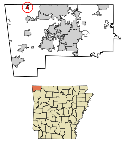
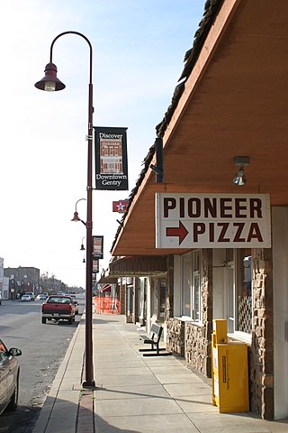
Gravette is a city in Benton County, Arkansas, United States. The population was 3,547 as of the 2020 census. It is part of the Northwest Arkansas region.

<span class="mw-page-title-main">Lowell, Arkansas</span> City in Arkansas, United States

Lowell is a city in Benton County, Arkansas, United States. Located within the Ozarks, the first settlement was along Old Wire Road in the 1840s, and although destroyed during the Civil War, the community was reestablished by J. R. McClure and thrived when the St. Louis–San Francisco Railway came through the area in the 1880s. The city is a growing bedroom community within the rapidly growing Northwest Arkansas region. Lowell is the headquarters of trucking company J.B. Hunt. Lowell's population was 9,839 at the 2020 census, an increase of 34% since 2010.

<span class="mw-page-title-main">Siloam Springs, Arkansas</span> City in Arkansas, United States

Siloam Springs is a city in Benton County, Arkansas, United States, and located on the western edge of the Northwest Arkansas metropolitan area. As of the 2020 census, the population of the city was 17,287. The community was founded in 1882 and was characterized by the purported healing powers of the spring water feeding Sager Creek and trading with nearby Native American tribes. The city shares a border on the Arkansas–Oklahoma state line with the city of West Siloam Springs, Oklahoma, which is within the Cherokee Nation territory. It is home of John Brown University.

<span class="mw-page-title-main">Springdale, Arkansas</span> City in Arkansas, United States

Springdale is the fourth-most populous city in Arkansas, United States. It is located in both Washington and Benton counties in Northwest Arkansas. Located on the Springfield Plateau deep in the Ozark Mountains, Springdale has long been an important industrial city for the region. In addition to several trucking companies, the city is home to the world headquarters of Tyson Foods, the world's largest meat producing company. Originally named Shiloh, the city changed its name to Springdale when applying for a post office in 1872. It is included in the four-county Northwest Arkansas Metropolitan Statistical Area, which is ranked 102nd in terms of population in the United States with 546,725 in 2020 according to the United States Census Bureau. The city had a population of 84,161 at the 2020 Census.

<span class="mw-page-title-main">Altus, Arkansas</span> City in Arkansas, United States

Altus is a city in Franklin County, Arkansas, United States. Located within the Arkansas River Valley at the edge of the Ozark Mountains, the city is within the Fort Smith metropolitan area. The epicenter of the Altus American Viticultural Area (AVA) within Arkansas Wine Country, the city is home to four wineries. Although founded as a coal mining community, the wine industry has driven the Altus economy since the first vineyards were planted in 1872. The population was 758 at the 2010 census, down from 817 at the 2000 census. In 2020, the population was 669 and was estimated as unchanged in 2021 and 2022.

<span class="mw-page-title-main">Sulphur Springs, Texas</span> City in Texas, United States

Sulphur Springs is a city in and the county seat of Hopkins County, Texas, United States. As of the 2020 census, its population was 15,941. Sulphur Springs is located along the western edge of Northeast Texas.

<span class="mw-page-title-main">Arkansas Highway 59</span> State highway in Arkansas, United States

Arkansas Highway 59 is a north–south state highway in Northwest Arkansas. The route runs 93.24 miles (150.06 km) from Arkansas Highway 22 in Barling north to the Missouri state line through Van Buren, the county seat of Crawford County. Highway 59 parallels US 59 between Siloam Springs and Fort Smith. Since US 59 goes through Arkansas, AR 59 is the only Arkansas state highway to share its numbering with a federal highway that goes through Arkansas.

<span class="mw-page-title-main">Old Spanish Treasure Cave</span> Cave in United States of America

The Old Spanish Treasure Cave is located on Hwy 59 between Sulphur Springs and Gravette, Arkansas in the northwest corner of the state. It has been a popular tourist attraction since at least 1908. It is still open to the public, with guided tours and other activities such as panning for treasure and finding fossils.

Township 11 is one of thirteen current townships in Benton County, Arkansas, USA. As of the 2010 census, its total population was 12,273.

Gravette High School is a comprehensive public high school located in the fringe town of Gravette, Arkansas, United States. The school provides secondary education for students in grades 8 through 12. It is one of nine public high schools in Benton County, Arkansas and the sole high school administered by the Gravette School District.

Gravette School District is a public school district based in Gravette, Arkansas, United States. The Gravette School District provides early childhood, elementary and secondary education for more than 1,800 pre-kindergarten through grade 12 students at its four facilities.

References

  1. "2020 U.S. Gazetteer Files". United States Census Bureau. Retrieved October 29, 2021.
  2. 1 2 U.S. Geological Survey Geographic Names Information System: Sulphur Springs, Benton County, Arkansas
  3. 1 2 "Geographic Identifiers: 2010 Demographic Profile Data (G001): Sulphur Springs city, Arkansas". U.S. Census Bureau, American Factfinder. Archived from the original on February 12, 2020. Retrieved September 24, 2013.
  4. History of Benton, Washington, Carroll, Madison, Crawford, Franklin, and Sebastian Counties, Arkansas. Higginson Book Company. 1889. p. 118.
  5. Arkansas Atlas & Gazetteer, DeLorme, 2004, 2nd edition, p. 22, ISBN   0-89933-345-1
  6. Black, J. Dickson (1975). History of Benton County. Little Rock, Arkansas: International Graphics Industries. Retrieved April 1, 2024.
  7. "Healing Waters: Online Exhibit". Shiloh Museum of Ozark History. Archived from the original on April 1, 2024. Retrieved April 1, 2024.
  8. "Land Developments". Manufacturers Record. 79 (16): 111. April 21, 1921. Retrieved April 22, 2024.
  9. "Association of Arkansas Grape Growers". Agricultural Cooperation. VII (23): 451. November 16, 1929. Retrieved April 22, 2024.
  10. 1 2 "Co-operative Colony Found on Ozark Hills". The Christian Science Monitor. June 17, 1930. p. 1. Retrieved April 22, 2024.
  11. "Ozark League Commission to Meet at Eureka Springs". St. Louis Post-Dispatch. November 16, 1934. p. 12E. Retrieved April 22, 2024.
  12. Pearson, T. Gilbert (November–December 1923). "Bird Sunday". The Audubon Societies. 25: 426. Retrieved April 22, 2024.
  13. "Legit Items". Variety: 15. August 30, 1923. Retrieved April 22, 2024.
  14. "Photograph: Ozark Colony Lodge". Wisconsin Historical Society. Wisconsin Historical Society. Archived from the original on April 22, 2024. Retrieved April 22, 2024.
  15. "Miscellaneous Construction". Manufacturers Record: 42. April 7, 1932. Retrieved April 22, 2024.
  16. "Miscellaneous Construction". Manufacturers Record: 31. April 14, 1932. Retrieved April 22, 2024.
  17. Glass, Renee (August 20, 2017). "Here's what happened this week in history in the Ozarks: Aug. 21–26". Springfield News-Leader. Archived from the original on March 31, 2023. Retrieved April 22, 2024.
  18. "Photograph: Totem Pole". Wisconsin Historical Society. Wisconsin Historical Society. Archived from the original on April 22, 2024.
  19. Rinehart, Mikey, Jr. (December 1926). "Marking History on Wood". Hunter-Trader-Trapper. LIII (6): 14. Retrieved April 22, 2024.{{cite journal}}: CS1 maint: multiple names: authors list (link)
  20. Hudson, Ralph M. "Art in Arkansas". The Arkansas Historical Quarterly. 3 (4 (Winter 1944)): 299–350. doi:10.2307/40037844 . Retrieved April 22, 2024.
  21. Bennett, Swannee (2021). Arkansas Made: A Survey of the Decorative, Mechanical, and Fine Arts Produced in Arkansas Through 1950: Volume 2 (2 ed.). USA: The University of Arkansas Press. p. 261. ISBN   978-1-68226-144-6 . Retrieved April 22, 2024.
  22. "Census of Population and Housing". Census.gov. Retrieved June 4, 2015.
  23. "2020 Census Profile, Sulphur Springs, Arkansas". United States Census Bureau. Retrieved March 29, 2024.
  24. "2020 CENSUS - SCHOOL DISTRICT REFERENCE MAP: Benton County, AR" (PDF). U.S. Census Bureau . Retrieved May 25, 2022.