
The climate of the Alps is the climate, or average weather conditions over a long period of time, of the exact middle Alpine region of Europe. As air rises from sea level to the upper regions of the atmosphere the temperature decreases. The effect of mountain topography on prevailing winds is to force warm air from the lower region into an upper zone where it expands in volume at the cost of a proportionate loss of heat, often accompanied by the precipitation of moisture in the form of snow, rain or hail.

Mount Cameroon is an active volcano in the South West region of Cameroon next to the city of Buea near the Gulf of Guinea. Mount Cameroon is also known as Cameroon Mountain or Fako or by its indigenous name Mongo ma Ndemi. Mount Cameroon is ranked 22nd by topographic isolation.

The Ethiopian Highlands is a rugged mass of mountains in Ethiopia in Northeast Africa. It forms the largest continuous area of its elevation in the continent, with little of its surface falling below 1,500 m (4,900 ft), while the summits reach heights of up to 4,550 m (14,930 ft). It is sometimes called the "Roof of Northeastern Africa" due to its height and large area. It is the only country in the region with such a high elevated surface. This elevated surface is bisected diagonally by the Great East African Rift System which extends from Syria to Mozambique across the East African Lakes. Most of the Ethiopian Highlands are part of central and northern Ethiopia, and its northernmost portion reaches into Eritrea.

The Western Guinean lowland forests ecoregion is a tropical moist broadleaf forest ecoregion of West Africa. It is centered on Liberia, with portions in surrounding countries. It is the westernmost tropical rainforest in Africa, and has high levels of species endemism, with over 200 species of endemic plants.

The Central Range montane rain forests is a tropical moist forest ecoregion on the island of New Guinea. The ecoregion covers the Central Range of the New Guinea Highlands, which extends along the spine of the island. The montane rain forests of the ecoregion are distinct from the surrounding lowland forests, and are home to many endemic plants and animals.
The Southern Anatolian montane conifer and deciduous forests ecoregion, in the Mediterranean forests, woodlands, and scrub biome, is in the eastern Mediterranean Basin.

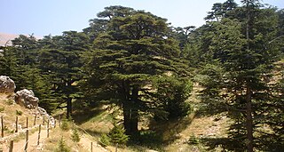
The Nimba Range forms part of the southern extent of the Guinea Highlands. The highest peak is Mount Richard-Molard on the border of Côte d'Ivoire and Guinea, at 1,752 m (5,748 ft). "Mount Nimba" may refer either to Mount Richard-Molard or to the entire range. Other peaks include Grand Rochers at 1,694 m (5,558 ft), Mont Sempéré at 1,682 m (5,518 ft), Mont Piérré Richaud at 1,670 m (5,480 ft), Mont Tô at 1,675 m (5,495 ft), and Mont LeClerc 1,577 m (5,174 ft), all of them are located in Guinea. Mount Nimba Strict Nature Reserve of Guinea and Côte d'Ivoire covers significant portions of the Nimba Range.

The Peninsular Malaysian montane rain forests is an ecoregion on the Malay Peninsula. It occupies the mountainous spine of the peninsula in Malaysia and southernmost Thailand. It is in the tropical and subtropical moist broadleaf forests biome.

The Sulawesi montane rain forests is a tropical moist forest ecoregion in Indonesia. It includes the highlands of Sulawesi.

The Vogelkop montane rain forests is a tropical moist forest ecoregion in western New Guinea. The ecoregion covers the mountains of western New Guinea's Bird's Head and Bomberai peninsulas.

The Southeastern Papuan rain forests is a tropical moist forest ecoregion in southeastern New Guinea. The ecoregion covers the mountainous center and coastal lowlands of the Papuan Peninsula.

The Northern Annamites rain forests ecoregion covers the rugged and relatively unexplored northern Annamite Mountains of central Laos and Vietnam. There are high numbers of endemic plant species, and the relative remoteness and isolation of the area supports many rare and endangered animals. Rainfall is somewhat less than the lowland rainforest of the lower elevations in Vietnam, and the temperatures slightly cooler due to the higher elevation.
The Southern Annamites montane rain forests ecoregion covers a region of high biodiversity in the central and southern mountains of the Annamite Range in Vietnam. Terrain ranges from wet lowland forest to evergreen hardwood and conifer montane rain forest. There is a short dry season centered on January–February, but fog and dew are common throughout the year and support a lush forest character.

The Sierra Madre de Chiapas moist forests is a tropical moist broadleaf forest ecoregion in southern Mexico and southern Guatemala, extending into the northwestern corner of El Salvador.
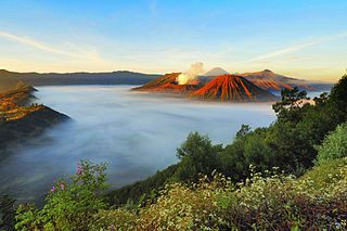
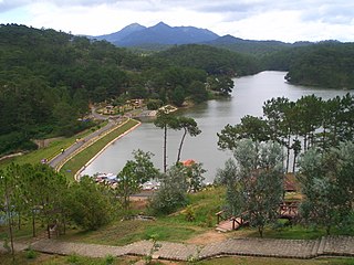
The Eastern Java–Bali montane rain forests ecoregion covers the higher altitude mountain rainforests on the eastern side of the island of Java, and most of the center of the island of Bali in Indonesia. The region has a number of active volcanoes, but is under pressure from growing human populations pushing into higher elevations and more marginal land. With elevations rising from sea level to 3,426 metres (11,240 ft), and precipitation varying between rainforest and drier forest levels, the area has many different forest types – evergreen, deciduous and semi-alpine.

The Sumatran lowland rain forests ecoregion covers the lowland forests running the length of the island of Sumatra in Indonesia. The region is one of exceptionally high biodiversity, similar to Borneo and New Guinea islands. Many endangered mammals species are present, and over 450 species of birds have been found in the region. In recent years, illegal logging and human encroachment have put great strain on this ecoregion.

The Mindanao montane rain forests ecoregion covers the montane forests - the zone between the lowland forest and the treeline - in the mountains on the island of Mindanao in the Philippines. Because the ecoregion covers only elevations above 1,000 metres (3,300 ft), it exists in seven discontinuous patches surrounded by lowland rainforest. Biodiversity is high, both because of the isolation of separate mountain ranges that have led to species variation within the island, and because of the altitude zonation. Because most of the surrounding lowland forest has been cleared for human use, the montane regions have become an important refuge for rare and endemic species.

The Greater Negros–Panay rain forests ecoregion covers the central Visayan Islands in the Philippines, including the islands of Panay, Negros, Cebu, Masbate, Sibuyan, Ticao, Guimaras, Romblon, Tablas, Siquijor, and Bohol, but excludes Leyte and Samar. During the last ice age, these were all on the same island. The lack of a land bridge to Asia during the ice age kept most Asian megafauna, including elephants and tigers, from reaching the Philippines and the Visayan Islands, which hosts many unique and endemic species with some exclusive only to an island.

The Mindanao–Eastern Visayas rain forests ecoregion covers the lowland rain forests of the island of Mindanao and of the easternmost of the Visayas Islands in the Philippines. Although 63% of this ecoregion is covered with closed broadleaf evergreen forest or open forest, much of this has been disturbed in the past by human activity, and many of the rare species of the area have been relegated to the isolated areas or higher elevations.

The Western Java rain forests ecoregion covers the lowland rain forests below 1,000 meters in elevation in the western half of the island of Java in Indonesia. There are a variety of forest types - evergreen, semi-evergreen, moist deciduous, and even some patches of freshwater swamp. The forests have degraded by conversion of the low areas to agriculture, and by logging. National parks protect some of the last remaining untouched rain forest. A number of endangered mammals are found in the ecoregion, including the Javan rhinoceros, the silvery gibbon, and the Javan surili.

