Related Research Articles

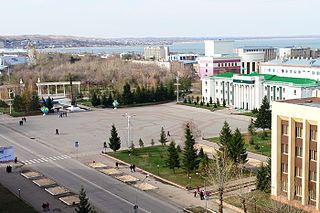
Almaty, formerly known as Alma-Ata and Verny, is the largest city in Kazakhstan, with a population of about 2,000,000 people, about 11% of the country's total population, and more than 2.7 million in its built-up area that encompasses Talgar, Boraldai, Otegen Batyr and many other suburbs. It served as capital of the Kazakh Soviet Socialist Republic and later independent Kazakhstan from 1929 to 1997. In 1997, the government relocated the capital to Akmola in the north of the country.

Petropavl or Petropavlovsk, is a city on the Ishim River in northern Kazakhstan close to the border with Russia, about 261 km west of Omsk along the Trans-Siberian Railway. It is the capital of the North Kazakhstan Region. Population: 218,956. The city is also known colloquially in the Kazakh language as Kyzylzhar.
Kokshetau, formerly known as Kokchetav (1827–1993), is a city in northern Kazakhstan and the capital of Akmola Region, lying in the north of Kokshetau Uplands, on the southern shore of Lake Kopa and the southern edge of the Ishim Steppe. Earlier, it was the centre of Kokshetau Region, which was abolished in 1997. It is also situated at the junction of the Trans-Kazakhstan and South Siberian railways. Kokshetau lies at an elevation of approximately 234 m (768 ft) above sea level.
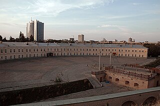
The Kyiv Fortress or Kiev Fortress is a historical and architectural monument complex of Russian fortifications in Kyiv, Ukraine built from the 17th through 19th centuries. Construction began after the 1654 Council in Pereyaslav, on the site of the already existing fortified monastery of Kyiv Pechersk Lavra. Located on the hills of the high right bank of the Dnieper, bounded on the north by the Klovsky ravine, on the south and west - by the slopes of the Lybid River valley.
Talgar is a town in Almaty Region, southeastern Kazakhstan. It is the administrative center of Talgar District. The town is located between Almaty and Esik, 25 km from Almaty and several kilometres east of Birlik. Population: 45,529 ; 43,353 .

Qazançı, also known as Shahkert, is a village and municipality in the Julfa District of Nakhchivan, Azerbaijan.
Boyəhməd is a village and municipality in the Julfa District of Nakhchivan, Azerbaijan. It is located 64 km in the north from the district center, on the left bank of the Alinjachay River, on the slope of the Zangezur ridge. There are secondary school, club, library and a medical center in the village. It has a population of 267.
Vayxır is a village and municipality in the Babek District of Nakhchivan, Azerbaijan. It is located 21 km in the north from the district center, on the left bank of the Nakhchivanchay River. Its population is busy with grain-growing, poultry and animal husbandry. There are secondary school, culture house and a medical center in the village. It has a population of 1,309.
Oğlanqala is a village and municipality in the Sharur District of Nakhchivan, Azerbaijan. It is located on the bank of the Arpachay, opposite from the village of Dizə, Sharur (Dize). Its population is busy with grain-growing and animal husbandry. There are secondary school, cultural house, library, a medical center, the fortress walls from architectural monuments and 3 towers in the village. It has a population of 2,959.
Jankent is a deserted town east of the Aral Sea in modern Kazakhstan. It is known from Arab writings of the 10th century AD as the capital of the steppe empire of the Oghuz Turks. Archaeological research has provided information about the appearance of the town and confirmed the date, but also points to earlier origins.

The Semirechyenskaya Oblast was an oblast (province) of the Russian Empire. It corresponded approximately to most of present-day southeastern Kazakhstan and northeastern Kyrgyzstan. It was created out of the territories of the northern part of Khanate of Kokand that had been part of Kazakh Khanate. Its site of government was Verniy.
Jerina's town, Brangović is an archaeological site of an early medieval fortress, located in the village of Brangović, western Serbia. The fort is located on the east bank of the Gradac.

The art of Kazakhstan covers all forms of art created throughout history by the peoples living on the territory of modern-day Kazakhstan. Throughout most periods, much of the population of Kazakhstan was nomadic, or at least moved regularly across the vast country. The great majority of the art of Kazakhstan is applied art: the decoration of practical objects, including household utensils and patterned harnesses, through art forms such as carpet-weaving, pottery, and leatherwork. The art of Kazakhstan also includes architecture, fine arts, and sculpture.
The Akkainar and Zhartas petroglyphs are located in the Akkainar River valley in Zhambyl district, Almaty Region, Kazakhstan.
The Katutau mountains are located in Altyn-Emel National Park, Kazakhstan. They are volcanic in origin. The highest point of Katutau reaches a height of 1720 m.
The Wooden Lake is a reservoir in the Almaty Region of Kazakhstan. The reservoir was formed presumably at the end of the nineteenth century, or at the beginning of the last century. The westernmost branch of the Sharyn river is supported by sand moving from the river, so the trees end up in the water. Hence the name of the lake – "Wooden".
Sagabuyen ancient settlement is one of the medieval cities of the so - called Northern section of the Silk Road, which ran along the spurs of the Zhetysu Alatau from the crossing to Or to Lake Alakol and the Dzungarian Gate.
Karamergen is a medieval Kazakh settlement.
Aktam ancient settlement dates back to the X–XII centuries and was located in Almaty region, Balkhash district, on the Bank of the dry arm of Ortabakanas, on the territory of the saryesik-Atyrau desert, 120 km North of the village of Bakanas.