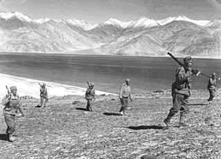
The Sino–Indian War, also known as the China–India War or the Indo–China War, was an armed conflict between China and India that took place from October to November 1962. It was a military escalation of the Sino–Indian border dispute. Fighting occurred along India's border with China, in India's North-East Frontier Agency east of Bhutan, and in Aksai Chin west of Nepal.

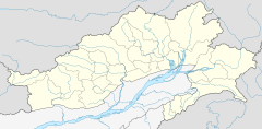
Arunachal Pradesh is a state in northeast India. It was formed from the North-East Frontier Agency (NEFA) region, and India declared it as a state on 20 February 1987. Itanagar is its capital and largest town. It borders the Indian states of Assam and Nagaland to the south. It shares international borders with Bhutan in the west, Myanmar in the east, and a disputed 1,129 km border with China's Tibet Autonomous Region in the north at the McMahon Line. Arunachal Pradesh is claimed in its entirety by China as South Tibet as part of the Tibet Autonomous Region; China occupied some regions of Arunachal Pradesh in 1962 but later withdrew its forces.

The McMahon Line is the boundary between Tibet and British India as agreed in the maps and notes exchanged by the respective plenipotentiaries on 24–25 March 1914 at Delhi, as part of the 1914 Simla Convention. The line delimited the respective spheres of influence of the two countries in the eastern Himalayan region along northeast India and northern Burma (Myanmar), which were earlier undefined. The Republic of China was not a party to the McMahon Line agreement, but the line was part of the overall boundary of Tibet defined in the Simla Convention, initialled by all three parties and later repudiated by the government of China. The Indian part of the Line currently serves as the de facto boundary between China and India, although its legal status is disputed by the People's Republic of China. The Burmese part of the Line was renegotiated by the People's Republic of China and Myanmar.

Tawang district is the smallest of the 26 administrative districts of Arunachal Pradesh state in northeastern India. With a population of 49,977, it is the eighth least populous district in the country.

Tawang is a town and administrative headquarter of Tawang district in the Indian state of Arunachal Pradesh. It lies on NH-13 section of Trans-Arunachal Highway. The town was once the headquarter of the Tawang Tract, which is now divided into the Tawang district and the West Kameng district. Tawang continues as the headquarters of the former. Tawang is the number one tourist destination of Arunachal Pradesh.
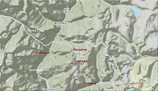
In 1986–87, a military standoff took place between India and China in the Sumdorong Chu Valley bordering the Tawang district, Arunachal Pradesh and Cona County, Tibet. It was initiated by China moving a company of troops to Wangdung, a pasture to the south of Sumdorong Chu that India believed to be its territory. The Indian troops stood their ground on the neighbouring Longro La ridge and both the sides moved a large number of troops to the border. The crisis was diffused after the visit of Indian External Affairs minister to Beijing in May 1987. The standoff gave rise to fears of escalation. Subsequently, India and China formulated agreements for managing future border tensions.

The Sino–Indian border dispute is an ongoing territorial dispute over the sovereignty of two relatively large, and several smaller, separated pieces of territory between China and India. The territorial disputes between the two countries result from the historical consequences of colonialism in Asia and the lack of clear historical boundary demarcations.

Tsona City, formerly Tsona County, is a county-level city in Shannan Prefecture in the southeastern part of the Tibet region of China. Tsona means "The face of the [Nara Yumco] lake" in Tibetan. It lies immediately to the north of the McMahon Line agreed as the mutual border between British India and Tibet in 1914. China has not accepted the 1914 border delineation, but treats it as the Line of Actual Control (LAC). Tsona also borders Bhutan on its southwest.

Mechukha or Menchukha is a town, assembly constituency and subdivision, situated 6,000 feet (1,829 m) above sea level in the Mechukha Valley of Yargep Chu/ Siyom River in Shi Yomi district of Arunachal Pradesh state of India. Before the 1950s, Mechuka valley was known as Pachakshiri.

The Subansiri is a trans-Himalayan river and a tributary of the Brahmaputra River that flows through Tibet's Lhuntse County in the Shannan Prefecture in Southwestern China, and the Indian states of Arunachal Pradesh and Assam. The Subansiri is approximately 518 kilometres (322 mi) long, with a drainage basin 32,640 square kilometres (12,600 sq mi). It is the largest tributary of the Brahmaputra contributing 7.92% of the Brahmaputra's total flow.
The Bum La Pass is a border pass between China's Tsona County in Tibet and India's Tawang district in Arunachal Pradesh. It is 37 km away from the town of Tawang in India's Tawang district and 43 km from the town of Tsona Dzong in China's Tsona County. The pass currently serves as a trading point between Arunachal Pradesh and Tibet. It is also an agreed Border Personnel Meeting point for the security forces of China and India.
Milakatong La or Menlakathong La is a historic mountain pass along the trade route between Tawang in India's Arunachal Pradesh and Tsona Dzong in Tibet's Shannan province via the valley of Tsona Chu.
Namka Chu or Kejielang River is a tributary of Nyamjang Chu that flows along the disputed border between India and China. The Indian side of the border is the Tawang district in Arunachal Pradesh. The Tibetan side of the border is in Tsona Dzong, Shannan province of Tibet. Namka Chu originates near the trijunction of Tibet, Bhutan and India and flows east for 26 km before joining Nyamjang Chu. It is about 200 kilometers away from the Misamari railhead and 60 kilometers from the Tawang road head. The Namka Chu valley was the scene of some of the most fierce fighting during the 1962 Sino-Indian war.
Dhola Post was a border post set up by the Indian Army in June 1962, at a location called Che Dong, in the Namka Chu river valley area disputed by China and India. The area is now generally accepted to be north of the McMahon Line as drawn on the treaty map of 1914, but it was to the south of the Thagla Ridge, where India held the McMahon Line to lie. On 20 September 1962, amidst various border tensions, the post was attacked by Chinese forces from the Thagla Ridge, and sporadic fighting continued till 20 October when an all-out attack was launched by China leading to the Sino-Indian War. Facing an overwhelming force, the Indian Army evacuated the Dhola Post as well as the entire area of Tawang, retreating to Sela and Bomdila. After the war, the post was left unoccupied until the 1986 Sumdorong Chu standoff, after which the area was again strengthened by the Indian Army.
The Nyamjang Chu, or Nyashang Chu (Tibetan: ཉ་བཤང་ཆུ, Wylie: nya bshang chu, THL: nya shang chu) is a cross-border perennial river that originates in the Shannan Prefecture of Tibet and flows into the Arunachal Pradesh state of India, joining the Tawang Chu river just before it enters Bhutan. The Nyamjang Chu valley has provided the traditional communication route between Tawang and Tibet. The valley near the town of Zemithang in the Tawang district, called the Pangchen Valley, is known for its serene beauty and forms one of the wintering locations for the black-necked crane.

Tawang Chu is the main river of the Tawang district in Arunachal Pradesh, India. The entire district may be regarded as the basin of the Tawang Chu river. In addition, two south-flowing rivers from Tibet, viz., the Tsona Chu and Nyamjang Chu, join the river within the district. The combined river flows west into Bhutan, where it progresses to the Manas River and flows into the Assam state of India.
Longju or Longzu is a disputed area in the eastern sector of the China–India border, controlled by China but claimed by India. The village of Longju is located in the Tsari Chu valley 2.5 kilometres (1.6 mi) south of the town of Migyitun, considered the historical border of Tibet. The area of Longju southwards is populated by the Tagin tribe of Arunachal Pradesh.
Chumi Gyatse Falls, called Domtsang and Dongzhang waterfalls in Tibetan and Chinese languages respectively, are a collection of waterfalls in the Tawang district in Arunachal Pradesh, India, close to the border with the Tibet region of China. According to the local Buddhist tradition, the 108 holly water falls which originate from in-between the mountains symbolise the blessings of Guru Padmasambhava. The Chumi Gyatse Falls are close to the Line of Actual Control, the de facto border between China and India, just 250 metres away according to one account.

The Yangtse clash of 9 December 2022 occurred at night between the troops of the Indian Army and the Chinese People's Liberation Army (PLA) along their mutually contested Line of Actual Control (LAC) in the Yangtse region of Tawang in the Indian state of Arunachal Pradesh. Violent clashes ensued after the two armies confronted each other with nail-studded clubs and other melee weapons near positions on a border ridgeline in close vicinity of the revered Buddhist site of Chumi Gyatse Falls. The border incident marked the most serious clash between the two armies along their undemarcated frontier since the Galwan Valley clash in June 2020, which had led to the deaths of 20 Indian soldiers and an unknown number of dead on the Chinese side.
Tulung La (Tibetan: ཐུ་ལུང་ལ་, Wylie: thu lung la) is a border pass between the Tsona County in the Tibet region of China and India's Tawang district in Arunachal Pradesh. It is in the eastern part of the two districts, close to the Gori Chen cluster of mountains, on a watershed between the Tsona Chu river in Tibet and the Tawang Chu in the Tawang district. The watershed ridge forms the border between Tibet and India as per the McMahon Line. Tulung La provided an invasion route to China during the 1962 Sino-Indian War. It is also the scene of occasional clashes between the two sides.