
Congress Street Grounds is a former baseball ground located in Boston, Massachusetts. The ballpark, as the name implies, was along Congress Street, near the intersection of Thompson Place, and not far from the Fort Point Channel on South Boston Flats, a newly filled in piece of land on Boston Harbor. The ground was home to the Boston Reds, that played in the Players' League in 1890 and the American Association in 1891.

Completed in 1796, the Pawtucket Canal was originally built as a transportation canal to circumvent the Pawtucket Falls of the Merrimack River in East Chelmsford, Massachusetts. In the early 1820s it became a major component of the Lowell power canal system. with the founding of the textile industry at what became Lowell.
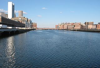
Fort Point Channel is a maritime channel separating South Boston from downtown Boston, Massachusetts, feeding into Boston Harbor. The south part of it has been gradually filled in for use by the South Bay rail yard and several highways. At its south end, the channel once widened into South Bay, from which the Roxbury Canal continued southwest where the Massachusetts Avenue Connector is now. The Boston Tea Party occurred at its northern end. The channel is surrounded by the Fort Point neighborhood, which is also named after the same colonial-era fort.

The Charles River Esplanade of Boston, Massachusetts, is a state-owned park situated in the Back Bay area of the city, on the south bank of the Charles River Basin.

The Cochituate Aqueduct was an aqueduct in Massachusetts that brought water to Boston from 1848 to 1951.

Fort Point is a neighborhood or district of Boston, Massachusetts, and where a fort stood which guarded the city in colonial times.

The Moseley Wrought Iron Arch Bridge, also known as the Upper Pacific Mills Bridge, is a historic, riveted, wrought iron bowstring arch bridge now located on the campus of Merrimack College in North Andover, Massachusetts. It was added to the National Historic Civil Engineering Landmark list in 1998 and was originally part of the North Canal Historic District on the National Register of Historic Place. It is the oldest iron bridge in Massachusetts, and one of the oldest iron bridges in the United States. It was the first bridge in the United States to use riveted wrought iron plates for the triangular-shaped top chord.

The French King Bridge is the three-span "cantilever arch" bridge that crosses the Connecticut River on the border between the towns of Erving and Gill, Massachusetts, United States. The bridge, part of Massachusetts Route 2, carries automobile, bicycle, and pedestrian traffic and is owned and managed by the Massachusetts Department of Transportation (MassDOT).

The Hampden County Memorial Bridge is a reinforced-concrete arch bridge that spans the Connecticut River between Springfield, Massachusetts and West Springfield, Massachusetts, constructed in 1922. The bridge is owned by Massachusetts Highway Department and is located on Massachusetts Route 147. It spans 209 feet (64 m) and rises 29.71 feet (9.06 m) above the river.

The Charles River Bridge is a pair of railroad single-leaf, through-truss, rolling bascule bridges across the Charles River that connects North Station in Boston, Massachusetts to MBTA Commuter Rail lines in northern Massachusetts, United States.
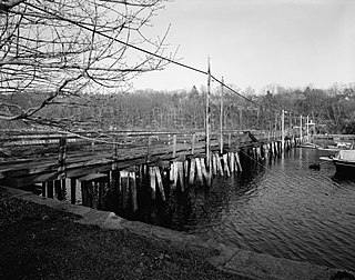
The Annisquam Bridge is a historic bridge in Annisquam, Massachusetts, a village within the city of Gloucester. The bridge was built in 1861 to replace an earlier 1847 bridge that crossed Lobster Cove. It is a wooden pile bridge, a type of which only two others were found in New England as part of a c. 1979 survey. The bridge is 440 feet (130 m) long and 30 feet (9.1 m) wide, and had a drawbridge section in the center that was moved by a hand-cranked winch. The bridge has repeatedly been the subject of safety closings and restorative work over the course of the 20th century, and was completely rebuilt in 1946–7, removing the draw. Despite this, it was closed to vehicular traffic in 1968, and pedestrian traffic in 1987. The bridge has since been rehabilitated, and is open to pedestrian traffic.

Summer Street in Boston, Massachusetts, extends from Downtown Crossing in the Financial District, over Fort Point Channel, and into the Seaport District to the southeast. In the mid-19th century it was also called Seven Star Lane.
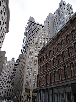
Franklin Street is located in the Financial District of Boston, Massachusetts, United States. It was developed at the end of the 18th century by Charles Bulfinch, and included the now-demolished Tontine Crescent and Franklin Place.

Congress Street in Boston, Massachusetts, is located in the Financial District and South Boston. It was first named in 1800. It was extended in 1854 as far as Atlantic Avenue, and in 1874 across Fort Point Channel into South Boston. Today's Congress Street consists of several segments of streets, previously named Atkinson's Street, Dalton Street, Gray's Alley, Leverett's Lane, Quaker Lane, and Shrimpton's Lane.

The Massachusetts Archives is the state archive of Massachusetts. It "serves the Commonwealth and its citizens by preserving and making accessible the records documenting government action and by assisting government agencies in managing their permanent records." The archives occupies quarters on the Columbia Point peninsula in Boston's Dorchester neighborhood on the University of Massachusetts Boston campus. For fiscal year 2010 the state budgeted $389,815 to the archives. The Massachusetts Secretary of the Commonwealth bears responsibility for its administration.
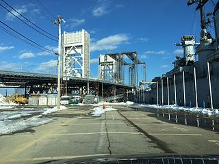
The Fore River Bridge spans the Weymouth Fore River between Quincy and Weymouth, Massachusetts. The total length of the bridge including the approaches is 2,216 feet (675 m).
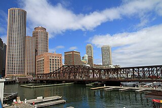
The Northern Avenue Bridge, also known as the Old Northern Avenue Bridge, is a bridge that spans Fort Point Channel Boston, Massachusetts. Built in 1908, it was closed to vehicle traffic in 1997 and operated as a pedestrian bridge until December 2014 when it was closed after inspectors found that thirteen floor beams were unsafe for pedestrians. In an October 26, 2015 letter, the Coast Guard informed the City of Boston that the bridge was a 'hazard to navigation' due to the risk of it falling into the Fort Point Channel and requested removal of its most vulnerable portion. The center span of the truss also carried a single track for the Union Freight Railroad, although it was designed for two tracks. From 1912 to 1948, the bridge abutted a floating firehouse for Engine 44 of the Boston Fire Department. Following its closure as a road bridge, various redevelopment schemes have been proposed for the bridge, as well as outright demolition of the span.
A retractile drawbridge is a rare type of moveable bridge in which the span is pulled away diagonally on rails. It is a variant of the retractable bridge. Only four examples are known to exist in the United States. It is believed to have been invented by T. Willis Pratt in the 1860s.

The Boston Public Garden Foot Bridge is a pedestrian bridge crossing the lagoon in Boston Public Garden, in Boston, Massachusetts, United States. Built in 1867, it was the world's shortest functioning suspension bridge before its conversion to a girder bridge in 1921.


