Summit cross

Last updated
Otto Barth (1876-1916), Morning prayers by the Kalser alpine guides on the Grossglockner, oil on canvas, 1911 Morgengebet der Kalser Bergfuhrer auf dem Grossglockner.jpg
Otto Barth (1876–1916), Morning prayers by the Kalser alpine guides on the Großglockner, oil on canvas, 1911

A summit cross (German : Gipfelkreuz) is a Christian cross on the summit of a mountain or hill that marks the top. Often there will be a summit register (Gipfelbuch) at the cross, either in a container or other weatherproof case.

Contents

Various other forms of marking or symbol such as cairns, prayer flags or ovoos may be found around the world on passes and hills, in particular on sacred mountains. In the Italian Alps, a Madonna is sometimes placed at the summit instead of a cross.

Description

Summit crosses are normally about two to four metres high and are usually made of wood or metal. In April 2010, the world's first glass summit cross was erected on the Schartwand (2,339 m) in Salzburg's Tennengebirge mountains. [1] Summit crosses are mainly found in Catholic regions of the Alps, especially in Austria, Switzerland and Bavaria, mountainous regions of Poland, but also in America, in areas with both Protestant and Catholic populations. In Slovenia, summit crosses were traditionally placed on mountaintops as symbols of faith, but their numbers were limited during the communist regime in Yugoslavia. They usually stand on mountains whose summits are above the tree line, but they are also found in the German Central Uplands, for example in the Black Forest on the Herzogenhorn.

History

By the end of the 13th century a few large crosses had been erected in passes and on hills. Examples from this period include the Confin Cross in St. Valentin on the Mals Heath, which also acted as a boundary marker, or crosses on the Arlberg, the Gardena Pass or Birnlücke. [2] An early example of a large cross, visible from the valley floor, being set up on a mountain top, occurred during the first successful climb of Mont Aiguille in 1492, when three crosses were put up at the corner of the summit plateau. [3] In the 16th century crosses were erected with increasing frequency on mountain peaks, especially for the purpose of marking alpine pasture and municipal boundaries. In the 17th century, especially during the Thirty Years' War, these religious symbols gained importance. The crosses of this period were mostly simple wooden ones hewn from branches found near the site, or house crucifixes. During this time crosses were often made with two cross beams in the form of so-called patriarchal crosses (or Scheyern crosses). These "weather crosses" were intended to supersede the old pagan superstitions associated with thunder, storm and hail. Further layers of Christian imagery as perceived by the Romantic generation made summit crosses a motif favoured by the painter Caspar David Friedrich in more than one of his mystic landscapes. [4]

During the 19th century the summits of many mountains were adorned with what were usually simple, wooden crosses during the course of mountaineering expeditions or survey work, both of which were on the increase. Large summit crosses in the modern sense — that is pieces designed specifically for mountain tops by expert craftsmen — were not really introduced until the end of the 19th century. One known exception is that of the Kleinglockner and Grossglockner, which were given large summit crosses in 1799 and 1800 as part of their first ascent. [2] These crosses, in addition to their religious function, were also used, for example, as lightning conductors, and fitted with meteorological instruments such as barometers. [5] During the 19th century there were several attempts to erect secular symbols such as pyramids, obelisks or flags instead of crosses, usually dedicated to secular rulers. One example was the construction of the so-called Emperor Obelisk on the Ortler in 1888. [6] The 20th century introduced modern materials and technology: a summit cross erected in 1977 on Carrauntoohil, the highest summit in Ireland, originally featured a windmill that powered light bulbs on the cross. [7]

What summit crosses may express can be exemplified by the crosses erected and re-erected on the comparatively insignificant Butte de Warlencourt, a pre-Christian tumulus on the Somme, only some 20m above the surrounding terrain but a scene of intense fighting during World War I, when it was the objective of costly and fruitless British attacks during the battle of the Somme: "this pagan memorial was Christianized by bombardment and large numbers of dead," and claimed with first a British cross (1917), then a German one (1918), the latter being removed during the interwar period and replaced by soldiers of the Wehrmacht, in "a symbolic conflict of ownership fought with cruciform images." [8]

The erection of summit crosses experienced a boom in the early 20th century. After the First World War and even after the Second World War, many new crosses were erected. Communities often organized this sometimes very expensive and logistically difficult task on very high mountain peaks in the memory of the fallen, and war veterans in particular were often involved in their installation. [2] A superlative example is the Heroes' Cross on Caraiman Peak, in the Bucegi mountains of Romania at an altitude of 2291m — the largest construction of this sort in the world (as recognized in 2013 by the Guinness World Records). Built between 1926 and 1928 to honor the fallen heroes of the First World War, great efforts were put into its construction, the location being so high and so remote. Marie of Edinburgh, Queen of Romania, and King Ferdinand of Romania initiated and supervised its construction, supported by war veterans' associations, local businesses and many local volunteers. The Cross is 36m high, with its horizontal arms spanning 14m; it has many light bulbs covering its entire face on the Prahova Valley side, and at commissioning it had an electrical generator in its base and its light could be seen from a great distance. [9] Nowadays it is connected to the electrical grid. Under the Communist regime, it was endangered by plans to transform it into a totally different symbol, by removing the horizontal arms and adding a red star on top.

Another famous example from this period is the cross at the Zuckerhütl, whose construction in 1947 was dramatized on film a year later. [10] Today summit crosses are often put up by the local tourist association or branch of the Alpine Club.

See also

Related Research Articles

<span class="mw-page-title-main">Mountain</span> Large natural elevation of the Earths surface

A mountain is an elevated portion of the Earth's crust, generally with steep sides that show significant exposed bedrock. Although definitions vary, a mountain may differ from a plateau in having a limited summit area, and is usually higher than a hill, typically rising at least 300 metres (980 ft) above the surrounding land. A few mountains are isolated summits, but most occur in mountain ranges.

<span class="mw-page-title-main">Brenner Pass</span> Mountain pass through the Alps; border between Italy and Austria

The Brenner Pass is a mountain pass over the Alps which forms the border between Italy and Austria. It is one of the principal passes of the Eastern Alpine range and has the lowest altitude among Alpine passes of the area.

<span class="mw-page-title-main">Isar</span> River in Austria and Germany

The Isar is a river in Austria, and Bavaria. Its source is in the Karwendel mountain range of the Alps. The Isar river enters Germany near Mittenwald and flows through Bad Tölz, Munich, and Landshut before reaching the Danube near Deggendorf. With 295 km length, it is among the longest rivers in Bavaria. It is Germany's second most important tributary of the Danube.

<span class="mw-page-title-main">Bavarian Alps</span> Series of mountain ranges in the German state of Bavaria

The Bavarian Alps is a collective name for several mountain ranges of the Northern Limestone Alps within the German state of Bavaria.

<span class="mw-page-title-main">Kitzbühel Alps</span> Mountain range in Austria

The Kitzbühel Alps are a mountain range of the Central Eastern Alps surrounding the town of Kitzbühel in Tyrol, Austria. Geologically they are part of the western slate zone.

<span class="mw-page-title-main">Brixen</span> Comune in Trentino-Alto Adige/Südtirol, Italy

Brixen is a town in South Tyrol, northern Italy, located about 40 kilometres (25 mi) north of Bolzano.

<span class="mw-page-title-main">Via ferrata</span> Protected alpine climbing route

A via ferrata is a protected climbing route found in the Alps and certain other Alpine locations. The protection includes steel fixtures such as cables and railings to arrest the effect of any fall, which the climber can either hold onto or clip into using climbing protection. Some via ferrata can also include steel fixtures that provide aid in overcoming the obstacles encountered, including steel ladders and steel steps. The term "via ferrata" is used in most countries and languages except notably in German-speaking regions, which use Klettersteig—"climbing path".

<span class="mw-page-title-main">Seefeld in Tirol</span> Place in Tyrol, Austria

Seefeld in Tirol is an old farming village, now a major tourist resort, in Innsbruck-Land District in the Austrian state of Tyrol with a local population of 3,312. The village is located about 17 km (11 mi) northwest of Innsbruck on a plateau between the Wetterstein mountains and the Karwendel on a historic road from Mittenwald to Innsbruck that has been important since the Middle Ages. It was first mentioned in 1022 and since the 14th century has been a pilgrimage site, benefiting not only from the visit of numerous pilgrims but also from its stacking rights as a trading station between Augsburg and the Venice. Also since the 14th century, Tyrolean shale oil has been extracted in the area. Seefeld was a popular holiday resort even before 1900 and, since the 1930s, has been a well known winter sports centres and amongst the most popular tourist resorts in Austria. The municipality, which has been the venue for several Winter Olympics Games, is the home village of Anton Seelos, the inventor of the parallel turn.
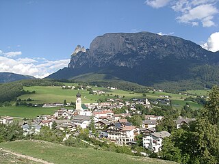
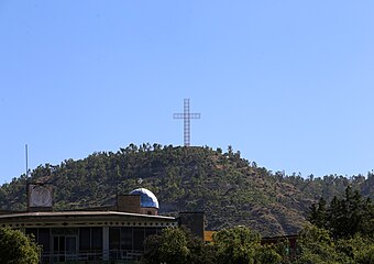
<span class="mw-page-title-main">Tre Cime di Lavaredo</span> Mountains in Italy

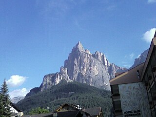
The Tre Cime di Lavaredo, also called the Drei Zinnen ; pronounced[ˌdʁaɪˈtsɪnən] ), are three distinctive battlement-like peaks, in the Sexten Dolomites of northeastern Italy. They are probably one of the best-known mountain groups in the Alps. The three peaks, from east to west, are:
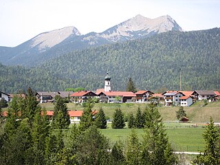
<span class="mw-page-title-main">Seis am Schlern</span>

Seis am Schlern is an Alpine village in South Tyrol, in the Trentino-Alto Adige/Südtirol region of northern Italy. It is a frazione of the comune of Kastelruth.
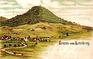
<span class="mw-page-title-main">Achen Lake</span> A lake in Tyrol, Austria

Lake Achen is a lake in Austria, north of Jenbach in Tyrol. Lake Achen is also called "Fjord of the Alps" and "Tyrolean Sea". The largest lake within the federal state, its maximum depth is 133 metres (436 ft). Together with the Achen Valley, it parts the Karwendel mountain range in the west from the Brandenberg Alps in the east.

<span class="mw-page-title-main">Wetterstein</span>

The Wetterstein mountains, colloquially called Wetterstein, is a mountain group in the Northern Limestone Alps within the Eastern Alps. It is a comparatively compact range located between Garmisch-Partenkirchen, Mittenwald, Seefeld in Tirol and Ehrwald along the border between Germany (Bavaria) and Austria (Tyrol). Zugspitze, the highest peak is at the same time the highest mountain in Germany.

<span class="mw-page-title-main">Heroes' Cross on Caraiman Peak</span>

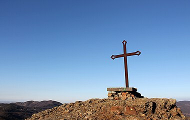
The Commemorative Cross to the Romanian Heroes of the First World War, also called the Heroes' Cross on Mount Cairaman is a monument built between 1926 and 1928 on Caraiman Peak at an altitude of 2,291 m located in Romania, in the Bucegi Mountains of the Southern Carpathians. It has a height of 39.3 metres (129 ft) and the nearest town is Buşteni. The name of the monument is "The Heroes' Cross", but it is popularly known as the "Cross on Caraiman".
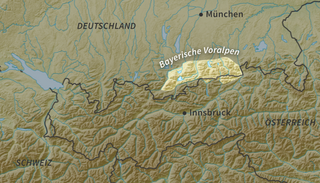
<span class="mw-page-title-main">Kleinglockner</span>

At the height of 3,770 metres (12,370 ft) the Kleinglockner is the third highest mountain summit in Austria. However, with a prominence of only 17 metres it is arguable whether it can be counted as an independent mountain, or just as a subpeak of the Großglockner. It lies in the Glockner Group of Austria's Central Alps, the middle section of the Hohe Tauern. Geographically and geologically speaking, it is viewed a secondary summit of the neighbouring Großglockner, but in the literature, in view of its importance to mountaineering, it is in some cases treated as separate. Its peak forms part of the Glockner crest or ridge (Glocknerkamm) and lies exactly on the border between the Austrian state of Carinthia and Lienz District in the East Tyrol. The Kleinglockner has the shape of a sharp edge, covered with the so-called Glockner Cornice (Glocknerwechte) and, depending on the conditions, can make the ascent of the mountain dangerous to almost impossible. The climbing history of the Kleinglockner is closely linked to that of the Großglockner, because the first climbers, coming from the south and east, had to cross it.

<span class="mw-page-title-main">Mittenwald Railway</span> Railway line

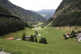
The Mittenwald Railway, popularly known as the Karwendelbahn, is a railway line in the Alps in Austria and Germany. It connects Innsbruck via Seefeld and Mittenwald to Garmisch-Partenkirchen.

<i>Standschützen</i>

The Standschützen were originally rifle guilds and rifle companies that had been formed in the 15th and 16th centuries, and were involved time and again in military operations within the borders of the Austrian County of Tyrol. A Standschütze was a member of a Schützenstand, into which he was enrolled, which automatically committed him to the voluntary, military protection of the state of Tyrol. In effect they were a type of Tyrolean local militia or home guard.

<span class="mw-page-title-main">Seefeld Plateau</span>

<span class="mw-page-title-main">Rietzer Grießkogel</span> Mountain in Tyrol, Austria

The Rietzer Grießkogel is a mountain, 2,884 m (AA), and the highest peak in the Northern Sellrain Mountains, part of the Stubai Alps in the Austrian state of Tyrol. The summit is easily climbed on path no. 153. The first documented ascent was undertaken in 1829 by Innsbruck botanist, Andrä Sauter, a brother of Anton Sauter. As a result of its easy accessibility on well marked paths from Telfs in the Inn Valley and from the Sellrain Valley, it is a popular destination. Its name is derived from the village of Rietz at its northern foot in the district of Imst in the upper Inn valley.
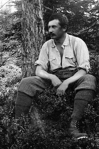
<span class="mw-page-title-main">Civic Archives in Bozen-Bolzano</span> Historic site in South Tyrol, Italy

The Civic Archives in Bozen-Bolzano are the municipal archive of the city of Bolzano in South Tyrol, Italy. They are located in the old town hall and store documents from over 700 years of civic and regional history.

References

  1. "Erstes gläsernes Gipfelkreuz der Welt". salzburg.orf. Retrieved 11 November 2010.
  2. 1 2 3 Wilhelm Eppacher (1957), Raimund Klebelsberg (ed.), "Berg- und Gipfelkreuze in Tirol", Schlern-Schriften (in German), Innsbruck: Universitätsverlag Wagner, vol. 178, pp. 5-9
  3. Reinhold Messner (1992), "Schöne neue Welt VERTIKAL", Bergsteiger (in German), vol. 6, pp. 71–73
  4. Friedrich's Morning Mist in the Mountains and his Cross in the Mountains (the Tetschen Altarpiece) are noted by Norbert Wolf, Caspar David Friedrich: 1774-1840 : the painter of stillness 2003:22f.
  5. Alpenvereinsmuseum, Phillipp Felsch, ed. (2007), Berge, eine unverständliche Leidenschaft (in German), Wien: Folio-Verlag, pp. 40, ISBN   978-3-85256-408-1
  6. Wilhelm Eppacher (1957), Raimund Klebelsberg (ed.), "Berg- und Gipfelkreuze in Tirol", Schlern-Schriften (in German), Innsbruck: Universitätsverlag Wagner, vol. 178, pp. 10
  7. Helen Fairbairn and Gareth McCormack, Lonely Planet Hiking in Ireland, 2010:110.
  8. Nicholas J. Saunder, "Crucifix, Calvary, and Cross: Materiality and Spirituality in Great War Landscapes", World Archaeology35.1, The Social Commemoration of Warfare (June, 2003:7-21), p. 12.
  9. "Crucea Caraiman, în Cartea Recordurilor: Este cea mai înaltă cruce din lume amplasată pe un vârf montan". Mediafax.ro (in Romanian). Retrieved 2021-03-22.
  10. "Gipfelkreuz Gipfelkreuz (Drama, Österreich 1948)". kino.de. Retrieved 11 November 2010.

Sources