Sumner, Oklahoma

Last updated

Sumner, Oklahoma
USA Oklahoma location map.svg
Red pog.svg
Sumner, Oklahoma
Location within the state of Oklahoma
Usa edcp location map.svg
Red pog.svg
Sumner, Oklahoma
Sumner, Oklahoma (the United States)
Coordinates: 36°19′8″N97°7′17″W / 36.31889°N 97.12139°W / 36.31889; -97.12139
Country United States
State Oklahoma
County Noble
Area
[1]
  Total0.15 sq mi (0.38 km2)
  Land0.15 sq mi (0.38 km2)
  Water0.00 sq mi (0.00 km2)
Elevation
[2]
938 ft (286 m)
Population
 (2020)
  Total35
  Density239.73/sq mi (92.87/km2)
Time zone UTC-6 (Central (CST))
  Summer (DST) UTC-5 (CDT)
FIPS code 40-71500
GNIS feature ID2812860 [2]

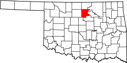
Sumner is a community and Census Designated Place [2] located in Noble County, Oklahoma, United States, ten miles east of Perry and two miles north of U.S. Route 64. Established prior to statehood along the St. Louis-San Francisco Railway, the post office opened on May 23, 1894. The town was named for Henry T. Sumner, a businessman from Perry. Per the 1905 Oklahoma Territorial Census, Sumner had sixty-four residents. The post office closed July 27, 1957.

The town currently has a population of approximately fifty. At its peak the town had a bank, post office, two churches, a school, a grain elevator, and a train stop. Currently, the only significant buildings still in use are the Baptist church, the Christian church and the school.

Demographics

Historical population
CensusPop.Note
2020 35
U.S. Decennial Census [3]

Related Research Articles

<span class="mw-page-title-main">Noble County, Oklahoma</span> County in Oklahoma, United States

Noble County is located in the north central part of Oklahoma. As of the 2020 census, the population was 10,924. Its county seat is Perry. It was part of the Cherokee Outlet in Indian Territory until Oklahoma Territory was created in 1890, and the present county land was designated as County P. After the U. S. government opened the area to non-Indian settlement in 1893, it was renamed Noble County for John Willock Noble, then the United States Secretary of the Interior.

<span class="mw-page-title-main">Grant County, Oklahoma</span> County in Oklahoma, United States

Grant County is a county located on the northern border of the U.S. state of Oklahoma. As of the 2020 census, the population was 4,169. Its county seat is Medford. Originally designated as part of the Cherokee Outlet, it was named County L in Oklahoma Territory at the time of its opening to non-Indian settlement. A county election renamed it for U.S. President Ulysses S. Grant.

<span class="mw-page-title-main">Tallahatchie County, Mississippi</span> County in Mississippi, United States

Tallahatchie County is a county in the U.S. state of Mississippi. At the 2020 census, the population was 12,715. Its county seats are Charleston and Sumner.

<span class="mw-page-title-main">Sumner County, Kansas</span> County in Kansas, United States

Sumner County is a county located in the U.S. state of Kansas. Its county seat is Wellington. As of the 2020 census, the population was 22,382. The county is named after Charles Sumner, a U.S. Senator from Massachusetts who was a leader of Reconstruction politics.

<span class="mw-page-title-main">Hunnewell, Kansas</span> City in Sumner County, Kansas

Hunnewell is a city in Sumner County, Kansas, United States. As of the 2020 census, the population of the city was 44.

<span class="mw-page-title-main">Park Hill, Oklahoma</span> Census-designated place in Oklahoma, United States

Park Hill is an unincorporated community and census-designated place (CDP) in southwestern Cherokee County, Oklahoma, United States. The population was 3,909 at the 2010 census. It lies near Tahlequah, east of the junction of U.S. Route 62 and State Highway 82.

<span class="mw-page-title-main">Stigler, Oklahoma</span> City in Oklahoma, United States

Stigler is a city in and county seat of Haskell County, Oklahoma. The population was 2,685 at the time of the 2010 census, down from 2,731 recorded in 2000.

<span class="mw-page-title-main">Cameron, Oklahoma</span> Town in Oklahoma, United States

Cameron is a town in Le Flore County, Oklahoma, United States. It is part of the Fort Smith, Arkansas-Oklahoma Metropolitan Statistical Area. The population was 302 at the 2010 census, a decline of 3.2 percent from the figure of 312 recorded in 2000.

<span class="mw-page-title-main">Agra, Oklahoma</span> Town in Oklahoma, United States

Agra is a town in northern Lincoln County, Oklahoma, United States. The population was 339 at the 2010 census. An early real estate developer coined the town's name from the word "agriculture".

<span class="mw-page-title-main">Sparks, Oklahoma</span> Town in Oklahoma, United States

Sparks is a town in Lincoln County, Oklahoma, United States. The population was 169 at the 2010 census, a 23.4 percent gain from the figure of 137 in 2000. The center of population of Oklahoma is located in Sparks.

<span class="mw-page-title-main">Dibble, Oklahoma</span> Town in Oklahoma, United States

Dibble is a town in McClain County, Oklahoma, United States. The population within city limits was 867 at the 2020 census, down from 878 at the 2010 census. The community has 8,868 residents in its 73031 zipcode, according to Sperling's Best Places. Dibble is in the outer suburban area west of Purcell and southwest of Norman, in the Oklahoma City Metropolitan Area, according to the U.S. Census.

<span class="mw-page-title-main">Goldsby, Oklahoma</span> Town in Oklahoma, United States

Goldsby is a town in McClain County, Oklahoma, United States. It lies within the Washington public school district and is home to the second largest casino in Oklahoma. As of the 2020 Census, the estimated population was 2,694, a 66 percent increase since 2010.

<span class="mw-page-title-main">Perry, Oklahoma</span> City in Oklahoma, United States

Perry is a city in, and county seat of, Noble County, Oklahoma, United States. As of the 2010 census, the city population was 5,126, a 2.0 percent decrease from the figure of 5,230 in 2000. The city is home of Ditch Witch construction equipment manufacture.

<span class="mw-page-title-main">Okemah, Oklahoma</span> City in Oklahoma, United States

Okemah is the largest city in and the county seat of Okfuskee County, Oklahoma, United States. It is the birthplace of folk music legend Woody Guthrie. Thlopthlocco Tribal Town, a federally recognized Muscogee Indian tribe, is headquartered in Okemah. The population was 3,078 at the 2020 census, a 6.1 percent decline from 3,223 at the 2010 census.

<span class="mw-page-title-main">Bethany, Oklahoma</span> City in Oklahoma, United States

Bethany is a city in Oklahoma County, Oklahoma, United States, and a part of the Oklahoma City metropolitan area. Bethany has a population of 20,831 at the 2020 census, a 9.3% increase from 2010. The community was founded in 1909 by followers of the Church of the Nazarene from Oklahoma City.

<span class="mw-page-title-main">Clayton, Oklahoma</span> Town in Oklahoma, United States

Clayton is a town in northern Pushmataha County, Oklahoma, United States. The population was 821 at the 2010 census.

<span class="mw-page-title-main">Hardesty, Oklahoma</span> Town in Oklahoma, United States

Hardesty is a town in Texas County, Oklahoma, United States. As of the 2020 census, the town’s population was 205.

<span class="mw-page-title-main">Okay, Oklahoma</span> Town in Oklahoma, United States

Okay is a town along the east bank of the Verdigris River in Wagoner County, Oklahoma, United States. The population was 620 at the 2010 census, a 3.9 percent increase over the figure of 597 recorded in 2000.

<span class="mw-page-title-main">Corn, Oklahoma</span> Town in Oklahoma, United States

Corn is a town in Washita County, Oklahoma, United States. The population was 503 at the 2010 census.

<span class="mw-page-title-main">Davis, Oklahoma</span> City in Oklahoma, United States

Davis is a city in Garvin and Murray counties in the U.S. state of Oklahoma. The population is 2,823 as of the 2020 census.

References

  1. "ArcGIS REST Services Directory". United States Census Bureau. Retrieved September 20, 2022.
  2. 1 2 3 U.S. Geological Survey Geographic Names Information System: Sumner, Oklahoma
  3. "Census of Population and Housing". Census.gov. Retrieved June 4, 2016.