Pitchcott is a village and civil parish in the Aylesbury Vale district of Buckinghamshire, England. It is about 3 miles (5 km) north-east of Waddesdon, slightly less than 4 miles (6.4 km) south of Winslow and slightly more than 4 miles north of Aylesbury. It is in the civil parish of Oving.

Upper Heyford is a village and civil parish about 6 miles (10 km) northwest of Bicester in Oxfordshire, England. The 2011 Census recorded the parish's population as 1,295.

Ambrosden is a village and civil parish in Cherwell, Oxfordshire, England, 3 miles (5 km) southwest of Bicester to which it is linked by the A41 road, and 13 miles (21 km) from Oxford. The 2011 Census recorded the parish's population as 2,248. The parish is bounded by the River Ray to the south, its tributary the River Bure to the west, the outskirts of Bicester to the north and field boundaries to the east.

Alvediston is a small village and civil parish in Wiltshire, England, about 7 miles (11 km) east of Shaftesbury and 11 miles (18 km) southwest of Salisbury. The area is the source of the River Ebble and is within the Cranborne Chase and West Wiltshire Downs Area of Outstanding Natural Beauty.

Barton Bendish is a civil parish and small ancient village in the English county of Norfolk located 10 miles (16 km) south of King's Lynn and 90 miles (140 km) North East of London. It has two medieval parish churches, and once had three. The parish includes the old hamlet of Eastmoor, and covers 3,936 acres (1,593 ha). The village has been settled since Neolithic times and was expanded during the Saxon period. Today the village has a population of 210 as recorded at the 2010 census and contains eight listed buildings, with the two medieval parishes churches being Grade I.
Cogges is an area beside the River Windrush in Witney, Oxfordshire, 0.5 miles (800 m) east of the town centre. It had been a separate village and until 1932 it was a separate civil parish.
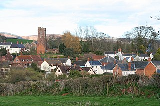
Stogumber is a village and civil parish in Somerset, England, on the eastern flank of the Brendon Hills. Besides Stogumber village itself, the parish includes the hamlets of Ashbeer, Capton, Escott, Higher Vexford, Kingswood, Lower Vellow, Lower Vexford, Preston, and Vellow. The village is on the route of the Samaritans Way South West.
Lower Sundon is a hamlet located in the Central Bedfordshire district of Bedfordshire, England.

Denchworth is a village and civil parish about 2.5 miles (4 km) north of Wantage. It was part of Berkshire until the 1974 boundary changes transferred the Vale of White Horse to Oxfordshire. The 2011 Census recorded the parish's population as 171. The parish is bounded by the Land Brook in the west and the Childrey Brook in the east. The Great Western Main Line between Reading and Swindon runs through the parish just south of the village, but there is no station.

Upper Sundon is a village located in the Central Bedfordshire district of Bedfordshire, England.

Tetsworth is a village and civil parish about 3 miles (5 km) south of Thame in Oxfordshire. Its Parish Council is made up of six elected Councillors. The estimated population in 2018 was 752 persons. According to the Council, business included the Zioxi educational furniture plant, the Swan antiques centre and some nearby equestrian and agricultural enterprises. The village no longer had a post office or many retail operations, but retained its "church, primary school, village hall, sports on the village green, and village pub and restaurant".

Oakhanger is a village in the East Hampshire district of Hampshire, England. Its nearest town is Bordon, which lies 1.7 miles (2.7 km) east, of the B3004 road. The village is part of the parish of Selborne, which covers an area of 7,915 acres (3,203 ha). The nearest railway station is Alton, which is 3.8 miles (6.1 km) northwest of the village, although Oakhanger formerly had its own military railway station, Oakhanger Halt railway station on the Longmoor Military Railway, until its closure.
Bossall is a hamlet in North Yorkshire, England with fewer than 100 residents.

Ettington is a village and civil parish about 5.5 miles (9 km) south-east of Stratford-upon-Avon in Warwickshire, England. The 2011 Census recorded the parish's population as 1,171. The present village is on the A422 main road linking Stratford and Banbury. The A429 main road linking Warwick and Cirencester used to run through the village, and now uses a bypass just west of it. The Fosse Way Roman road crosses the A422 0.6 miles (1 km) east of the village.

Lyford is a village and civil parish on the River Ock about 4 miles (6.4 km) north of Wantage. Historically it was part of the ecclesiastical parish of Hanney. Lyford was part of Berkshire until the 1974 boundary changes transferred the Vale of White Horse to Oxfordshire. The 2001 Census recorded the parish's population as 44. Lyford's toponym refers to a former ford the Ock, now replaced with a bridge on the road to Charney Bassett. "Ly" is derived from the Old English lin, meaning "flax". In 1034 it was recorded as Linford.

Pyrton is a small village and large civil parish in Oxfordshire about 1 mile (1.6 km) north of the small town of Watlington and 5 miles (8 km) south of Thame. The 2011 Census recorded the parish's population as 227. The toponym is from the Old English meaning "pear-tree farm".

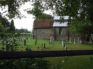
East Worldham is a village and former civil parish, now in the parish of Worldham, in the East Hampshire district of Hampshire, England. It is 1.9 miles (3.1 km) east of Alton; and 1.9 miles (3.1 km) south-west of Wyck. Hartley Mauditt and West Worldham are nearby, which, along with East Worldham, form the parish of Worldham. The village is just east of the A31 road and contains St Mary's Church and the Three Horse Shoes pub, amongst other buildings. Worldham Golf Course located just to west and Dean Farm Golf Course just to the east. For centuries the village and surrounding parish were owned by Winchester College. In 1931 the parish had a population of 208.

Chesterton is a village and civil parish on Gagle Brook, a tributary of the Langford Brook in north Oxfordshire. The village is about 1+1⁄2 miles (2.4 km) southwest of the market town of Bicester. The village has sometimes been called Great Chesterton to distinguish it from the hamlet of Little Chesterton, about 3⁄4 mile (1.2 km) to the south in the same parish. The 2011 Census recorded the parish population as 850.
Marston Meysey, pronounced and sometimes also spelt Marston Maisey, is a village and civil parish in Wiltshire, England, lying 3 miles (5 km) northeast of Cricklade on the county boundary with Gloucestershire. The parish includes the hamlet of Marston Hill. Marston Maisey is the spelling for the civil parish, but not for the village on Ordnance Survey maps.

Pillerton Hersey is a village and civil parish about 5.5 miles (9 km) north of Shipston-on-Stour in Warwickshire, England. The village is on a stream that flows northwest to join the River Dene. The 2011 Census recorded the parish's population as 170.
