Hudson's Hope is a district municipality in northeastern British Columbia, Canada, in the Peace River Regional District. Having been first settled along the Peace River in 1805, it is the third-oldest European-Canadian community in the province, although it was not incorporated until 1965. Most jobs in the economy are associated with the nearby W. A. C. Bennett Dam and Peace Canyon Dam, and timber logging.

Hope is a district municipality at the confluence of the Fraser and Coquihalla rivers in the province of British Columbia, Canada. Hope is at the eastern end of both the Fraser Valley and the Lower Mainland region, and is at the southern end of the Fraser Canyon. To the east, over the Cascade Mountains, is the Interior region, beginning with the Similkameen Country on the farther side of the Allison Pass in Manning Park. Located 154 kilometres (96 mi) east of Vancouver, Hope is at the southern terminus of the Coquihalla Highway and the western terminus of the Crowsnest Highway, locally known as the Hope-Princeton, where they merge with the Trans-Canada Highway. Hope is at the eastern terminus of Highway 7. As it lies at the eastern end of the Fraser Valley in the windward Cascade foothills, the town gets very high amounts of rain and cloud cover – particularly throughout the autumn and winter.

From 1942 to 1949, Canada forcibly relocated and incarcerated over 22,000 Japanese Canadians—comprising over 90% of the total Japanese Canadian population—from British Columbia in the name of "national security". The majority were Canadian citizens by birth and were targeted based on their ancestry. This decision followed the events of the Japanese Empire's war in the Pacific against the Western Allies, such as the invasion of Hong Kong, the attack on Pearl Harbor in Hawaii, and the Fall of Singapore which led to the Canadian declaration of war on Japan during World War II. Similar to the actions taken against Japanese Americans in neighbouring United States, this forced relocation subjected many Japanese Canadians to government-enforced curfews and interrogations, job and property losses, and forced repatriation to Japan.

The Fraser Valley Regional District (FVRD) is a regional district in British Columbia, Canada. Its headquarters are in the city of Chilliwack. The FVRD covers an area of 13,361.74 km² (5,159 sq mi). It was created in 1995 by an amalgamation of the Fraser-Cheam Regional District and Central Fraser Valley Regional District and the portion of the Dewdney-Alouette Regional District from and including the District of Mission eastwards.
Cassidy is an unincorporated community straddling Haslam Creek. near the east coast of southern Vancouver Island, British Columbia, Canada. The location on BC Highway 19 is about 98 kilometres (61 mi) by road north-west of Victoria, and 14 kilometres (9 mi) south of Nanaimo.

New Denver is a village in the Central Kootenay region of British Columbia, Canada at the mouth of Carpenter Creek, on the east shore of Slocan Lake, in the West Kootenay region of southeastern British Columbia. The village is 47 kilometres (29 mi) west of Kaslo on Highway 31A, and 47 kilometres (29 mi) southeast of Nakusp and 32 kilometres (20 mi) northeast of Slocan on Highway 6.
Cumberland is an incorporated village municipality east of Perseverance Creek, near the east coast of central Vancouver Island, British Columbia. The Comox Valley community is west of BC Highway 19 and is by road about 105 kilometres (65 mi) northwest of Nanaimo and 10 kilometres (6 mi) southwest of Courtenay.
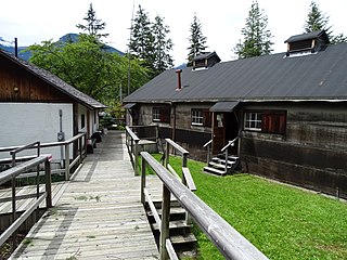
Nikkei Internment Memorial Centre is a museum that preserves and interprets one of ten Canadian concentration camps where more than 27,000 Japanese Canadians were incarcerated by the Canadian government during and after World War II. The centre was designated a National Historic Site of Canada in 2007.

E.C. Manning Provincial Park is a provincial park in British Columbia, Canada. It is usually referred to as Manning Park, although that nomenclature is also used to refer to the resort and ski area at the park's core. The park covers 83,671 hectares and was the second most visited provincial park in 2017-18 after Cypress Provincial Park. The park lies along British Columbia Highway 3, and occupies a large amount of land between Hope and Princeton along the Canada-United States border.

Hamber Provincial Park is a provincial park in British Columbia, Canada, located 130 kilometres (80.7 mi) north of Golden. Straddling the Great Divide on the provincial boundary with Alberta, the park is surrounded on three sides by Jasper National Park and protects the headwaters of the Wood River at Fortress Lake.

The Village of Slocan is in the West Kootenay region of southeastern British Columbia. The former steamboat landing and ferry terminal is at the mouth of Springer Creek, at the foot of Slocan Lake. The locality, on BC Highway 6 is about 69 kilometres (43 mi) by road north of Castlegar and 183 kilometres (114 mi) by road and ferry south of Revelstoke.
Minto City, often called just Minto, sometimes Minto Mines,Minto Mine, Skumakum, or "land of plenty", was a gold mining town in the Bridge River Valley of British Columbia from 1930 to 1936, located at the confluence of that river with Gun Creek, one of its larger tributaries. The mine prospect was never much successful although a model townsite was built by promoter "Big Bill" Davidson, who imported soil to build a specially-built rodeo ground and baseball diamond on the rocky site. The larger mine of Bralorne was nearby. The mine shut down in 1936 due to productivity issues, but restarted in 1940. The valley has since been significantly altered when most of the vestiges of the town were inundated by the waters of the Carpenter Lake reservoir following completion of the Bridge River Power Project. In 1941, around two dozens of Japanese Canadian families were relocated to Minto Mine, and ordered to live in the empty miners' houses due to the impacts of the war.
Japanese Canadians are Canadian citizens of Japanese ancestry. Japanese Canadians are mostly concentrated in Western Canada, especially in the province of British Columbia, which hosts the largest Japanese community in the country with the majority of them living in and around Vancouver. In 2016, there were 121,485 Japanese Canadians throughout Canada.

Shigetaka "Steve" Sasaki was a Japanese and Canadian judoka who founded the first judo club in Canada and is considered the 'Father of Canadian Judo'. After establishing the Tai Iku Dojo in Vancouver in 1924, Sasaki and his students opened several branch schools in British Columbia and also trained RCMP officers until 1942, when Japanese Canadians were expelled from the Pacific coast and either interned or forced to move elsewhere in Canada due to fears that they were a threat to the country after Japan entered the Second World War. When the war was over, the government required interned Japanese Canadians to either resettle in Canada outside of British Columbia's 'Japanese exclusion zone' or emigrate to Japan.
Jesse [Hideo] Nishihata (1929–2006), was a Canadian film director and producer. He worked on documentaries for the CBC, the NFB, and taught film and media studies at Ryerson University. During World War Two, he was interned at Tashme camp.
The Japanese martial art and combat sport judo has been practised in the Canadian province of British Columbia since the early 1900s, and it was the only place in the country where judo was practised prior to the Second World War. The first long-term judo dojo in Canada, Tai Iku Dojo, was established by a Japanese immigrant named Shigetaka "Steve" Sasaki in Vancouver in 1924. Sasaki and his students opened several branch schools in British Columbia and even trained RCMP officers until 1942, when Japanese Canadians were expelled from the Pacific coast and either interned or forced to move elsewhere in Canada due to fears that they were a threat to the country after Japan entered the Second World War. When the war was over, the government gave interned Japanese Canadians two options: resettle in Canada outside of British Columbia or emigrate to Japan. Some returned to the Pacific coast after 1949, but most found new homes in other provinces. Those that did return, many of whom were fishermen, worked hard to rebuild the community that they had lost, and today there are about 50 judo clubs throughout the province.
The Japanese martial art and combat sport judo has been practised in the Canadian province of Ontario since 1942.

The history of Japanese people in British Columbia began with the arrival of Manzo Nagano in New Westminster in 1877. Prior to 1942, British Columbia was home to 90% of all Japanese in Canada. In 2001, 44% of all Japanese Canadians lived in British Columbia, or about 1% of the province's total population.
The TashmeIncarceration Camp was a purpose-built incarceration camp constructed to forcibly detain people of Japanese ancestry living on the West Coast of Canada during World War II after the attack on Pearl Harbor. Located at the current unincorporated community of Sunshine Valley, east of Hope in British Columbia, Canada, Tashme was operational between 1942 and 1946 and had a peak population of 2,624 people to 2,636 people. Tashme was constructed on 600 acres of leased land for $500/year on the A.B. Trites Farm.
Grace Eiko Thomson is a Japanese-Canadian internment camp survivor. She is the founder of the Nikkei National Museum and Cultural Centre in British Columbia and a memoirist.
